Schölke
|
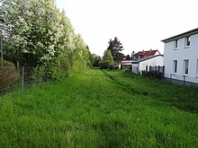
Schölke upper course: Jödebrunnengraben |
||
|
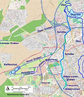
The Schölke and its tributaries in the western part of the city of Braunschweig |
||
| Data | ||
| Water code | DE : 482774 | |
| location | Lower Saxony , Germany | |
| River system | Weser | |
| Drain over | Oker → Aller → Weser → North Sea | |
| source |
Jödebrunnen 52 ° 15 ′ 9 ″ N , 10 ° 29 ′ 53 ″ E |
|
| Source height | 80 m | |
| muzzle |
Ölper coordinates: 52 ° 17 ′ 15 ″ N , 10 ° 30 ′ 2 ″ E 52 ° 17 ′ 15 ″ N , 10 ° 30 ′ 2 ″ E |
|
| Mouth height | 71 m | |
| Height difference | 9 m
|
|
| Catchment area | 4.64 km² | |
| Big cities | Braunschweig | |

The Schölke is a left tributary of the Oker in the western urban area of Braunschweig . Your source stream is the Jödebrunnengraben. It flows into the Oker in Ölper .
course
The Schölke rises as Jödebrunnengraben at the Jödebrunnen , but its name is only given in the official maps below the confluence of the Jödebrunnengraben and Kleiner Mittelriede at the Kälberwiese road (location 52 ° 17 ′ 15 ″ N , 10 ° 30 ′ 2 ″ E ).
The old town of Braunschweig was supplied with drinking water from the Jödebrunnen for over 500 years . The excess water flowed and continues to flow into the Jödebrunnengraben, which leads to the north. It is largely piped and leads through the flower pond . An openly designed section between Pippelweg and Kreuzstraße leads behind the property along Weinbergstraße and crosses Madamenweg at the former bunker. Another open section runs between Wiedenbeinstraße and Kälberwiese and is already referred to as Schölke on some maps. Until 2011 there was a connection to the Kleiner Mittelriede on Wiedenbeinstraße. A ditch from the area between Kälberwiese and Kreuzstrasse also flows there.
The tributary of the Kleine Mittelriede takes place at the level of the Oswald Berkhan School. There the Schölke tunnels under the Spatzenstieg and reaches the ring track , which accompanies it as a small river to the industrial site of the former MIAG . On the Triftweg, it is built over by a pumping station that relieves the stream during heavy rain events.
Before the Schölke disappears under the industrial site, it takes the Neue Graben coming from the Raffteich area to the left. After exiting the piping on Julius-Konegen-Straße, it runs continuously in a canalised manner and in the Sudetenstraße industrial area partially in a concrete base. In the Ölperaner area, the Ölper Graben, also coming from the left, joins the Otternweg. The Schölke flows parallel to the street Am Mühlengraben up to its confluence with the Oker.
meaning
The brook is classified as a 3rd order body of water, i.e. without any supra-regional significance. Its regional importance lies in the drainage of the entire area between the Chancellor's field in the north and Weststadt in the south.
Surname
The designation of the course of the river as "Schölke" already occurs in some maps for the Jödebrunnengraben from the height of the Wiedenbeinstraße. The name itself is first mentioned in writing in 1365 in connection with a manslaughter procedure as scoleken , the root of which goes back to the Low German term for "flush, flow, make waves". In the surroundings of Braunschweig there are other rivers with this name, such as two tributaries of the Fuhse in Salzgitter . In Braunschweig, Schölkestrasse bears her name, but the Neue Graben actually runs next to it.
Tributaries
Small middle peace
In contrast to the Mittelriede , the creek, known as the Kleine Mittelriede, has its origin in the Westpark . It flows as a ditch south of Lehndorf to the east and crosses under the A391 at the Kälberwiese. The Kleine Mittelriede crosses the Feldstrasse and limits the settlement area of the Kälberwiese to the south. To the west and east of Feldstrasse, a flood area was created in 2011 for flood protection and a previously existing southern connection to the Schölke was interrupted. The brook meets the Schölke at the Oswald Berkhan School.
In some historical maps the ditch called Mittelriede is shown in addition to the Neuer Graben as an outflow from the middle Raffteich, while in the more recent city maps the flow directions of various streams and drainages point to an origin in the area of the allotment garden association Kröppelberg south of the Madamenweg. There is a small spring pond there and the terrain slopes slightly to the northwest. To the north of Madamenweg, a meadow ditch branches off in the direction of the Raffeiche to the Neuer Graben and is sometimes referred to as Wilder Boden Graben in the official map of Lower Saxony . The branch north of the Madamenweg that drains to the east is named Schölkebach on the same map , while the city drainage system of Braunschweig calls it Weststadtgraben . At Strombeckstrasse it flows into the stream, which from there is called the Mittelriede . This is also the namesake for an allotment garden. A brook flows through this, which takes up several trenches from the western part of the city to the south on Madamenweg, including the IGS trench that begins at Erftsraße .
In the map of the area around Braunschweig from 1755 the Kleine Mittelriede near Lehndorf bears the name Die Raffteichs Riede and meets the Schölke at the level of the Feldstrasse, i.e. in the area of today's flood retention basin. In 1915 the city maps show various branches of the Kleiner Mittelriede that meet the Schölke, the southernmost one being in the area of Weinbergstraße. A stream from the Feldmark still flows there today.
- Surname
As with her namesake Mittelriede , the name can be traced back to the compound word -riede for "stream, small body of water".
New ditch
The Neue Graben begins at the dam of the lower Raffteich. There is an outlet structure for both adjacent fish ponds, where the Wilde Boden Graben also ends. The difference in level between the pond area and the ditch is around four meters. The Neue Graben is already marked on the maps of the Prussian land survey and runs in a straight line on the southern edge of the old core of Lehndorf towards Schölke, which it reaches in front of the site of the former MIAG near the Lehndorfer mill. It is largely piped and spanked. In contrast to the Kleiner Mittelriede, it hardly takes any further drainage from the field marrow.
- designation
The name Neuer Graben appears on the official maps . The city drainage of Braunschweig lists him in the investigation of water quality commissioned by them under the name Neuer Graben Lehndorf .
Ölper ditch
The Ölper Graben runs between Ölper Holz and the center of Ölper on the line of the old Braunschweiger Landwehr and reaches Ölper at the Alte Landwehr road. In the settlement area of Lehndorf, its open course begins in a concrete floor at the street Breite Riede , which could be a reference to its earlier name. Before that it flows hidden from the Lammer Holz under the sports area and south of the street Am Horstbleek. In the upper reaches it is connected to the Lammer Graben , which is fed from several sources south of the Chancellor's field in the depression near Lamme. There is still an old waterworks there, the status of a water protection area was revoked by the city of Braunschweig from 2012. The direction of flow of the Lammer Trench is towards the west, i.e. towards the floodplain , so it does not belong to the catchment area of the Oker.
Flood protection
Triftweg pumping station
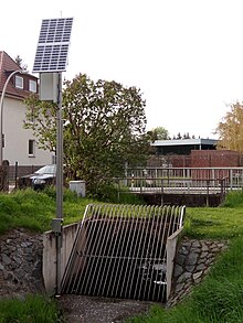
During floods in 2002 it came in the catchment area of Schölke to severe flooding and damage to private property. In order to prevent such damage in the future, the Triftweg pumping station has been upgraded to drain the rainwater directly into the rainwater sewer system and thus to the Oker, thereby relieving the lower course of the Schölke. To protect the pumps, an eye-catching, wide-meshed stainless steel grille is installed in front of the Triftweg road bridge with an overflow warning. There is a bypass with an emergency opening at the pumping station.
Expansion of the Kleine Mittelriede
In 2011, extensive redesigns were implemented in the Feldstrasse area. In front of the Feldstrasse, the brook below the allotment garden area "Im Altfeld" has been widened to around 10 meters and is flooded when the water is high. About 100 meters further down the stream, a tree-lined green area was partially dredged and transformed into a pond landscape with islands while maintaining the old tree population. An overflow threshold with variably deployable dam beams allows the water that is backed up during heavy rain events to overflow into the relief area. An outlet flap returns the trapped water to the stream when the water level drops. A compensation volume of 6,550 m³ is available.
Water quality
Stadtentwässerung Braunschweig published a water quality report for 2011. There, the extremely poor structural quality of the waters in the western urban area is pointed out, which is also documented in color on a structural quality map. The waters listed here have the worst rating, namely class VII "alien" or "excessively damaged". Only in the area of the Westpark are better ratings because of the partially natural banks of the meadow ditches. The biological quality of the urban waters is rated with quality class II-III, which means "critically polluted". These examinations are repeated cyclically.
Web links
Individual evidence
- ↑ a b Land surveying Lower Saxony: Topographic map 1: 50,000 , status 2002
- ↑ NLWKN : Area directory for the Lower Saxony hydrographic map , status 2010, retrieved from Umwelt.niedersachsen.de on August 19, 2013
- ↑ Environmental Atlas of the City of Braunschweig, Fließgewässer, Braunschweig 2007
- ↑ a b Herbert Blume : Oker, Schunter, Wabe. In: Braunschweigisches Jahrbuch für Landesgeschichte. Vol. 86, Braunschweig 2005, p. 22 ff.
- ^ City of Braunschweig: City map 1: 20000 , Braunschweig 1980.
- ↑ LGN : Official Topographical Map 1.5000 , status May 2013, retrieved from navigator.geolife.de
- ↑ a b c Institute for Geoecology at the TU Braunschweig: Water structure and water quality investigations in flowing waters of the city of Braunschweig, annual report 2011 , Braunschweig, website of the city of Braunschweig in May 2013.
- ^ City of Braunschweig: Official Gazette for the City of Braunschweig , December 29, 2011
- ↑ Braunschweiger Zeitung of July 21, 2004: Flood hot spots in sight .
- ↑ Stadtentwässerung Braunschweig / Ingenieurbüro Pabsch & Partner: Planning permission 2682-08-HRB Kleine Mittelriede, additions to the explanatory report of November 12, 2010 , Hildesheim 2010.
- ^ Stadtentwässerung Braunschweig: SE | BS: Quality and structure of Braunschweig rivers pleasing , Braunschweig July 26, 2012, accessed on May 8, 2013


