Rokytne Raion (Rivne)
| Rokytne district | |
| (Рокитнівський район / Rokytniwskyj rajon) | |

|

|
| Basic data | |
|---|---|
| Oblast : | Rivne Oblast |
| Administrative headquarters : | Rokytne |
| Area : | 2,350 km² |
| Residents : | 51,926 (2001) |
| Population density : | 22.1 inhabitants per km² |
| KOATUU : | 5625000000 |
| Municipalities : | 12 + 2 |
| District administration | |
| Address : | вул. Незалежності 13 34200 смт. Рокитне |
| Rajonsvorleiter: | Mykola Hrushchak |
| Website : | http://www.rv.gov.ua/sitenew/rokytnivsk |
| Overview map | |

|
|
| Statistical information | |
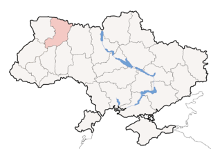
The Rokytne Raion (Ukrainian Рокитнівський район / Rokytniwskyj rajon ; Russian Рокитновский район / Rokitnowski rajon ) is a Rajon in the Rivne Oblast in western Ukraine . The center of the district is the urban-type settlement of Rokytne .
geography
The Raion is located in the northeast of the Oblast and borders in the north on Belarus ( Woblasz Brest , Rajon Stolin and Woblasz Homel , Rajon Leltschyzy ), in the east on Olevsk Raion (in Zhytomyr Oblast ), in the southeast on Novohrad-Volynskyi Raion (Oblast Zhytomyr), in the southwest to the Beresne district , in the west to the Sarny district and in the northwest to the Dubrowyzja district . The Rajon lies in the area of the Pripyat Marshes and is therefore heavily forested and very swampy. Due to these characteristics, it is only sparsely populated.
history
The Rajon was created on January 17, 1940 after the occupation of Eastern Poland by the Soviet Union , then came after the beginning of the German-Soviet War in June 1941 to the Reichskommissariat Ukraine in the general district of Brest-Litovsk / Volhynia-Podolia , district of Sarny and after the reconquest in 1944 back to the Soviet Union in the Ukrainian SSR . It then existed in a smaller form until January 21, 1959, when it was enlarged by parts of the dissolved Klessiw Rajon (the Rajon capital was Klessiw ). On December 30, 1962, the Rajon was then united with other Rajons with the Sarny Rajon , but this merger was reversed on January 4, 1965. Since 1991 it has been part of what is now Ukraine.
Administrative structure
At the municipal level, the Rajon is divided into 2 settlement councils, 12 district councils and 1 rural municipality, each of which is subordinate to individual localities.
The administrative area includes:
- 2 urban-type settlements
- 37 villages
Urban-type settlement
| Urban-type settlements | |||
|---|---|---|---|
| Surname | |||
| transcribed in ukrainian | Ukrainian | Russian | Polish |
| Rokytne | Рокитне | Рокитное (Rokitnoye) | Rokitno |
| Tomashhorod | Томашгород | Томашгород (Tomashgorod) | Tomaszgród |
Villages
| Villages | ||||
|---|---|---|---|---|
| Surname | Parish assignment | |||
| transcribed in ukrainian | Ukrainian | Russian | Polish | |
| Beresowe | Березове | Берёзовое (Berjosowoje) | Berezów | Beresowe |
| Bilovish | Біловіж | Беловеж (Belowesch) | Białowiż | Bilovish |
| Bilsk | Більськ | Бельск (Belsk) | Bielsk | Blaschowe |
| Blaschowe | Блажове | Блажово (Blaschowo) | Bleżowo | Blaschowe |
| Borowe | Борове | Боровое (Borowoje) | Borowe | Borowe |
| Buda | Буда | Буда | Buda | Massevychi |
| Budky-Kamjanski | Будки-Кам'янські | Будки-Каменские (Budki-Kamenskije) | Budki Wojtkiewickie | Kamjane |
| Budky-Snowydowyzki | Будки-Сновидовицькі | Будки-Сновидовичские (Budki-Snowidowitschskije) | Budki Snowidowickie | Snowydowytschi |
| Chmil | Хміль | Хмель (Chmel) | Chmiel | Hlynne |
| Dert | Дерть | Дерть | The C | Kyssorychi |
| Drosdyn | Дроздинь | Дроздынь | Drozdyń | Starlings Selo |
| Dubno | Дубно | Дубно | Dubno | Hlynne |
| Hlynne | Глинне | Глинное (Glinnoje) | Glinno | Hlynne |
| Hrabun | Грабунь | Грабунь (Grabun) | Grabuń | Beresowe |
| Jelne | Єльне | Ельное (Jelnoje) | Jelno | Tomashhorod |
| Kamjane | Кам'яне | Каменное (Kamennoje) | Kamień | Kamjane |
| Karpylivka | Карпилівка | Карпиловка (Karpilovka) | Karpiłówka | Karpylivka |
| Kupel | Купель | Купель | Kupiel | Bilovish |
| Kyssorychi | Кисоричі | Кисоричи (Kissoritschi) | Kisorycze | Kyssorychi |
| Lissowe | Лісове | Лесовое (Lessowoje) | Świniki, Świnnyki | Rokytne |
| Massevychi | Масевичі | Масевичи (Massevichi) | Masiewicze | Massevychi |
| Pussy | Мушні | Мушни | Muszno | Bilovish |
| Netreba | Нетреба | Нетреба | Netreba | Borowe |
| Obsessive | Обсіч | Обсич | Opsycz | Kamjane |
| Oleksandrivka | Олександрівка | Александровка (Alexandrowka) | Aleksandrówka | Kyssorychi |
| Osnyzk | Осницьк | Осницк (Osnitsk) | Ośnick | Rokytne |
| Ostky | Остки | Остки (Ostki) | Ostki | Snowydowytschi |
| Perechodychi | Переходичі | Переходичи (Perechoditschi) | Perechodzicze | Starlings Selo |
| Posnan | Познань | Познань | Poznań | Hlynne |
| Rokytne | Рокитне | Рокитное (Rokitnoye) | Rokitno | Rokytne |
| Sabolottja | Заболоття | Заболотье (Sabolotje) | Podmościszcze | Beresowe |
| Salavja | Залав'я | Залавье (Salavye) | Załawie | Blaschowe |
| Snowydowytschi | Сновидовичі | Сновидовичи (Snowidowitschi) | Snowidowicze | Snowydowytschi |
| Starlings Selo | Старе Село | Старое Село (Stare Selo) | Starlings Sioło | Starlings Selo |
| Staryky | Старики | Старики (Stariki) | Rudnia-Staryki | Rokytne |
| Tomashhorod | Томашгород | Томашгород (Tomashgorod) | Tomaszgród | Tomashhorod |
| Veschytsia | Вежиця | Вежица (Weschitsa) | Wieżyce | Starlings Selo |
See also
Web links
swell
- ↑ ukase of the Presidium of the Supreme Soviet of the USSR of 17 January 1940 "Про утворення районів в складі Волинської, Дрогобичської, Львівської, Ровненської, Станіславської і Тарнопольської областей УРСР"
- ↑ Президія Верховної Ради УРСР; Указ від 01/04/1965 № 2н-06 Про внесення змін в адміністративне районування Української РСР
- ↑ http://oblrada.rv.ua/mistseve_samovryaduvannya/admin_ustrij.php?SECTION_ID=93&ELEMENT_ID=4695

