Rapho Township
| Rapho Township | |
|---|---|
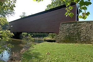
 Schenck's Mill Covered Bridge in Rapho Township |
|
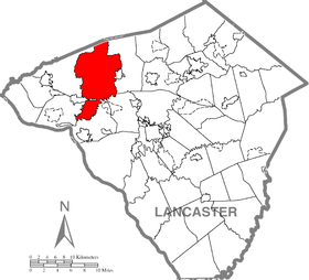
| Location of the township in the county. Location of the county in Pennsylvania |
|
| Basic data | |
| Foundation : | 1721 (settled) 1741 (incorporated) |
| State : | United States |
| State : | Pennsylvania |
| County : | Lancaster County |
| Coordinates : | 40 ° 12 ′ N , 76 ° 30 ′ W |
| Time zone : | Eastern ( UTC − 5 / −4 ) |
| Residents : | 10,442 (as of 2010) |
| Population density : | 84.8 inhabitants per km 2 |
| Area : | 123.1 km 2 (approx. 48 mi 2 ) of which 123.1 km 2 (approx. 48 mi 2 ) is land |
| Height : | 170 m |
| Area code : | +1 717 |
| FIPS : | 42-63440 |
| GNIS ID : | 1216642 |
The Rapho Township is a township in northwest Lancaster County in Pennsylvania , United States . In 2010 the township had 10,442 inhabitants.
geography
According to the United States Census Bureau , the township has a total area of 123.1 km 2 , all land. The township is named after Raphoe in County Donegal in Ireland .
history
Kauffman's Distillery Covered Bridge , Mount Hope Estate , Forry's Mill Covered Bridge, and Siegrist's Mill Covered Bridge are on the National Register of Historic Places .
Demographics
At the time of the United States Census 2000, Rapho Township had 8,578 people. The population density was 69.7 people per km 2 . There were 3,185 housing units, an average of 25.9 per km 2 . The population in Rapho Township was 97.72% White , 0.29% Black or African American , 0.08% Native American , 0.80% Asian , 0% Pacific Islander , 0.51% said other races belong to and 0.59% named two or more races. 0.80% of the population declared to be Hispanic or Latinos of any race.
The residents of Rapho Townships were distributed among 3,075 households out of which 35.0% were living in children under 18 years of age. 70.5% of households were married, 4.7% had a female head of household without a husband, and 22.0% were not families. 18.6% of households were made up of individuals and someone lived in 7.0% of all households aged 65 years or older. The average household size was 2.76 and the average family size was 3.17.
The population was divided into 27.1% minors, 7.5% 18–24 year olds, 28.1% 25–44 year olds, 25.6% 45–64 year olds and 11.7% aged 65 and over or more. The median age was 38 years. For every 100 women there were 103.0 men. For every 100 women over 18, there were 98.4 men.
The median household income in Rapho Township was 50,063 US dollars and the median family income reached the amount of 55,625 US dollars. The median income for men was $ 36,935 compared with $ 25,402 for women. The per capita income was $ 20,412. 4.1% of the population and 3.0% of families had an income below the poverty line , including 2.9% of minors and 6.4% of those aged 65 and over.
supporting documents
- ^ National Register Information System . In: National Register of Historic Places . National Park Service . Retrieved July 9, 2010.

