Ratanwadi
| Ratanwadi रतनवाडी |
||
|---|---|---|
|
|
||
| State : |
|
|
| State : | Maharashtra | |
| District : | Ahmednagar | |
| Location : | 19 ° 31 ' N , 73 ° 43' E | |
| Height : | 750 m | |
| Area : | 17.76 km² | |
| Residents : | 1,118 (2011) | |
| Population density : | 63 people / km² | |
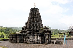
| Ratanwadi - Amruteswara Temple | ||
Ratanwadi ( Marathi : रतनवाडी ) is a village with about 1150 inhabitants in the Ahmadnagar district in the Indian state of Maharashtra .
location
Ratanwadi lies in the Western Ghats at an altitude of approx. 750 m above sea level. d. M. on the small river Pravara , a tributary of the Godavari ; of Lake Arthur Reservoir is only about 2 km away. The district capital Ahmednagar is about 160 km (driving distance) to the southeast, but the metropolis of Nashik is only 85 km to the north. Because of the altitude, the climate is moderate; Rain falls mainly in the summer monsoon season .
population
The population consists almost exclusively of Hindus . The male population is around 5% higher than the female.
economy
Agriculture has been the basis of (survival) life in the rain-rich mountain region for centuries. In the last decades of the 20th century, inner-Indian tourism was added as a source of income.
history
The place was largely outside the territorial and political interests of the regional and supra-regional powers. The nearby Ratangad Fort was conquered by the marath leader Shivaji in the late 17th century .
Attractions
- The most important sight is the Amruteshwara temple from the late 9th century, about 150 m north of the village; it was built by King Jhanj as one of 12 Shiva temples in the region. It consists of three components - a vestibule ( mandapa ) supported by figuratively and ornamentally carved pillars , an anteroom ( antarala ) and the cella ( garbhagriha ) elevated by a conical tower ( shikhara ). What is unusual is the fact that there is also an entrance at the back of the temple, so that the cella can also be entered directly from the outside by the Brahmin priests . In front of the rear entrance portico there are two reclining Nandi statues.
- Surroundings
- The mountainous and wooded area is ideal for hiking. The Ratangad Fort, located approx. 5 km to the south-west and only accessible on foot, encloses an approx. 1200 m high hilltop in the Kalsubai Harichandragad Wildlife Sanctuary . The fort has several gates and wells.
- The highest mountain in Maharashtra, the approximately 1646 m high Kalsubai , is about 20 km (as the crow flies) north.


