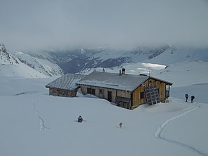
Refuge du Mont Thabor
| Refuge du Mont Thabor CAF hut |
||
|---|---|---|
| Mountain range | Cottian Alps , Cerces massif | |
| Geographical location: | 45 ° 7 '24.3 " N , 6 ° 35' 59.3" E | |
| Altitude | 2502 m | |
|
|
||
| builder | Club Alpin Français Maurienne section | |
| owner | Club Alpin Français Maurienne section | |
| Built | 1979/80 renovated in 2007/08 |
|
| Construction type | hut | |
| Usual opening times | Mid-February to late April, mid-June to mid-September |
|
| accommodation | 48 beds, 0 camps | |
| Winter room | 30 bearings | |
| Hut directory | DAV | |
The Refuge du Mont Thabor is a refuge of the Maurienne section of the Club Alpin Français (CAF) in the Cerces massif , at an altitude of 2502 m in the Auvergne-Rhône-Alpes region.
history
On the Grande Traversée des Alpes ( German big crossing of the Alps ) and on the long-distance hiking trail GR 5 , the stage between Modane and the Vallée Etroite ( German narrow valley ) was very long, so it was necessary to build a refuge in this stage. The approval of the French army was required for the construction, so that construction was only possible in 1979.
The ideal place for the hut would have been at the Col de la Vallée Étroite , directly on the hiking trails. However, in order to receive subsidies, it was necessary to build the hut higher than 2,500 m. It therefore takes 15 minutes from the hiking trails to the hut.
The hut was inaugurated on June 22, 1980.
Space available
During the working time, the hut offers space for 48 hikers, accommodated in dormitories between 7 and 13 beds. Otherwise 30 people will find accommodation.
In summer water from the mountains is collected at the hut, while in winter and spring it either has to be transported up from the valley or ice has to be fetched from the lake 5 minutes away and melted.
Access
- Drive from Modane to Valfréjus and from there follow the GR 5 long-distance hiking trail (600 m altitude difference, 2 hours)
- from the parking Granges through the Vallée Etroite the Col de la Vallée Etroite over (m Altitude 700, h 3)
hikes
In addition to the GTA and GR 5 , the GR 57 (circular route around Mont Thabor , 85 km in length) can also be reached from the hut .
You can also reach from the hut:
- Col de la Roue ( 2541 m )
- Ridge between Col des Bataillères ( 2804 m ) and Col des Roches ( 2836 m )
- Lac Rond and Lac Long (two lakes, 2510 m )
- Pointe des Sarrasins ( 2963 m )
Ski touring
- Mont Thabor ( 3178 m ), various routes
- Grand Argentier ( 3046 m )
- Pointe des Sarrasins ( 2963 m )
- Cheval Blanc ( 3020 m )
- Gran Bagna ( 3080 m ), various routes
- Mounioz ( 2745 m )
- Pointe Balthazar ( 3153 m ), various routes
- Pointe de Terre Rouge ( 3080 m )
- Pointe des Roches ( 3014 m )
- Roche Bernaude ( 3222 m )
Promotion opportunities
- Mont Thabor ( 3178 m ), two different routes on the north flank
- Pic du Thabor ( 3207 m ) over the west or south flank
- Grand Séru ( 2888 m )
Climbing opportunities
- Cheval Blanc ( 3020 m ), various routes
- Rocher de Pra Dieu ( 2390 m ), various routes
Web links
- Hut website. (French).
- Refuge du Mont Thabor. German Alpine Club
- Refuge du Mont Thabor. Club Alpin Française(French).
- Refuge du Mont Thabor. In: camptocamp.org. (French).
- Refuge du Mont Thabor. In: skitour.fr. (French).
- Refuge du Mont Thabor. In: refuges.info. (French).
Individual evidence
- ↑ La construction du refuge. Refuge du Thabor, accessed on May 25, 2020 (French).
- ↑ GR 57 Tour of Mount Thabor. In: gr-infos.com. Retrieved May 25, 2020 (English).

