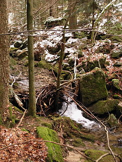
Rettenbacher Mühlbach
|
Rettenbacher Mühlbach Loderbach |
||
| Data | ||
| Water code | DE : 158814 | |
| location | Bavaria | |
| River system | Danube | |
| Drain over | Rettenbacher Mühlbach → Bogenbach → Danube → Black Sea | |
| source | in the Schwarzacher Hochwald east of the Schopf 48 ° 57 '22 " N , 12 ° 51' 39" E |
|
| Source height | about 870 m above sea level NN | |
| muzzle | 900 m west of Rettenbach Coordinates: 48 ° 58 ′ 31 ″ N , 12 ° 50 ′ 17 ″ E 48 ° 58 ′ 31 ″ N , 12 ° 50 ′ 17 ″ E |
|
| Mouth height | about 591 m above sea level NN | |
| Height difference | about 279 m | |
| Bottom slope | about 86 ‰ | |
| length | 3.3 km | |
| Catchment area | 6.93 km² | |
The Rettenbacher Mühlbach , also called Loderbach, is a three-kilometer long stream in the Straubing-Bogen district in Lower Bavaria . Together with the Englmarbach it is a source brook of the Bogenbach .
course
From the headwaters east of the summit of the Schopf in the Schwarzacher Hochwald, it flows north in the direction of Rettenbach to the Rettenbacher Mühle . Then west down into the valley of the Bogenbach.
environment
Parts of the stream are designated as a biotope. Brown trout are found in the water . Black storks find food by the stream .
Use of hydropower
Today hydropower plants generate electricity with pressure lines. There used to be the "Rettenbacher Mühle" and the "Feldmer Säge".
Web links
Commons : Rettenbacher Mühlbach - Collection of images, videos and audio files
Individual evidence
- ↑ a b BayernAtlas of the Bavarian State Government ( notes )
- ↑ a b Directory of the brook and river areas in Bavaria - Naab to Isar river area, page 111 of the Bavarian State Office for the Environment, as of 2016 (PDF; 2.8 MB)
- ↑ Reduction of the landscape protection area in the area of the municipality of St. Englmar . Statement of the Federal Nature Conservation in Bavaria eV (BN). 2005, p. 3 ( online [PDF]).


