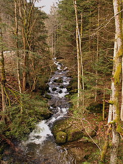
Englmarbach
|
Englmarbach old name: Engelmarbach |
||
|
immediately before the confluence with the Rettenbacher Mühlbach |
||
| Data | ||
| Water code | EN : 1588 | |
| location | Bavaria | |
| River system | Danube | |
| Drain over | Englmarbach → Bogenbach → Danube → Black Sea | |
| source | 500 meters southeast of the Pröller summit 49 ° 1 ′ 4 ″ N , 12 ° 49 ′ 29 ″ E |
|
| Source height | about 1007 m above sea level NN | |
| muzzle | 900 m west of Rettenbach Coordinates: 48 ° 58 ′ 31 ″ N , 12 ° 50 ′ 17 ″ E 48 ° 58 ′ 31 ″ N , 12 ° 50 ′ 17 ″ E |
|
| Mouth height | about 591 m above sea level NN | |
| Height difference | about 416 m | |
| Bottom slope | about 70 ‰ | |
| length | 6 km | |
| Catchment area | 10.11 km² | |
The Englmarbach (formerly Engelmarbach) is a six kilometer long stream in the Straubing-Bogen district in Lower Bavaria . It flows with the Rettenbacher Mühlbach, which comes from the left and is both shorter and deeper in the basin, to the Bogenbach .
course
The brook flows through the wooded headwaters southeast of the summit of the Pröller in a slightly easterly curve until it reaches the village of Sankt Englmar near Hügelhof . Now the village is crossed, partly piped, in order to serve as an attraction in the spa park over a length of about 500 meters. A new branching of the water was created at a small pond. The western branch largely corresponds to the historical course through the old mill . The newly created eastern branch feeds further ponds and takes up the other branch in one of them. Now it's two kilometers in the Kerbtal almost in a straight line south-southeast along the Hilmer Leite on the right . After an S-bend, the last section follows, now to the south, along the Rettenbacher Leiten on the left to the confluence with the Rettenbacher Mühlbach. The Englmarbach never leaves the municipality of Sankt Englmar. In the last section it is the border water to the municipality of Perasdorf for 200 meters .
history
In the repertory for the atlas sheet Mitterfels, three mills on Engelmar-Bächel are mentioned around 1820 : in Englmar ( ⊙ ), in Staudenau and the sawmill. ( ⊙ )
Individual evidence
- ↑ a b BayernAtlas of the Bavarian State Government ( notes )
- ↑ a b Directory of the brook and river areas in Bavaria - Naab to Isar river area, page 111 of the Bavarian State Office for the Environment, as of 2016 (PDF; 2.8 MB)
- ↑ Engelmarer Mühle on BayernAtlas
- ↑ Sawmill on Bavaria Atlas
- ^ Repertory of the topographical atlas sheet .... [49], Mitterfels . Munich 1829, p. 83 , urn : nbn: de: bvb: 12-bsb10944957-0 ( digital copy ).
