
Rheinhafen Krefeld
| Rheinhafen Krefeld | |||
|---|---|---|---|
| Data | |||
| UN / LOCODE | DE KRE and DE KDU | ||
| owner | City of Krefeld and Neuss-Düsseldorfer Häfen GmbH & Co. KG | ||
| operator | Hafen Krefeld GmbH & Co. KG | ||
| start of building | May 10, 1903 | ||
| opening | July 6, 1906 | ||
| Port type | Inland port | ||
| Total area of the port | 500ha | ||
| Piers / quays | 11.4 km | ||
| Goods handled | Steel, grain, stones, building materials, fuels | ||
| Throughput | 3.22 million tons (2010) | ||
| website | www.rheinhafen-krefeld.de | ||
| Geographic information | |||
| place | Krefeld | ||
| country | North Rhine-Westphalia | ||
| Country | Germany | ||
 |
|||
| Coordinates | 51 ° 20 '43 " N , 6 ° 39' 40" E | ||
|
|||

The Rheinhafen Krefeld is an inland port on the left bank of the Lower Rhine (km 762.1 to km 766.3). It was inaugurated on July 6, 1906 and is operated by Hafen Krefeld GmbH & Co. KG. The entrance to the harbor basin is exactly under the Krefeld-Uerdinger bridge . More than 5.5 million tons were handled in 2019. This makes it the fourth largest public inland port in North Rhine-Westphalia (see list ).
history

During archaeological excavations a 180 meter long quay wall was found that belonged to the Roman fort Gelduba . The port was also used after Roman times. But it shifted further north due to the shifting of the river bed. In the Middle Ages it was a transshipment point for the area around the Electorate of Cologne and Crefeld. The Uerdinger Rheinwerft has been part of the (initially Krefeld-Uerdinger, later Krefeld) port since 1929.
In 1901, the Krefeld city council decided to build a port in the recently incorporated town of Linn . For this purpose, the Rhine island in front of the site was filled with over three million cubic meters of earth and connected to the mainland at its upstream end. A swing bridge leads across the resulting harbor basin . There is a quay wall around 400 m long on the banks of the Rhine .
During the Second World War , more than 70% of the facilities were destroyed in a total of 150 bombing raids, especially the industrial plants there.
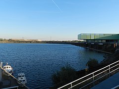
By 1960, other companies settled in the port area and an expansion of the port became necessary. For the recreational boating has its own marina at Rhine kilometer 759.8 on the left. There are suitable jetties for small vehicles and their own supply and disposal facilities. For this purpose, the quarry pond at the end of the harbor basin, which was accessible via a canal, was used from 1970. The harbor basin is around 3.5 km long and has a large turning basin. In 1988 a container terminal was built at the head of the harbor . The Port of Krefeld has been cooperating with the Neuss-Düsseldorf ports since 2008 .
Infrastructure
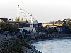
The port area covers around 500 hectares and the total bank length is 11.4 km. In 2010, a total of 3.22 million tonnes (rail and ship traffic) were handled. This makes Krefeld the fourth largest port in North Rhine-Westphalia . Four in-house crane systems are available for loading. Other loading facilities for petroleum products, grain and bulk goods are maintained by the companies based in the port themselves. A 200-ton heavy lift crane from Klösters is located at the turning basin. The container terminal has two container loading bridges with a load capacity of up to 40 tons, two reach stackers , connections for 16 refrigerated containers and 32,500 m² of storage space, 500 m² of which is covered. In addition, a separate extinguishing water collection basin has been set up for hazardous goods containers.
traffic
The port company operates its own railway company (EVU) with a route length of 50 km and four locomotives. There are direct connections to the rail network of Deutsche Bahn AG.
Local roads and the federal highway 288 open up the port area to the two kilometers to the west running federal highway 57 .

Harbor master's office
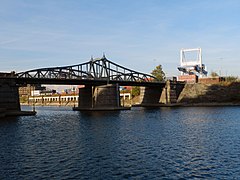
Swing bridge in the harbor basin
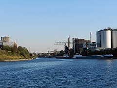
Loading points on the west bank
Reversible basin and steel loading point

Heavy lift crane at the turning basin


The Rheinwerft Uerdingen
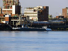
Uerdingen has a 3.7 km long Rhine front and is located at Rhine km 765. The Uerdinger Rheinwerft, which has been used as a loading point and transshipment point for more than 700 years, joins the Krefeld port entrance. 1306-1307 there was a customs list with about 20 Uerdinger ships. The city of Uerdingen was next to Rheinberg for many decades the most northerly electoral Cologne city on the Rhine and therefore extremely important in terms of customs policy, so that it was fortified with a city wall in the 14th century (first mentioned in 1333). The Rhine side was secured with an imposing castle. The first permanent embankment walls were built on the Rhine around 1854. In 1887 and 1888 the Uerdingen shipyard was redesigned to meet the requirements of the new era. It was essentially given its present form.
The passenger shipping today uses a private pier with floating pontoon , the Uerdinger Steiger, at the Causeway, take place as landing in an area where no cover today more. Day trips and multi-day trips are carried out regularly by the Eureka shipping company and the white fleet Mülheim.
The piers of CHEMPARK Krefeld-Uerdingen are from river kilometers 765.4 and 766.3.
Old crane on the Uerdinger Ufer

Crane system at the CHEMPARK
Tanker loading point

View of the loading points at CHEMPARK Uerdingen


Web links
- Official website of the port of Krefeld
- Official website Krefelder Container Terminal
- CHEMPARK Krefeld-Uerdingen website
Individual evidence
- ↑ rheinhafen-krefeld.de: 51% belong to the city of Krefeld, 49% to Neuss-Düsseldorfer Häfen GmbH & Co. KG
- ↑ rheinhafen-krefeld.de
- ^ History of Uerdinger Hafen
- ↑ History of Krefeld ( Memento of the original from May 3, 2016 in the Internet Archive ) Info: The archive link was automatically inserted and not yet checked. Please check the original and archive link according to the instructions and then remove this notice.
- ↑ Krefeld sports boat harbor