
Gelduba
| Gelduba | |
|---|---|
| Alternative name | Fort Krefeld-Gellep, Fort Gellep |
| limes | Lower Germanic Limes |
| Dating (occupancy) | Aa − c) 69/70 B) 70/71 to 80/85 C.a) 80/85 to the middle of the 2nd century. Cb) the middle to the end of the 2nd century. Cc) the end of the 2nd century to around 260 D) 261 / 262 to 275/276 E.a) 275/276 to 287/288 (?) Eb) 287/288 (?) To 294/295 E.c) 294/295 to after 320 E.d) after 320 to around 341 Ee) around 341 to 353 / 355 F) 353/355 to 369 G.a) 369 to 387/388 (?) Gb) 387/388 (?) Before 400 H) before 400 to 5th century |
| Type | Aa-c) marching camp B) cohort or Alenkastell C.a-b) cohort fort D) Alenkastell F) vacant |
| unit | Aa − c) unknown Vexillationes B) unknown cohort or Ala C.ac) Cohors II Varcianorum equitata (?) D) unknown Ala Ea − b) unknown federates Ec) unknown troop Ed − e) unknown British troop F) no occupancy |
| size | B) around 140 × 170 m |
| Construction | Aa − c) Wood-earth camp B) Wood fort C.a) Wood fort C.b) Mud brick construction C.c) Stone fort |
| State of preservation | ground monument not visible above ground |
| place | Krefeld - Gellep |
| Geographical location | 51 ° 19 '59.5 " N , 6 ° 40' 57" E |
| Previous |
Asciburgium (north) Small fort Werthausen (north) |
| Subsequently | Novaesium (south) |
Gelduba was a Roman garrison site on the Lower Germanic Limes . The fort was built near an ubic oppidum of the same name . Today's ground monument is located in the Gellep-Stratum district of Krefeld on the Lower Rhine . The settlement area became particularly famous for its necropolis , of which over 6000 graves have been archaeologically examined. The holding time of the burial sites ranging from the first to the eighth century, and thus has a rare settlement continuities from the Roman to the Merovingian time.
location


The area in which Gelduba would later be built has been a preferred settlement site since the Neolithic , the continuity of which is evidenced by the finds of stone tools and ceramic shards as well as Bronze and Iron Age graves, of which a total of over 50 were found. Due to its close proximity to the river, the site was conveniently located on a flood-free knoll of the lower terrace of the Rhine, about ten meters above its height. In addition, the place was favored by a stream flowing into the Rhine there and by the hinterland ideally suited for arable farming.
Ancient sources
In the ancient sources Gelduba is mentioned in the Naturalis historia of Pliny and repeatedly in the Historiae des Tacitus , in the latter case in particular in connection with the events of the Four Emperor's Year and the Batavian Revolt in 69/70. In the Antonini Itinerarium , Gelduba can be found between Novaesium ( Neuss ) and Calo , nine leagues away from these places.
Research history
Knowledge of Gelduba and his identity with Gellep never seems to have been entirely lost over the centuries. Already in the five-volume travel guide “Rhenus”, published in 1571, the clergyman Bernardus Mollerus made this equation and in the middle of the 17th century it was familiar to the Cologne historiographer Aegidius Gelenius . When at the beginning of the 18th century some historians believed, due to the similarity of names, that the fort was located in the city of Geldern , the historian Werner Teschenmacher rejected this view and correctly identified the village of Gellep as the missing Gelduba . In 1810, the Uerdingen merchant Heinrich Wilhelm Herbertz reported on the first robbery excavations , and interested buyers of the artifacts were the soldiers of the Napoleonic occupation army.
The first scientific writings on the Gelduba fort were written by Anton Rein, rector of the Krefeld secondary school in 1851 and 1857, and by the Uerdingen teacher Franz Stollwerck in 1877. Up to this point, however, there was no question of scientific archeology in Krefeld. Excavations were determined by the attractiveness and / or the usability of the finds, contexts of the finds were largely ignored. Extensive private collections with finds from Gelduba were thus created in the course of the 19th century, almost all of which, however, fell victim to the two world wars.
In 1896 the Krefeld high school professor August Oxé was the first to carry out smaller archaeological excavations with a scientific claim, where he came across some graves and walls of the auxiliary fort. In 1914 and 1930, south and south-east of Gellep, further, not particularly extensive investigations by the Rheinisches Landesmuseum Bonn (most recently under the direction of Kurt Bittel ) were carried out without any significant results.
The start of systematic large-scale excavations in Gellep is closely linked to the name of Albert Steeger , who had been a geologist and rector of a middle school until then. In 1934 he began scheduled excavations in the Gelleper grave field. In the following two years he uncovered Franconian burials from the 6th and 7th centuries, as well as late Roman and early Franconian graves from the time of transition from antiquity to the Middle Ages, especially from the 5th century. In 1936 he left the school service and devoted himself exclusively to his excavations and the construction of a local museum. By his death in 1958 he had unearthed 1,198 burials. Renate Pirling , director of the Burg Linn Museum Center , continued his work in the Roman-Franconian grave field from 1959 to 1994, where well over 6,000 graves have now been recovered. While Albert Steeger devoted himself to the burial ground in the 1950s, Wilhelm Piepers (1954 and 1955) and Gustav Müller (1958) from the Rheinisches Landesmuseum Bonn dug in the area of the vicus. The fort area was examined in the 1960s by Christoph B. Rüger and Ilse Paar . Christoph Reichmann (director of the Burg Linn Museum Center since 1996) has been the excavation manager for investigations in the fort and vicus area since the early 1980s .
Gelduba up to the time of the Batavian revolt
The name of the later Roman garrison Gelduba was a settlement of local people, from which a village of the Ubier emerged at the beginning of the 1st century. The village was located immediately north of today's Gellep in the curve of the Mühlenbach tributary into the Rhine. This brook (formerly called Gelfbach) marked the border between the Germanic Cugernians who settled in the north and the Ubiians who lived in the south . Since the founding of the colony under Trajan and Claudius , the northern area belonged to the administrative district of the Colonia Ulpia Traiana (Xanten) and the southern area including Gelduba to the Colonia Claudia Ara Agrippinensium (Cologne).
Germanic settlement
The area of the Germanic settlement had already been archaeologically examined between 1969 and 1977. Traces of settlement in the form of post holes , foundation trenches, waste pits and well shafts were uncovered over a large area . According to the finds, the village was founded in the last quarter of the first century BC and existed until the end of the sixties of the first century AD. The series of coins closes with a minting of the year 68, and the recovered pottery does not provide any indication of a longer period of settlement. Pronounced traces of fire showed that the settlement must have come to a violent end. At this point the archaeological evidence coincides with the written source of Tacitus, who reports in his histories of heavy fighting between Roman troops and Batavian rebels near Gelduba . At the time of the outbreak of the Batavian uprisings, a Roman intervention force was in the civilian village of the Ubier; as a defensive measure against the attacks of the insurgents, pitfalls and trenches had been dug.
Roman "mass grave"
The opponents met on the site on the banks of the Rhine at what would later be the Gelduba fort.
The unusual finding of a burial of around forty human and as many horse skeletons also points to these armed conflicts. They were all sunk into the ground at only a shallow depth (0.7 m to 1.0 m below the current site surface). The orientation of the individual graves was inconsistent, as was the position of the skeletons. Some lay on their side, some in the embryo position with their knees drawn up. Two or three individuals were repeatedly found lying on top of one another in a common burial place. In addition to individual horse graves in between, there were also pits in which humans and horses were buried together. The entire group of graves gave the impression that the burials had been carried out in a hurry. No traces of any coffins were discovered, grave goods were almost completely missing. However, the discovery of a single fibula , a bronze bridle and other harness parts , all of which were dated to the second half of the first century, made a chronological assignment possible.
Marching camp of the vocula
The Upper Germanic governor Hordeonius Flaccus and the commander of the IV. Legion, Gaius Dillius Vocula , had gathered departments of the Mainz, Bonn and Neuss legions and auxiliary troops on the Lower Rhine. The purpose of the operation was to relieve the Vetera / Birten legionary camp, which was besieged by Iulius Civilis and his Batavern. Archaeologist Christoph Reichmann discovered possible traces of the marching camp of Gaius Dillius Vocula, mentioned in connection with the Batavian uprising near Tacitus and located north of Novaesium , outside the area of the later auxiliary fort and not far from the Ubian settlement. The findings consisted of several pointed trenches about three meters wide and two meters deep, traces of gates and wooden towers, as well as a crescent-shaped defensive trench that extended to the site of the later fort. According to the fact that they were backfilled, the trenches could only have been open for a relatively short time. The overall sparse find material allowed a dating to the second half of the first century. Due to the reconstructable overall size of the camp, it can be seen as a marching camp serving 8,000 to 12,000 legionnaires and is therefore definitely considered the marching camp of Vocula.


After the Batavian Uprising - the history of the castles
Gelduba was the location of partially mounted auxiliary troops and, during the Batavian uprising, it was also the temporary garrison site of a larger group of troops. The military camp, which was first erected in the civil place Gelduba in 69 AD - secured by digging trenches - was in distress during the Batavian uprising and the place was destroyed. The actual fort with the camp suburb (vicus) and port facility was built south of the village.
In the 3rd and 4th centuries the fort was destroyed several times. In the 5th century the fort was reinforced again by an outer wall, around 420 it appears to have been temporarily manned with Burgundians in Roman services, according to the finds . People were buried in the associated cemetery in the 6th century.
Overview
The fort phase of Gellep / Gelduba begins in 71 AD after the Batavar attack on the previous military camp near the civil place (locus) Gelduba and ends with the capture of the Lower Rhine by the Franks in the middle of the 5th century.
The fort area is still today on the top of a flat sand dune, which in Roman times was up to 9 m above the bed of the Rhine. The created wells therefore had a depth of up to 11 meters. Not far from the hill, a little north of the former civilian locus Gelduba, the Gelfbach (today's Mühlenbach) flowed into the Rhine. After Tacitus Gelduba was the northernmost place in the field of civitas Ubiorum, so the country's settled there Ubii . This Gelfbach formed the borderline to the north living Cugernians , from whose pronunciation the historical name Gelduba and today's place name Gellep derive from Gellef to Geldeb.
Archeology has identified a total of nine fort phases, beginning with period I at the former locus Gelduba in the Batavian rebellion. Periods II to V concern the first actual fort (with smaller additions and improvements to the fort structure and the fortifications from phase to phase). Period VI to IX concern the castles of the late Roman period.
The first fort was initially built as an auxiliary troop camp, surrounded by trenches and earth walls, which was redesigned and expanded over the years. In the years around 200 AD it experienced its greatest expansion (approx. 150 × 190 meters), including a camp suburb (vicus), surrounded by cult sites, pastures, parade grounds, watchtowers and fields.
After the Franconian raids in 275/276 with extensive destruction of the old fort, there was initially a transition period without regular occupation, but local auxiliary troops were hired as militiamen who settled with their families on the fort grounds. Around this time, many camp village residents left the vicus and settled elsewhere, possibly on an offshore Rhine island. Remnants of this island settlement as well as the harbor, which was still in use for a long time, existed until the Middle Ages (which finds, including a sunken Rhine barge from the Carolingian era, prove).
From around 285/290 under Emperor Diocletian the construction of a new fort began (the first fort from the late Roman period). It was expanded and expanded several times and existed until the year 352. This fort was also burned down in the middle of the 4th century and the last, the youngest, was built on its rubble: a smaller, but better fortified and thick-walled complex, most recently with one polygonal castle wall surrounded.
After 420 AD this fort was also given up; its ruins lasted until the 13th century. After the fall of Cologne in 459, the Franks also took control of the former Gelduba, and their archaeological traces can be traced back to the 8th century.
Gelduba garrison (the first fort from 71 to 275 AD)
The first fort, which was built around 71 AD after the Batavian raids, was about 200 m long × 165 m wide in the second century, facing the bank of a side arm of the Rhine - separated from the main stream by islands. The development from a wood and earth fort to a stone fort as well as local shifts and enlargements could be demonstrated. The oldest and probably smallest fort consisted of a wall made of wood and earth, which was protected by two approx.5.50 m wide pointed trenches (built 71 AD to approx. 100 AD). The second period is another pointed trench, which originally had a row of palisades in a sack-like depression that ran parallel to the top of the trench as an additional obstacle to the approach. In the second century the complex was surrounded by a real wall, with gates and towers.
In the older Roman times it functioned as a camp for auxiliary troop units (auxilia), which differed from the legions by their inferior legal status. The soldiers were usually provincial residents (peregrinae) without Roman citizenship. In a Roman road map, the "Itinerarium Antonini", Gelduba is mentioned in the early 3rd century as the location of an Ala (cavalry unit of 500 men).
Fort and infrastructure around 200 AD
- The Troop :
- There are brick stamps from the early bathing building built after 72, u. a. with A SULP CR ; the Ala Sulpicia had been set up in southern Spain. The CR in the stamp means civicum Romanorum and indicates cumulative civil rights. There is a tombstone from the end of the 1st century that indicates the Cohors II Varcianorum cR equitata , a unit that possibly replaced the Ala Sulpicia. Another, partially mounted (equitata) Varcian cohort came from Pannonia (today's Hungary).
- The first fort had reached its greatest extent around 200 AD, surrounded by the camp village, pastures and fields, parade grounds, watchtowers and other useful infrastructure. The crew consisted of the cohors secunda Varcianorum equitata civium Romanorum, a partially mounted auxiliary unit of around 500 men. A prefect was in command of the troops.
- A consecration stone from the second century to the matrons indicates that the matrons were recruited from the Balkans. The cohort of a cohort from the province of Dacia (today's Romania) was identified as the founder. A troop composed of Celtic Varcians in the province of Pannonia (today's Hungary) had probably been in Gelduba since the 1980s, reinforced by local recruits up to the year 200. The soldiers of this unit had Roman citizenship. Their commander was Tiberius Claudius Proculus Cornelianus. Another unit is known from brick stamps from the early third century, a smaller reconnaissance troop called the Numerus Ursariensium - it is believed that this troop was set up in Lower Germany.
- The fortification (structures) :
- In the first years of its existence, the fort still largely resembled a field camp, but surrounded by trenches and protected by a surrounding outer wall, which was supplemented with watchtowers and gates over time. Everything was geared towards a force that was quickly ready to move out and come into contact with the enemy in an emergency. The barracks were timber frame buildings, some buildings had been converted into workshops. Only the staff building (principia) in the center of the fort and the storage facility on the Rhine side were made of masonry. The rest of the buildings, such as the commandant's house (praetorium), were made from a combination of stones, mud bricks and wood.
- Camp suburb (the vicus) :
- Each fort included an unpaved suburb with shops, workshops, restaurants and entertainment venues. The families or relatives of the soldiers also lived there; the initial marriage ban for active soldiers was relaxed around AD 200 and completely lifted by Emperor Severus. The main vicus of Gelduba was immediately south of the fort. This was where the family accommodations, craft workshops, the bathhouse, as well as the houses of long-distance traders and the hostel for business travelers were located. There was a small market square with adjoining shops (tabernae), which after 230 (the time of the Franconian invasions) was equipped with a slightly larger area for regular weekly markets. The construction of the market stalls in separate rows (rows of stalls) is typical for port cities of the time and suggests ship merchants and other seasonal traders.
-
- Fort bath (thermal baths) :
- The cavalry unit (ala Sulpicia) set up in Spain had already built a smaller bathhouse, which, however, burned out in the mid-1980s. The second bathhouse, located in the vicus, was larger and more comfortable, with an inner columned hall, which was reinforced by 230 with walls between the columns, making it more defensive. Apartments and shops were also set up or added to. Between 259 and 268 the bathhouse was destroyed in raids, it was rebuilt in the meantime, but in 274/75 it was probably finally destroyed by raids from the Franks. Instead, a new, smaller bath was built within the fort walls.

-
- Merchant houses:
- The main camp village, the southern vicus, extended from the fort along the Rhine with its own port access. There were blocks surrounded by streets for houses, accommodations, street stalls, pubs, and other buildings, including the large bathhouse. In a building block reserved for merchants, there were five more than 40 m long, partly two-story buildings, with the main front facing west. The integrated living rooms were partially equipped with underfloor heating. The long-distance trade merchants had their ships anchored in the harbor and were probably involved in the lucrative trade in products from Hellweg. Finds of inscriptions in Aramaic indicate, among other things, long-distance traders from the area of today's Syria.
-
- Accommodation for military business travelers (mansio):
- The location of the mansio is not clearly archaeologically proven in Gelduba. It is assumed that the remains of a larger stone-built building complex found by Albert Steeger in the 1950s in the southern vicus belong to these mansio. In addition to the actual apartments for the travelers, the mansio also contained stables and parking spaces for touring carriages.
-
- Market and North Vicus:
- Right in front of the northern exit gate of the fort there was a small market area with clay banquets and wooden stalls, which were supplemented by a wooden hall around 200. From there a winding path led to the relatively small northern vicus opposite the main camp village in the south of the fort. Later this nödlirche market lost some of its importance compared to the weekly markets in the south of Vicus.
- Grave fields:
- The Gellep-Stratum site is particularly well-known for its extensive and extensively investigated burial fields, which were by no means the greatest extent around AD 200. These grave fields have extended along the access roads since the first fort was built around AD 70, because the Romans did not separate their dead from the living; Via the memorial stones and monuments erected, the dead should remain in the memory of passers-by. There were also burial sites along the large Limesstrasse (Römerstrasse, today Düsseldorfer Strasse in the Stratum district). Only the area immediately next to the fort was kept free. The Franks who pushed in from the 5th century onwards adopted this custom in Gelduba and expanded the old Roman burial grounds to the south.
- Port, river Rhine and Rhine islands:
- The Rhine was not an original border river between the Germans and the Celts - both ethnic groups settled on both sides of the banks of the Rhine - it was only Caesar who determined the Rhine to be the "border of the empire". Augustus temporarily moved this border to the Elbe until, under Tiberius around 16 AD, the border to the Rhine was withdrawn again, until the end of Roman times. The Rhine then ran a little more west than it does today, with some Rhine islands dividing the river and the narrower arm flowing past Gelduba. Not far from the fort, at the former “locus Gelduba” (the pre-fort period Ubier settlement), the Gelfbach (Mühlenbach) flowed into the Rhine (it marked the borderline between the area of the Cugernians settling in the north and that of the Ubier settling in the south ). The port canal of the Krefeld Rhine port now largely flows in the bed of this old arm of the Rhine and ends south of the fort vicus in the turning basin. In Roman times there was a long wooden quay wall that was secured with basalt fillings and allowed access from both the fort and the camp village. The remnants of the former Roman port were completely removed during the pebbles for the turning basin. The port must have been usable until the Carolingian period (around 800), because a sunken ship from this period was lifted during the excavations.
- Long-distance trade and highways:
- In the cattle and game enclosures in the vicinity of the fort, animals were kept and bred (e.g. aurochs and deer), which were brought from the country between the Elbe and the Rhine via the old Hellweg to Gelduba. There were many salt springs along the Hellweg and the salt that was extracted also reached Gelduba and from there - as well as furs, live animals, vegetable and animal products - via long-distance trade routes or by ship to other areas of the empire.
- The historian Pliny the Elder, who was killed in the eruption of Vesuvius in 70, discovered a special herb exported from Gelduba to the empire called Siser. Ae. handed down in his writings (although it is not known which spice it actually was). Finds indicate the presence of bear trappers (to supply the arenas of Cologne and Xanten). a. a bear tooth originally set in a bronze case.
- One of the roads that served not only troop movements but also long-distance trade was the large Limesstrasse that accompanied the Rhine (today known as Römerstrasse in large parts of the Lower Rhine, and Düsseldorfer Strasse in Gellep-Stratum). This Limes road was in the area of the Lower Rhine as early as 19 BC. BC under the governor Agrippa. It was up to 20 feet (6 m) wide - as proven by excavations in Asberg / Asciburgium - and paved with gravel substrates. In Gellep, too, today's route and other overland routes still follow the old Roman roads, including the road connections from Gelduba via Traiectum / Maastricht to Aduatuca / Tongeren, which ran to the southwest and were built in the early Flavian era.
- Mithraeum and cult shafts:
- On the road leading out of the fort to the west, there were private cult sites at a crossroads - in the area of the horse pastures, one of which was dedicated to the ancient Egyptian Isis. The largest cult site was on the edge of the north-western burial ground. In 1981 the floor plan of this wooden building was uncovered, which turned out to be the site of the Mithras cult in Asia Minor. The basic dimensions are 12.50 by 6.00 m; There were two podiums in the building and a central aisle with a cult image, probably Mithras as a bull-killer. Evidence of a fireplace and the remains of cult vessels were found, probably for collecting blood from the sacrificed bull.
- The area around the fort:
- Only a few archaeological traces point to the buildings and infrastructure in the vicinity of the fort.
-
- Parade ground:
- It is known that every cavalry unit had its own place, which had to be near the actual fort and was also used for parades and competitions.
-
- Country estates (villae rusticae):
- Only a few remains of the estates in the hinterland of Gelduba have so far been found, including those near a brickworks, from which apparently not only clay bricks but also stone building material, including tuff from the Eifel, were processed and delivered.
-
- Fields and Gardens:
- The Roman fields at Gellep, which were always at right angles, were probably located along the streets leading to the southwest, as one can assume from the Prussian original cadastre from 1830. Botanical examinations by Dr. Karl Heinz Knörzer resulted in an area in the vicinity of the fort that was largely converted into cultivated land, including orchards and timber plantations.
-
- Brickyard:
- In the vicinity of today's Ölvebach (tributary of the Mühlenbach) several residential buildings were cut; roof tiles, floor slabs and vaulted tiles were found that indicate a Roman brick factory. The oldest bricks are stamped from the end of the 1st century and can be found throughout the 2nd century. Deliveries from Gelduba can be proven as far as Nijmegen.
-
- Watchtowers and beneficiary station:
- Of the watchtowers typically found in the vicinity of forts, none have been archaeologically proven in Gellep. As an indication of a beneficiary station (police station, manned by deserving former officers) there are remains of a consecration stone that a beneficarius consularis placed around 206.
-
- Germanic settlements:
- In addition to Roman or Roman-Gallic models, there were also farms in the local style. Traditional Germanic farming methods and livestock farming were also retained there. From the 3rd century farmhouses in Germanic construction have been found in the vicinity of the fort, in wooden scaffolding and clay construction, with a deepened stable area, the roof was covered with thatch. On the other side of the Rhine across from Gelduba there were Germanic settlements. An associated burial ground was discovered in Ehingen (today part of Duisburg). The settlements consisted of small groups of courtyards with stables, outbuildings (weaving huts) and storage buildings on stilts
The end of the old fort
In the years 274 and 275 the Franks broke through the border fortifications of the Lower Rhine on a broad front and also devastated the "old" Gelduba fort. At this point in time, the camp village (the vicus) was largely abandoned by its population (who may have settled on a Rhine island), as research by Albert Steeger and W. Piepers at the beginning of the 1950s showed. Extensive incendiary layers dating back to 274 were discovered. The island settlement existed until the Middle Ages, there are traces that point to a bridge connection between the fort bank and the Rhine island.
Transitional period / the auxiliary troop fort (around 274 AD)
After the momentous attack by the Franks in 274/275, the fort was initially only temporarily repaired. The storehouses in particular were rebuilt as emergency supplies were needed for the remaining population and for the troops operating in the hinterland. Gelduba now had the status of a "security fort" (which, however, was still largely in ruins); the crew no longer consisted of regular troops who were tied up elsewhere in the turmoil of the empire. In order to protect the Roman properties, including the harbor, which was still in favorable conditions as a supply base, Germanic farmers and their families were allowed to settle on the surrounding area and in the area of the dilapidated fort; these "militaries" apparently took over tasks as local auxiliary contingent to guard the still existing Roman facilities. Remains of post houses were found, the models of which can be found in the Meuse region (Noord-Brabant, Gelderland and Limburg).
When General Constantius Chlorus, who was born in Britain, was raised to Caesar in 293 , he began with the "reconquest" in the Rhineland and the reconstruction of important bases, including in Gellep-Gelduba. Administratively, the province of Germania inferior was transformed into Germania secunda . This was the end of the auxiliary fort in Gellep-Gelduba and a new beginning for the town and garrison.
First late Roman fortress (294/95 to 369)
With the new beginning begun under Diocletian , a glamorous era began again for Gellep-Gelduba from around 294/295. Even if old moats and a large part of the still standing wall remnants were included in the new building, it was still a completely different fort, which from the beginning looked more like a medieval castle.
- The building and outdoor facilities were built, partly asymmetrically, purely from a defense-technical point of view; First, a second fort wall and thus a strong core fortification was raised in the interior of the old fort on a reduced floor plan. There was only one large gate on the landside, which initially only allowed access into the inner wall, like a kind of outer bailey. Intruders would also have had to overcome a second wall. Archaeological findings indicate that the builders of the complex came from the east of the Roman Empire.
- Although Gelduba has now been given an impressive fortress with a corresponding crew, the name “Gelduba” no longer appears in documents from that time. Instead, there is a reference to a place Trepitia in an itinerary by the so-called geographer of Ravenna (around 700) . A spelling Tracia (reinterpreted in Tertia) Trepitia sive Gildoba - Trepitia formerly Gelduba - is mentioned from a list of saints from the 7th century. Possibly - but unproven - the reference to a (temporary) name change after an occupation of the "third legion", similar to what happened in Xanten from Colonia Ulpia Traiana in Tricensimae . A Roman settlement near Drüpt was also identified with Trepitia .
- Whether Gelduba or Trepitia - the new late Roman fortress was constantly expanded and enlarged from the original building in 294 in several phases up to the year 320 and finally brought to the size of the original "old" fort.
- At the time of Emperor Constantine the Great (306–337) there was relative calm on the Lower Rhine and in Gellep, luxurious buildings were built again in the area of the old camp village - and, judging by the grave finds, the place had its highest population. However, shortly after Constantine's death, the incursions of the Franks increased again, and Gelduba must also have been affected around 341, which is indicated by exposed moat walls from this time.
- At the time of Emperor Diocletian (284–305) and in the early years of Constantine (306–337) two different units were stationed in Gellep; western horsemen (from the Batavian area) and eastern foot troops, probably from Egypt. Members of the Sarmatian equestrian people also seem to have served in Gellep (which is indicated by a typical "Sarmatian mirror" found, which was ritually broken when its owner died). Brooches and ceramics are also known from graves from this period, whose origins point to Westphalia and the Elbe-Weser triangle, which suggests recruits (from Suebi or Burgundy ) from these areas.
- Probably in the year 353 AD the (presumed) Gelduba "Trepitia" perished completely - traces of the undermining of a castle wing which had collapsed testify to the event. A little later Cologne fell (initially temporarily) into the hands of the Franks.
The last fort (370 until the end of Roman times)
After the fall of the fort, there were initially some “fallow phases” such as soil samples from debris deposits. Under Emperor Valentinian I , the construction of a new - the last - fortress began around 370, which over the decades was provided with extensions and additions until the end of the Roman presence on the Lower Rhine - and as a ruin until the 13th century. Century.
- A semicircular bastion and a rectangular gate tower served to secure the fort, which had a single land-side entrance. In terms of its basic dimensions, it was smaller than its predecessor (around 90 × 120 meters in the walled area) and built into the old fort grounds at a slight angle. The old moat and wall fortifications were still used, as were the intact streets of the previous forts.
- Initially, it was a simple rectangular structure with 2.20 m thick walls into which the military accommodation (barracks) were integrated on the inside. The building was three-story, the ground floor was already 4.40 m (16 steps) high, above it the upper floor with 2.20 m (eight steps) and above it the defense platform, all covered by a roof. Around 388 the building was expanded to include semicircular shell towers and the last major building measure was the construction of a polygonal front wall at the beginning of the 5th century.
- After armed conflicts in the years 390 to 420 (coins found in this way), trenches were dug in the forecourt to ward off the enemy and barricades and road barriers were erected. Around 420 the front wall was supplemented with earth fillings as a battlement; there were also now wooden defense towers leaning against the masonry.
- It is possible that the Roman army master Stilicho hired Thuringian groups to protect the Gelleper military district newly formed under Diocletians; some archaeological findings (coins, dishes) allow this interpretation. A cavalry unit was stationed in Gellep until the end of the Roman era, while the foot troops were finally replaced by a regional unit of the border army.
Whether the last fort was taken by fighting or fell into the hands of the Franks after it was abandoned by the Romans cannot be proven archaeologically - its ruins were still there in the 13th century. After the final fall of Cologne in 459, the Franks also took control of the former Gelduba; their leaders probably resided at or in the complex of the Roman fort. Their settlement and burial traces seamlessly connect to the time of the Romans (and can be proven in the excavation sites up to the 8th century).
Battles and Sieges
The fort and the immediate vicinity were subjected to sieges by Teutons and the corresponding fighting from the start .
- Fights in connection with the Batavian rebellion are mentioned for the first time from the year 69 AD . The former military camp near the village of Ubier , a little southwest of the location of the later fort, was fought over, although it had not yet been abandoned. This is evidenced by numerous finds of fallen legionnaires and horses that have been killed or perished, as well as defensive trenches that have been drawn over a distance of around 800 meters. A clear distinction can be made here:
- Over 200 horses, mostly perished in pile pits, near the Ubier settlement and along the wall
- 80 horse carcasses alone at the main gate of the auxiliary force camp
- Camp trenches in the north-western area of the later fort
- fallen Roman legionaries in front of the trenches and southeast of the later fort
- Batavian foot troops near looted warehouses a little further south
- Batavian cavalry invading from the north-west

These fighting began after the Commander-in-Chief Gaius Dillius Vocula with 8,000 to 12,000 legionnaires and auxiliary troops on the way from Neuss to Vetera (Xanten) near the Ubian border village of Gelduba pitched a large marching camp with trenches, entrenchments and gates. At this point in time, the Germanic Ubians were still supporting the Romans, while the Cugernians on the other side of the Gelfbach, like the Germanic tribes across the Rhine, had already sided with the Batav leader Iulius Civilis. Vocula was on a brief "foray" with a cavalry squadron in the Cugerner area when Teutons on the right bank of the Rhine - all good swimmers - captured a Roman supply ship in front of the port of Gelduba. Houses in the civil town of Gelduba were also set on fire. The legionaries blamed the camp commandant Herennius Gallus for the loss of the ship because of his hesitant behavior, beat him and imprisoned him. Only the returning Vocula could free him and punish the rioters.
A short time later, Civilis himself appeared in front of Gelduba with his Batavians and attacked the marching camp on a broad front. His horsemen attacked from the north-west, while the Batavian foot troops surrounded the camp and stormed from the south. Escaping Roman horsemen were repulsed, the Batavians not only penetrated into the outer auxiliary troop camp, but also into the headquarters of the legion camp. The Romans hardly had time to align their catapults and cock the projectile machines. The camp gates were particularly fought over.
Tacitus reports in his "Historien" (Book IV):
- "... the result was not a battle, but a slaughter. The Nervian cohorts bared our flanks out of fear or faithlessness; thus one met the legions that lost their standards and were thrown down within the wall."
Nevertheless, the tide turned in favor of the Romans: Riding auxiliary troops of the Vascones (Basques), who had been raised by the brief emperor Galba and sent to the Rhine, approached the marching camp from Neuss and rushed into battle with shouts. From behind they penetrated the Batavian infantry and killed most of them. The Batavians believed that they were legions from Mainz and so the Batavian horsemen turned to flee with high losses. Although the Roman side had many casualties to mourn, this time the fort was not captured and only fell into the hands of the Batavians a few months later (after the Ubians and some Gallic tribes also supported the Batavian rebellion).
The Batavian uprising was finally put down in the year 70 under the new emperor Vespasian (the victor from the year of the four emperors ). Shortly afterwards, probably in AD 71, the Gelduba marching camp was demolished and the construction of the first (actual) fort began. In its place, new forts were built in several periods after the respective destruction, the last in late Roman times around 370 AD.
The first fort was in serious danger for the first time in the middle of the 3rd century.

- One of the first Franconian attacks occurs in the year 259 AD at a time when the Roman officer Postumus was called by his soldiers to be the anti-emperor. He was able to hold onto power for almost ten years in a "Gallic Sonderreich"; his royal seat was Cologne. The dating of the events at Gellep is based on coins in a purse that one of the fallen was holding in his hand. It was about 258/259 minted Antoniniane among others of Severus Alexander.
- A total of 120 victims of the attack and fallen were found in the open area in front of the north-western corner of the fort, sprinkled with lime and buried where they were later found; among the soldiers also a group of thirteen civilians - possibly from the vicus or a nearby Villa Rustica - who had fled into the pit of a former Mithras temple.
- presumably a Roman patrol was on the way back to the fort when they were attacked by Teutons
- the numbers and the location of the finds suggest that almost a whole centurie (80 foot soldiers) and a complete cavalry squadron (32 men) perished in the battle.
- Ultimately, however, the attack was unsuccessful for the Franks, because the fort could not be taken - after support from an emergency force.
- 10 to 15 years later, at the end of the Gallic Empire, Gelduba was nevertheless burned down by the Franks.
- the picture of the find on an intermediate tower of the western fort wall gives an impression of what happened. On the bottom of the first floor there were numerous stone balls that were shot at the attackers by hand or with sling guns.
- Broken weapons, parts of harness and tools were found behind the wall; also two broken blades from a gladius (legionnaire's sword) and a spathe (the sword of the rider) as well as an ancient pilum (spear).
- The destroyed fort was then rebuilt on the area covered with fire rubble and leveled.
- after 355 (after the rise of Magnentius, an officer of “barbaric” origin) the late Roman fort was exposed to another rush of Franks. A number of archaeological finds testify to what happened:
- there are human remains (bones) in the castle rubble, including a calotte with wounds from blows
- there are clear traces of undermining at the west gate. Because of the flexible sandy soil, the attackers did not dig a tunnel, but dug a corner of the gate tower at the side, stiffened the hole with stakes and then set fire to the posts. The fort was finally taken through the gap in the collapsed wall by the tower.
- In the years 390 to 420 (coins found in this way) there were repeated armed conflicts in Gellep. Trenches and barricades were built in the apron of the last fort for defense - everything points to anticipated fighting. Around 420 the front wall was supplemented with earth fillings as a battlement; Also there were now wooden defense towers that were leaned against the masonry.
Whether the last fort was taken by fighting or fell into the hands of the Franks after it was abandoned by the Romans cannot be proven archaeologically - its ruins were still there in the 13th century. The traces of the Franks following the time of the Romans can be seamlessly traced in the excavations up to the 8th century.

Frankish period
From the 3rd century onwards, independent tribes from the right bank of the Rhine, which had united to form the Franks , had increasingly advanced on raids into Gallo-Roman territory. Salier and Rhine Franconia initially operated separately - the Sal Franconians from the Lower Rhine to Toxandria in Belgium, the Rhine Franconians from the Middle Rhine to the south, until they were united under King Clovis I during the Merovingian era . In the middle of the 5th century, after the capture of Cologne, all Roman institutions on the Lower Rhine fell into the hands of the Franks - including the last fort in Gelduba. In the Gellep area, however, there was no break between Roman and subsequent Frankish settlement. This also applies to the grave fields in which the Franks continued to bury their dead. Perhaps the best-known burial is the so-called princely grave in 1782.
In addition to the golden Spangenhelm, numerous other valuable objects were also included; including goldcloisonnierte Forged a saddle and a bag strap , tauschiertes harness, bronze vessels, one resulting in the 4th century glass bowl, a pair of knives with golden handles, a silver spoon ( ligula ) and an iron spit. The armament included a spathe with a sword bead made from meerschaum, an ango , a winged lance , another lance tip , a Franziska , a sax and a shield from which the shield hump has been preserved. In the grave there was also a gold coin, almost completely fresh from the stamp, which is modeled on an issue by Anastasius I and thus provides a terminus post quem from 491 AD for coin dating .
- On the bronze jug there is an inscription with the name of the owner (the Frankish prince Arpvar , about whom nothing else is known in history):
- ARPVAR ERAT (f) ELEX VNDIQVE PR (a) E (celsus) .
- Translated: Arpvar was happy and highly regarded everywhere .

Significant finds
Burial grounds
The burial ground discovered by Albert Steeger in 1936 near Gellep (Gelduba) is considered to be the largest Roman-Franconian burial ground north of the Alps, which was used continuously from late antiquity to the Franconian period. Over 6300 burials have now been excavated and published.
- Reconstructed graves from the Krefeld-Gellep burial ground in the Burg Linn Museum Center

Urn grave,
grave 3445 (1st century)
Incendiary
grave , grave 3941 (end of the 2nd century)
Body grave,
grave 3223 (4th century)
Brick plate
grave , grave 3082 (4th century)
-Grab_3445_(1._Jh.)_Museum_Burg_Linn.jpg)
grab_3941_(Ende_2._Jh.)_Museum_Burg_Linn.jpg)
-Grab_3223_(4._Jh.)_Museum_Burg_Linn_01.jpg)
-Grab_3082_(4._Jh.)_Museum_Burg_Linn.jpg)
_Museum_Burg_Linn.jpg)
_Museum_Burg_Linn.jpg)

_Gelduba,_Museum_Burg_Linn.jpg)

Monument protection and remains
The fort as well as the areas of the vicus and the burial ground are ground monuments according to the monument protection law of North Rhine-Westphalia . Research and targeted collection of finds are subject to approval. Incidental finds are to be reported to the monument authorities.
The extensive finds from Gelduba are mainly located in the Burg Linn Museum Center , under whose direction the previous excavations were carried out, including two iron helmets of the Batavians . Finds show that the Roman art of glassblowing was passed on to the Franks , who subsequently settled here. In contrast, the finds suggest that knowledge about the production of the Roman terra sigillata was lost in the course of the 5th century.
- Roman finds from Gelduba in the Linn Castle Museum Center

Glass beaker with snake thread decoration from the inventory of grave 4756 (end of the 4th century)

Glasses with attached colored nubs (4th century)

Engobe ceramics ( Trier Spruchbecher )
from the inventory of grave 5555 (end of the 3rd century)
Face urn (4th century) from grave 4237

Various ceramics from Gelduba

Urn with corpse burn
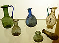
Miniature bottles for cosmetics and medicine (1st century)
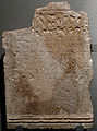
Gravestone
AE 2004, 00983
,_Gelduba_Grab_4756,_Museum_Burg_Linn.jpg)
,_Museum_Burg_Linn.jpg)
,_Gelduba_Grab_5555,_Museum_Burg_Linn.jpg)
_Museum_Burg_Linn.jpg)


_Museum_Burg_Linn.jpg)

See also
literature
- Renate Pirling : A Franconian princely grave from Krefeld-Gellep . In: Germania 42, De Gruyter, Berlin 1964, pp. 188-216.
- Wilhelm Piepers & Dorothea Haupt: Gelduba. The excavations in 1954/55 . In: Rheinische Ausgrabungen 3, Rheinland-Verlag Cologne, Bonn 1968, pp. 213-315.
- Ilse pair , Christoph B. Rüger : Fort Gelduba . In: Rhenish excavations. 10, Rheinland-Verlag, Düsseldorf 1971, pp. 242-339. (Contributions to the archeology of the Roman Rhineland 2).
- Renate Pirling: The Roman-Franconian cemetery of Krefeld-Gellep . Steiner, Berlin 1974 (= Germanic Monuments of the Migration Period, Series B, The Franconian Antiquities of the Rhineland Volume 8).
- Ilse Paar, Christoph B. Rüger: Recent excavations in the Roman fort Gelduba in Krefeld-Gellep . In: Rhenish excavations '76. Rheinland-Verlag Cologne, Bonn 1977, pp. 101-104.
- Renate Pirling: The excavations in Krefeld-Gellep . In: Excavations in the Rhineland '77. Rheinland-Verlag Köln, Bonn 1978, pp. 136–140.
- Renate Pirling: The Roman-Franconian cemetery of Krefeld-Gellep . de Gruyter, Berlin 1979 (= Germanic monuments of the migration period, series B, The Franconian antiquities of the Rhineland, Volume 10).
- Ilse Paar: To date the wooden construction periods of the Lower Germanic auxiliary fort Gelduba (Krefeld-Gellep). Excavations 1970-76 . In: William S. Hanson, Lawrence JF Keppie (eds.): Roman Frontier Studies 1979. Vol. II, BAR Int. Ser. 71 (1980), pp. 515-529.
- Renate Pirling: Romans and Franks in Krefeld-Gellep. Zabern, Mainz 1986, ISBN 3-8053-0893-0 .
- Renate Pirling: New excavations on the cemetery of Krefeld-Gellep. In: Villages and Cities. Excavations in the Rhineland 1985/86. Rheinland-Verlag Köln, Bonn 1987, pp. 57-60.
- Renate Pierling: Krefeld-Gellep. The burial grounds. In: Heinz-Günter Horn (Ed.): The Romans in North Rhine-Westphalia. Licensed edition of the 1987 edition. Nikol, Hamburg 2002, ISBN 3-933203-59-7 , pp. 534-536.
- Renate Pirling: A Sarmatian mirror from Krefeld-Gellep. In: Germania 66, 1988, pp. 455-468.
- Renate Pirling: The Roman-Franconian cemetery of Krefeld-Gellep . Steiner, Stuttgart 1989 (= Germanic monuments of the migration period, series B, The Franconian antiquities of the Rhineland, Volume 13).
- Renate Pirling: Two cult scissors from Krefeld-Gellep . In: Hansgerd Hellenkemper , Heinz Günter Horn (Hrsg.): Archeology in North Rhine-Westphalia. History in the heart of Europe . Zabern, Mainz 1990, pp. 231-232.
- Renate Pirling, Margareta Siepen: The Roman-Franconian burial ground of Krefeld-Gellep 1975–1982 . Steiner, Wiesbaden 1997, ISBN 3-515-06916-X (= Germanic monuments of the migration period, series B, The Franconian antiquities of the Rhineland, Volume 17).
- Renate Pirling, Margareta Siepen: The Roman-Franconian burial ground of Krefeld-Gellep 1983–1988 . Steiner, Stuttgart 2000, ISBN 3-515-07453-8 (= Germanic monuments of the migration period, series B, The Franconian antiquities of the Rhineland, Volume 18).
- Renate Pirling, Margareta Siepen: The Roman-Franconian burial ground of Krefeld-Gellep 1989–2000 . Steiner, Stuttgart 2003, ISBN 3-515-07974-2 (= Germanic monuments of the migration period, series B, The Franconian antiquities of the Rhineland, Volume 19).
- Renate Pirling, Margareta Siepen: The finds from the Roman graves of Krefeld-Gellep: Catalog of the graves 6348–6361. Steiner, Stuttgart 2006, ISBN 978-3-515-08891-6 (= Germanic monuments of the migration period, series B, The Franconian antiquities of the Rhineland, Volume 20).
- Christoph Reichmann: Krefeld-Gellep. Roman auxiliary fort. In: Heinz-Günter Horn (Ed.): The Romans in North Rhine-Westphalia. Licensed edition of the 1987 edition. Nikol, Hamburg 2002, ISBN 3-933203-59-7 , pp. 529-534.
- Christoph Reichmann: Krefeld-Gellep. The vicus. In: Heinz-Günter Horn (Ed.): The Romans in North Rhine-Westphalia. Licensed edition of the 1987 edition. Nikol, Hamburg 2002, ISBN 3-933203-59-7 , p. 534.
- Christoph Reichmann: The late antique fortifications of Krefeld-Gellep . Archäologisches Korrespondenzblatt 17 (1987), pp. 507-521.
- Christoph Reichmann: Gellep and the legend of the martyrdom of the Theban Legion . In: Gundolf Precht and Hans-Joachim Schalles (eds.): Trace reading. Contributions to the history of the Xanten area . Rheinland-Verlag Cologne, Bonn 1989, pp. 215-234.
- Christoph Reichmann: Gelduba in the 4th century . In: Clive Bridger & Karl-Josef Gilles (Hrsg.): Late Roman fortifications in the Rhine and Danube provinces . BAR Int. Series 704 (1998), pp. 23-34.
- Frank Siegmund: Merovingian time on the Lower Rhine . Rhenish excavations 34th Rheinland-Verlag, Cologne 1998, ISBN 3-7927-1247-4 .
- Paul Stüben: Gelduba. Vol. 1: The sunken city on the river . Selecto, Krefeld 1993, ISBN 3-923140-63-0 .
- Paul Stüben: Gelduba. Vol. 2: Your lost tracks on the river . Selecto, Krefeld 1995, ISBN 3-923140-68-1 .
- K. Hans Wedepohl, Renate Pirling and Gerald Hartmann: Roman and Franconian glasses from the Krefeld-Gellep burial ground . In: Bonner Jahrbücher, Volume 197, Rheinland-Verlag, Cologne 1997, ISSN 0938-9334 , pp. 177-189.
- Michael Cell: The Roman wall and ceiling paintings in Gelduba . Archaea, Gelsenkirchen 2006, ISBN 3-89972-700-2 .
Web links
- Geduba Castle
- Excavation history
- Julianus Egidius Bogaers : Auxiliaria. In: Files of the XI. International Limes Congress. Budapest 1978, pp. 606-610. PDF (reflections on epigraphic finds from Gelduba)
- Animated film Fort Gelduba
- Archeology in Krefeld
Individual evidence
- ↑ Pliny: Naturalis historia 19, 90.
- ↑ Tacitus: Historiae 4, 26, 32-33, 35-36, 58.
- ^ Itinerarium Antonini 255, 3.
- ^ Bernhard Moller: Rhenus Et Eius Descriptio Elegans. A Primis Fontibvs Vsqve Ad Oceanvm Germanicum. Vbi Vrbes, Castra, et Pagi adiacentes, Item Flumina et riuuli in hunc influentes, et si quid praetereà memorabile occurrat plenissimè carmine Elegiaco depingitur. Birckmannus, Cologne 1571.
- ^ A b c Renate Pirling: History of archaeological research in Krefeld .
- ^ Heinrich Wilhelm Herbertz: The village of yellow. In: The home. Krefeld yearbook. 67, p. 42 ff.
- ^ Anton Rein: Gelduba, today's Gellep or Yellow, and the next Roman fort on the Rhine . Krefeld 1851; Anton Rein: The Roman stations and roads between Colonia Agrippina and Burginatium and their as yet unpublished antiquities . Krefeld 1857.
- ↑ Franz Stollwerck: The celtubisch-Roman settlement Gelduba between Novaesium and Asciburgium. Self-published, Uerdingen 1877.
- ↑ a b c d lecture Gelduba by Robert Fahr 2011. Retrieved on August 1, 2014 .
- ^ Renate Pirling: Romans and Franks in Krefeld-Gellep . Zabern, Mainz 1986, ISBN 3-8053-0893-0 , p. 9.
- ↑ Margareta Siepen: Extraordinary horse harness from Gellep (PDF; 132 kB) . On archaeologie-krefeld.de, also in: Rheinisches Amt für Bodendenkmalpflege (Hrsg.): Archäologie im Rheinland 2007 .
- ^ Renate Pirling: Romans and Franks in Krefeld-Gellep . Zabern, Mainz 1986, ISBN 3-8053-0893-0 , pp. 32-35.
- ^ Tacitus: Historien 4, 57.
- ^ Renate Pirling: Romans and Franks in Krefeld-Gellep. Zabern, Mainz 1986, ISBN 3-8053-0893-0 , p. 21.
- ↑ Feinendegen / Vogt (ed.): Krefeld - the history of the city, volume 1. Chr. Reichmann - Chapter III: Roman times - up to the Bataverschlacht / p. 116f, Verlag van Ackeren, Krefeld 1998, ISBN 3-9804181-6- 2
- ↑ a b c Feinendegen / Vogt (Hrsg.): Krefeld - the history of the city, Volume 1. Chr. Reichmann - Chapter III: Roman times - the Roman conquests / p. 102-174, Verlag van Ackeren, Krefeld 1998, ISBN 3 -9804181-6-2
- ↑ Scale specifications, descriptions and sketches in the Linn Museum
- ↑ a b Ilse Paar: Fort Gelduba - excavations 1971 / p. 1–3, Archeology Krefeld - magazine for Niederrheinische Heimatpflege 1971
- ↑ a b c Christoph Reichmann: Gelduba - the Roman fort in Krefeld-Gellep / Museum accompanying document - Chapter V: the older castles, p. 30f., Verlag Freunde des Museen Burg Linn e. V. Krefeld 2011
- ↑ Christoph Reichmann: Gelduba - the Roman fort in Krefeld-Gellep / accompanying document to the museum - Chapter VII: History of the occupations, page 50f., Verlag Freunde des Museen Burg Linn e. V. Krefeld 2011
- ↑ Feinendegen / Vogt (ed.): Krefeld - the history of the city, Volume 1. Chr. Reichmann - Chapter III: Roman times - the late Roman military district / p. 159-175, Verlag van Ackeren, Krefeld 1998, ISBN 3-9804181- 6-2
- ↑ Feinendegen / Vogt (ed.): Krefeld - the history of the city, volume 1. Chr. Reichmann - Chapter III: Roman times - the camp village / p. 134f, Verlag van Ackeren, Krefeld 1998, ISBN 3-9804181-6-2
- ^ Museum Center Burg Linn: Exhibits in the Museum Center - picture panels, time tables and models / Gellep-Gelduba , as of August 2014
- ↑ Feinendegen / Vogt (ed.): Krefeld - the history of the city, volume 1. Chr. Reichmann - Chapter III: Roman times - catastrophe of 259 / pp. 142–149f, Verlag van Ackeren, Krefeld 1998, ISBN 3-9804181- 6-2
- ↑ a b Feinendegen / Vogt (ed.): Krefeld - the history of the city, volume 1. Chr. Reichmann - Chapter III: Roman times - the late Roman military district / p. 149–175, Verlag van Ackeren, Krefeld 1998, ISBN 3- 9804181-6-2
- ^ Geographer of Ravenna 4:24.
- ↑ Feinendegen / Vogt (ed.): Krefeld - the history of the city, Volume 1. Chr. Reichmann - Chapter III: Roman times . Verlag van Ackeren, Krefeld 1998, ISBN 3-9804181-6-2 , pp. 132-175; see Ingo Runde: Xanten in the early and high Middle Ages. Tradition of legends - monastery history - becoming a town . Böhlau, Cologne a. a. 2003, ISBN 3-412-15402-4 , p. 142, note 331.
- ↑ Martin Friedenthal: To Trepitia - Drüpt . In: Bonner Jahrbücher 59, 1959. S. 189f.
- ↑ Feinendegen / Vogt (ed.): Krefeld - the history of the city, volume 1. Chr. Reichmann - Chapter III: Roman times / p. 44f, Verlag van Ackeren, Krefeld 1998, ISBN 3-9804181-6-2
- ↑ Christoph Reichmann: Gelduba - the Roman fort in Krefeld-Gellep / Museum accompanying document - Chapter VI: the late Roman fortress, p. 42f, Verlag Freunde des Museen Burg Linn eV Krefeld 2011
- ↑ Renate Pirling: The Roman-Franconian grave fields of Krefeld-Gellep / Museum accompanying document - Chapter VII: The princely grave, page 50f, Verlag Freunde des Museen Burg Linn eV Krefeld 2011
- ↑ Christoph Reichmann: Gelduba - the Roman fort in Krefeld-Gellep / Museum accompanying document - Chapter IV: Bataverschlacht, p. 18 f., Verlag Freunde der Museen Burg Linn e. V. Krefeld 2011
- ↑ Christoph Reichmann: Gelduba - the Roman fort in Krefeld-Gellep / accompanying document for the museum - Chapter IV: Bataverschlacht, p. 20 f., Verlag Freunde der Museen Burg Linn e. V. Krefeld 2011
- ↑ Christoph Reichmann: Gelduba - the Roman fort in Krefeld-Gellep / accompanying document to the museum - Chapter VI: the late Roman fortress, p. 64 f., Verlag Freunde der Museen Burg Linn e. V. Krefeld 2011
- ↑ Christoph Reichmann: Gelduba - the Roman fort in Krefeld-Gellep / accompanying document for the museum - Chapter VI: the late Roman fortress, p. 68 f., Verlag Freunde der Museen Burg Linn e. V. Krefeld 2011
- ↑ Feinendegen / Vogt (ed.): Krefeld - the history of the city, volume 1. Chr. Reichmann - Chapter III: Roman times / p. 149 f., Verlag van Ackeren, Krefeld 1998, ISBN 3-9804181-6-2
- ↑ Feinendegen / Vogt (ed.): Krefeld - the history of the city, volume 1. Chr. Reichmann - Chapter III: Roman times / p. 167 f., Verlag van Ackeren, Krefeld 1998, ISBN 3-9804181-6-2
- ↑ Feinendegen / Vogt (ed.): Krefeld - the history of the city, volume 1. Chr. Reichmann - Chapter III: Roman times / p. 173 f., Verlag van Ackeren, Krefeld 1998, ISBN 3-9804181-6-2

Lugdunum Batavorum (Brittenburg Castle) | Praetorium Agrippinae (Valkenburg Castle) | Matilo (Leiden-Roomburg Castle) | Albaniana (Alphen aan den Rijn Castle) | Nigrum Pullum (Alphen-Zwammerdam Fort) | Bodegraven Castle | Laurium (Fort Woerden) | Castle Op de Hoge Woerd (Fletio?) | Traiectum (Utrecht Castle) | Fectio (Bunnik-Vechten Fort) | Levefanum (Rijswijk Castle) | Mannaricium (Buren-Maurik Fort) | Carvo (Kesteren Fort) | Overbetuwe-Randwijk Castle | Overbetuwe-Driel Castle | Castra Herculis (Arnhem-Meinerswijk Castle) | Duiven-Loowaard Castle | Carvium (Rijnwaarden Fort) | Harenatium (Cleve cattle fort) | Quadriburgium (Qualburg Castle) | Steincheshof Castle | Burginatium (Altkalkar Fort) | Vetera I | Vetera II | Wesel-Büderich Fort | Alpen-Drüpt Castle | Calo | Asciburgium (Fort Moers-Asberg) | Small fort Werthausen | Gelduba (Krefeld-Gellep Castle) | Novaesium (Neuss legionary camp) | Small fort on the Reckberg | Durnomagus (Dormagen Fort) | Buruncum (Worringen Fort) | Apud Aram Ubiorum (Legion camp Cologne) | Divitia | Naval fort Alteburg | Wesseling Roman Camp | Bonnensia (Bonn legionary camp) | Rigomagus (Remagen Fort)