
Matilo
| Matilo | |
|---|---|
| Alternative name | Leiden-Roomburg Castle |
| limes | Lower Germanic Limes |
| Dating (occupancy) | A) 47 to 69 B) 71 to around 200 C) around 200 to around 260/276 |
| Type | Cohort fort Numeruskastell (?) |
| unit | A) unknown B.a) unknown B.b) Cohors I Lucensium pf Bc) Cohors XV Voluntariorum (?), Plus Numerus Exploratorum Batavorum (?) C) Numerus Exploratorum Batavorum , plus Cohors XV Voluntariorum (?) |
| Construction | A) wood-ground storage B.A) wood-ground storage B.B + c) stone fort C) stone fort |
| State of preservation | Reconstructed in loco |
| place | Leiden -Roomburg |
| Geographical location | 52 ° 9 '0 " N , 4 ° 31' 4" E |
| height | -1 m NAP |
| Previous | Albaniana (east-southeast) |
| Subsequently | Praetorium Agrippinae (northwest) |
| Upstream | Flevum (north) |

Matilo , the Roman fortress Leiden-Roomburg , was the ancient name of an auxiliary fort on the Lower Germanic Limes . The former military camp is located in what is now the Leiden residential district of Roomburg in the Dutch province of South Holland, immediately below its modern reconstruction.
location
In ancient times, the fort was located at a point where the Leithe flowed into the Oude Rijn from the northeast , the Zijl branched off from it to the north and the Corbulonis fossa connected to the river from the southwest . The Fossa Corbulonis was a canal that Gnaeus Domitius Corbulo , the legatus Augusti (envoy of Augustus = commander) had built in the Germania inferior military district during his term of office from the year 47. The Fossa Corbulonis led to the Nieuwe Maas and thus considerably shortened the longer and above all more dangerous shipping route across the North Sea. All these watercourses, as inconspicuous as they appear today, were navigable in Roman times for the boats used at that time. The fort, located slightly higher than the surrounding area, was therefore in an optimal position in terms of traffic and military geography. With its praetorial front, it was not aimed at the Rhine, but at the Corbulo Canal.
In today's settlement picture, the reconstructed fort is located in loco within an archaeological park in the Leiden residential district of Roomburg, between Leiderdorp in the east and the Vliet in the west.
Sources and research history
The linguistic origin of the name Matilo is unclear. On the Tabula Peutingeriana it is shown as Matilone between Albaniana (five leagues away) and Praetorium Agrippinae (three leagues away). The place is later mentioned under the name Matellionem in the Cosmographia of the anonymous geographer of Ravenna , created around the year 700 .
As early as the beginning of the 16th century, Roman finds were made on the site of the now defunct St. Margaretha der Tertiarissen monastery, which in the Middle Ages had settled directly northeast of the former fort area. Modern archaeological excavations began in 1927 with investigations by Jan Hendrik Holwerda . In 1962 Julianus Egidius Bogaers discovered a silted-up watercourse about 100 meters northwest of the fort, the banks of which were fortified and which ultimately turned out to be the Corbulonis fossa mentioned by Tacitus and Cassius Dio . In 1970 electrical ground resistance measurements were carried out on the fort grounds, on the basis of which control excavations were carried out in 1974 and from 1994 to 1999. A large-scale excavation was refrained from in view of the lack of a building threat in the area and taking into account the monument status (see below). With the results and findings from the measurements and the soundings, the defense and the position of the Principa could be reconstructed. The vicus , the camp's civilian settlement, was discovered and examined in the early 1970s.
History, findings, inscriptions and troops
1st century
Matilo was a garrison that was built in 47 or shortly after by Gnaeus Domitius Corbulo (see above) as a wood-earth warehouse as part of his border security measures. Very few traces could be identified from this time. Whether the fort was built on the site of an earlier watchtower or a road station, as Willem Albertus van Es had suspected, has not yet been proven. During the Batavian uprising in 69/70, the military camp, like almost all other Roman border forts, was destroyed.
The reconstruction took place in the year 71. After the uprising of Lucius Antonius Saturninus (89) the fort was expanded and strengthened either in the late Domitian or early Trajan times. This expansion was possibly the reason for the production of a consecration stone dated between 103 and 110 with the inscription:
G GER DACICO P
M RIB PPP COS V
COH III LUCENSIV PF
Reading: [Imp (eratori) Ca] e (sari) Nerva (e) Traia [no / Au] g (usto) Ger (manico) Dacico p (ontifici) / [m (aximo), t] rib (unicia) p (otestate), p (atri) p (atriae), co (n) s (uli) V / [coh (ors)] Lucensiu [m] P (ia) F (idelis).
Transmission: "To the emperor Caesar Nerva Traianus Augustus (with the honorary names) Germanicus Dacicus, supreme priest , holder of tribunician power , father of the fatherland , five times consul , from the cohort of Lucensis (with the honorary names) the faithful and loyal."
2nd and 3rd centuries
The fort of the second century was rectangular in shape and with its sides of around 82 by 100 m covered an area of 0.8 hectares. One eighth of this was taken up by the Principia (headquarters), which are 32 m square and cover an area of 1024 square meters. The walls and, of the internal structures, at least the principia were now made of stone. The previous simple trench has been replaced by a triple trench system. A renovation measure can be assumed for the year 123, when the traffic routes and many forts of the Lower Germanic Limes were repaired on the occasion of a visit by Emperor Hadrianus . The time towards the end of the second and beginning of the third century is more tangible, from which there are three inscriptions that can be dated between 196 and 205.
The most recent epigraphic evidence is a building inscription from the years 196 to 198:
VS AVG ET M AVRELIVS ANTONIN
VS CAES COH XV VOL ARMA
MENTARIVM VETVSTATE CONLA
BSVM RESTITVERVNT SVB VAL PV
DENTE LEG AVG PR PR CVRA ET CAECIL BATONE PRAE
PRE
Reading: Imp (erator) Caes (ar) L (ucius) Septimius Sever / us Aug (ustus) et M (arcus) Aurelius Antonin / us Caes (ar) coh (ortis) XV Vol (untariorum) arma / mentarium vetustate conla / bsum restituerunt sub Val (erio) Pu / dente leg (ato) Aug (usti) pr (o) pr (aetore) cura (nte) et Caecil (io) Batone prae (posito) // Pre.
Transfer: "Emperor Caesar Lucius Septimius Severus Augustus and Marcus Aurelius Antoninus Caesar restored the old-collapsed armory of the 15th volunteer cohort under the care of Valerius Pudens, legate of the Augusti in the rank of propraetor, and the commander Caecilius Bato."

The second stone monument dates from 198 to 205:
M AVRELLIVS ANTONINVS AVGG
NVMERO EXPL BAT CVR Q VENIDIO RVF LEG AVGG PR PR
Reading: Impp (eratores) Caess (ares) L (ucius) Septimius Severus Pius Pert [inax et] / M (arcus) Aurellius Antoninus Augg (usti) et L (ucius) Sept (imius) Geta Caesar d (ecreto) d ( ecurionum)] / numero expl (oratorum) Bat (avorum) cur (ante) Q (uinto) Cu (i) o Venidio Ruf [o leg (ato) Augg (ustorum) pr (o) pr (aetore)].
Transmission: "The emperors and Caesars Lucius Septimius Severus Pius Pertinax and Marcus Aurelius Antoninus, the Augusti, and Lucius Septimius Geta, Caesar , (give this) by decree of the decurions to the number of Batavian scouts under the care of Quintus Venidius Rufus, the legate the emperor in the rank of propaetor. "
What is interesting about this inscription is that it contains a Damnatio memoriae , a "condemnation of memory". The name of Geta was demonstratively chiseled out after Caracalla had triumphed in the conflict with his brother and gained sole rule (end of 211).
Finally, the last inscription can be assigned to the years 200/201:
MAXIM TRIB POT VIII IMP CAES
M AVRELANTONINVS AVG PIVS PONTIF MAX
TRIB POT III L SEPTIMI SEV R PII PE AVG FIL
COH XV VOL CRPF
LEG AVGG PR PR PE VEXI
Reading: [Imp (erator) Caes (ar) L (ucius) Septimius Seve] rus Pius Pertinax Aug (ustus) / [pontifex] maxim (us) trib (unicia) pot (estate) VIII [et] Im [p (erator ) Caes (ar)] / [M (arcus) Aurel (lius) Antoninus] Aug (ustus) Pius pontif (ex) max (imus) / [trib (unicia) pot (estate) III] L (uci) Septimi Sev [ e] r [i] Pii Pe [rtinacis Aug (usti) fil (ius)] / coh (ors) XV vol (untariorum) c (ivium) R (omanorum) P (ia) F (idelis) / [le] g (atus) Augg (ustorum) pr (o) pr (aetore) pe [r] vexi (llarios).
Transfer: "Emperor Caesar Lucius Septimius Severus Pius Pertinax Augustus, pontifex maximus, in possession of tribucinic power for the eighth time, and Emperor Caesar Marcus Aurellius Antoninus Augustus Pius, pontifex maximus, endowed with tribunic power for the third time, son of Lucius Septimius Severus Pius Pertinax Augustus, (did this) for the 15th cohort of voluntary Roman citizens, with the honorary name the faithful and loyal (given), (while) the legate of Augusti in the office of propraetor (took care of the execution) for the Vexilliarier (took care of ). "
Nothing is known about the end of the camp. But one can assume that it took place in connection with the increasing Franconian pressure at the end of the third quarter of the third century and that the fort was destroyed during one of the great Franconian advances around 260 or at the latest around 275/276 or was abandoned afterwards, as At that time it happened almost everywhere on the northern section of the Lower Germanic Limes.
troops
Due to the impressive inscriptions, which were limited to two narrow periods of time, as well as the large-scale archaeological excavation that was not carried out and the corresponding lack of results, the occupation history of the garrison can only be reconstructed with some certainty. While nothing is known about the fort crews during most of the first century, the Cohors I Lucensium pia fidelis is documented from the turn of the first to the second century , a Cohors equitata (partially mounted cohort) of around six hundred men, originally in the Spanish Gallaecia region had been excavated. It cannot have been stationed in Matilo a long time before, as it is still documented in the years 88 and 90 in the province of Syria , where it appears again in inscriptions for 153. However, it cannot be ruled out that she was already in Matilo for a short time before her mission in Syria, as she is listed as a troop stationed in Germania on a military diploma dated 81/85.
The Cohors XV Voluntariorum , a pure infantry cohort of 480 men, whose presence in Matilo is evidenced not only by the stone inscription described above, but also by a number of brick stamps has been documented for the end of the second and beginning of the third century . The problem is that this cohort, which was excavated after the Clades Variana and operated in Lower Germany for the time of its existence, is also inscribed in Praetorium Agrippinae ( Valkenburg ), Nigrum Pullum ( Alphen aan den Rijn -Zwammerdam) and in Laurium ( Woerden ) appears. It is not clear whether she switched between these locations, distributed vexillations to the individual locations or maybe even only transported her bricks to other locations and which was her own or at least main location.
The Numerus Exploratorum Batavorum , with an inscription for the same period, was a mixed association of infantry and cavalry, the strength of which was probably higher than that of an ordinary Numerus . It is possible that the numerus remained in Matilo for a long time, its presence in Germania at least is attested for the year 239 by a consecration stone found in Cologne.
Vicus
As with all other permanent types of Roman garrison, a vicus extended around the fort in Matilo. The vicus was a civil settlement where veterans, relatives of soldiers, traders, craftsmen, prostitutes, innkeepers and other service providers settled. The vicus of Matilo is thought to have been home to around 500 people. It continued on the far bank of the Fossa Corbulonis, where it formed a kind of bridgehead, to which it was probably connected by a simple wooden bridge. In any case, rows of wooden piles that were found during the investigations and led from the bank into the center of the canal speak in favor of this.
presentation
Finds from Matilo in the Rijksmuseum van Oudheden in Leiden
Over the centuries, a large number of finds from the castle, the civil settlement and the cemetery of Matilo came to light from the Roomburger earth, including some unique pieces. The outstanding objects are exhibited in the Rijksmuseum van Oudheden in Leiden.
- Selected finds from Matilo

Equestrian mask,
end of the 1st century
FO: Fossa Corbulonis
AO Rijksmuseum van Oudheden, Leiden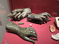
Bronze hands of statues, front from Matilo, back left from Forum Hadriani, back right from Hoogwerf, Naaldwijk
FO: Matilo
AO: Rijksmuseum van Oudheden, Leiden
Escape tablets (used to curse other people), 2nd or 3rd century
FO: Matilo
AO: Rijksmuseum van Oudheden, Leiden
Clay statuette of a goddess, possibly Venus or a river goddess, 150–175
FO: Matilo
AO: Rijksmuseum van Oudheden, Leiden
Cooking pot made of rough-walled earthenware with cremation remains
FO: Vicus Matilo
AO: Rijksmuseum van Oudheden, Leiden


Matilo Archaeological Park
In 2010, by means of a council resolution, the municipality of Leiden began implementing plans to build an archaeological park on the former fort grounds. The corresponding work took place in the following years and was completed in 2013. Great care was taken when creating the park so as not to damage the monument beneath it. There were no interventions in the ground, inside only two paths mark the course of Via praetoria (main warehouse street, arterial road), Via decumana (rear extension of Via praetoria) and Via principalis dextra (right half of the warehouse cross street) on the otherwise with Grassed area. The fence is marked by a heaped earth wall, on which a row of cornifers symbolize the course of the former wooden palisade and later wall. The park is a recreation area for the adjacent residential areas and is also used for occasional events.

Reconstructed east gate from the outside

Interior of the camp, view towards the east gate

Reconstructed west gate from the inside

Reconstructed west gate from the outside with a hint of the Corbulo Canal in the foreground (low wall)
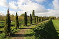
Enclosure planted with cornifers. The trees are supposed to symbolize the palisade.


Monument protection
The areas with the Roman remains are protected as ground monuments according to the Dutch monument law ( monumentenwet ) of 1988 . The former fort area (and that of the medieval monastery) was named Rijksmonumenten (German: "Reichsmonument" in the sense of national monument ) under number 45576, the Corbulokanal and the areas of the Roman vicus under number 531040 .
See also
literature
- Julianus Egidius Bogaers : Leiden-Roomburg - Matilo. In: Julianus Egidius Bogaers, Christoph B. Rüger : The Lower Germanic Limes. Materials on its story . Rheinland-Verlag, Cologne 1974, ISBN 3-7927-0194-4 , pp. 44-45.
- Chrystel R. Brandenburgh, Wilfried AM Hessing: Matilo - Rodenburg - Roomburg. De roomburgerpolder: van Romeins castellum dead modern woonwijk. Floor shade en bouwgeheimen . Part 1, Gemeente Leidenk, Dienst bouwen en wonen, Leiden, 2005.
- Chrystel R. Brandenburgh, KM van der Harst-van Domburg: Een archeologische onderzoek in de randzone van de vicus van Matilo, Roomburg 2004 fase 2 . Gemeente Leiden, Dienst Bouwen en Wonen, Bureau Monuments en Archeologie, Leiden 2008.
- Chrystel R. Brandenburgh, J. de Bruin: Met de voeten in het water. Archeologically onderzoek aan de oostzijde van castellum Matilo te Leiden . 2016.
- Killian Cramers: Het Romeinse kamp Matilo in Leiden en de Fossa Corbulonis . Katholieke Universiteit Leuven, Leuven 2016, (digitized version)
- Evert van Ginkel, Wouter Vos: Grens van het Romeinse Rijk. De Limes in Zuid-Holland . Matrijs, Utrecht 2018, ISBN 978-90-5345-531-9 .
- Jan Kees Haalebos , Willem JH Willems : Leiden-Roomburg and the cohors XV Voluntariorum. In: Dies .: The Lower Germanic Limes in the Netherlands, 1995–1997. In: N. Gudea (Ed.): Roman Frontier Studies. Proceedings of the 17th International Congress of Roman Frontier Studies . (1999), pp. 77-87, here pp. 78f. (also (digitized) )
- Tom Hazenberg, Marinus Polak: Leiden-Roomburg 1995–1997. Archeologically onderzoek naar het kanaal van Corbulo en de vicus van het castellum Matilo . Rijksdienst voor het Oudheidkundig Bodemonderzoek, 2000.
- Wilfried AM Hessing: The Dutch coastal area. In: Tilmann Bechert , Willem J. H. Willems (Hrsg.): The Roman border between the Moselle and the North Sea coast . Theiss, Stuttgart 1995, ISBN 3-8062-1189-2 , p. 93.
- Laura Immy Kooistra: Remnants of planets in the edge zone van de vicus bij Matilo (Leiden-Roomburg) . BIAX Consult, Zaandam 2005.
- Els Lems: Op zoek naar Matilo. Spurs van de Romeinen in Leiden . Leids verleden No. 6 (1995), Gemeente Leiden, Dienst bouwen en wonen, Leiden 1995.
- Annemarie Luksen-IJtsma: De limesweg in West-Nederland. Inventory, analysis and synthesis of archeological onderzoek naar de Romeinse weg tussen Vechten en Katwijk. Basic report archeology 40 . Cultuurhistorie, gemeente Utrecht, Utrecht 2010, ISBN 978-90-73448-41-4 .
- JAM Oude Rengerink: Archeological booronderzoek op vier terreindelen in het plangebied Roomburg Matilo te Leiden . RAAP report 92 (1994).
- Marinus Polak, J. van Doesburg, PAMM van Kempen: Op zoek naar het castellum Matilo en het St. Margarethaklooster te Leiden-Roomburg. Het archeologische onderzoek in 1999-2000. Rijksdienst voor het Oudheidkundig Bodemonderzoek, Amersfoort 2004.
Web links
- Archeological Park Matilo , official website of the Archaeological Park Matilo (Dutch), accessed on November 26, 2018
- Matilo (Leiden-Roomburg) on the website of the historian Jona Lendering (English), accessed on November 26, 2018
Remarks
- ↑ The lettering ANTONIA ANORVM between the second and third lines was added later.
- ↑ FO = place of discovery
- ↑ AO = storage location
- ↑ Texts and symbols harmful to the person to be cursed were written on the board. The panel was then rolled up into a tube and buried in a selected, convenient location.
- ↑ Water flows down from the column on which the right hand rests.
- ↑ Normal cooking pots were also used for burial purposes.
Individual evidence
- ↑ a b CIL 13, 8823
- ↑ CIL 13, 08824 and CIL 13, 08826 and AE 1999, 1101
- ↑ a b CIL 13, 8825
- ^ Menno FP Dijkstra: Rondom de Mondingen van Rijn & Maas. Landschap en bewoning tussen de 3e to 9e eeuw in Zuid-Holland, in het bijzonder de Oude Rijnstreek . Sidestone Press, Leiden 2011, ISBN 978-90-8890-078-5 , pp. 40-48.
- ^ A b Wilfried AM Hessing: The Dutch coastal area. In: Tilmann Bechert, Willem J. H. Willems (Hrsg.): The Roman border between the Moselle and the North Sea coast . Theiss, Stuttgart 1995, ISBN 3-8062-1189-2 , p. 93.
- ↑ Tab. Peut., Segm. II 2.
- ↑ Anon. Rav. 4.24.7.
- ^ Julianus Egidius Bogaers: Leiden-Roomburg - Matilo. In: Julianus Egidius Bogaers, Christoph B. Rüger: The Lower Germanic Limes. Materials on its story . Rheinland-Verlag, Cologne 1974, ISBN 3-7927-0194-4 , p. 44.
- ↑ a b Rijksmonument 45575: Terrein waarin overblijfselen van het Romeinse castellum Matilone en van het Middeleeuwse klooster van St. Margaretha der Tertiarissen OLV in Jeruzalem tot St. Margarethenberch in the official monument directory of the Rijksdienst voor het Cultureel Erfgoed (Dutch), accessed on November 27th, 2018.
- ^ Jan Hendrik Holwerda: Matilo . In Mededelingen uit het Rijksmuseum van Oudheden te Leiden , 8 (1927), pp. 60-67.
- ↑ Tac. Ann. XI, 20.
- ^ Cass. Dio 60.30.
- ↑ Tom Hazenberg, Marinus Polak: Leiden-Roomburg 1995-1997. Archeologically onderzoek naar het kanaal van Corbulo en de vicus van het castellum Matilo . Rijksdienst voor het Oudheidkundig Bodemonderzoek, 2000, pp. 10-15.
- ^ Willem Albertus van Es: De Romeinen in Nederland . Haarlem 1972, p. 100.
- ↑ CIL 13, 08824
- ↑ RMD-05, 00327
- ↑ Agustín Jiménez de Furundarena: Cohors I Lucensium Equitata. In: Hispania Antiqua XL. (2016), pp. 169–190, (digitized version )
- ^ Jan Kees Haalebos, Willem JH Willems: Leiden-Roomburg and the cohors XV Voluntariorum. In: Dies .: The Lower Germanic Limes in the Netherlands, 1995–1997. In: N. Gudea (Ed.): Roman Frontier Studies. Proceedings of the 17th International Congress of Roman Frontier Studies . (1999), p. 78f., (Digitized version)
- ↑ AE 1990, 00728
- ↑ Marcus Reuter : Studies on the numeri of the Roman army in the Middle Imperial period. In: Reports of the Roman-Germanic Commission. 80, 1999, pp. 432-436.
- ↑ a b Archeological Park Matilo , official website of the Archaeological Park Matilo (Dutch), accessed on November 28, 2018.
- ^ Evert van Ginkel, Wouter Vos: Grens van het Romeinse Rijk. De Limes in Zuid-Holland . Matrijs, Utrecht 2018, ISBN 978-90-5345-531-9 , p. 19.
- ^ Text of Monumentenwet 1988 on a government website for the publication of legal texts (Dutch), accessed on November 27, 2018.
- ↑ Rijksmonument 531040: Terrein waarin sporen van het kanaal van Corbulo en kampdorp uit de Romeinse tijd en mogelijke bewoningssporen uit de Vroege Middeleeuwen in the official monument directory of the Rijksdienst voor het Cultureel Erfgoed (Dutch), accessed on November 27, 2018.

Lugdunum Batavorum (Brittenburg Castle) | Praetorium Agrippinae (Valkenburg Castle) | Matilo (Leiden-Roomburg Castle) | Albaniana (Alphen aan den Rijn Castle) | Nigrum Pullum (Alphen-Zwammerdam Fort) | Bodegraven Castle | Laurium (Fort Woerden) | Castle Op de Hoge Woerd (Fletio?) | Traiectum (Utrecht Castle) | Fectio (Bunnik-Vechten Fort) | Levefanum (Rijswijk Castle) | Mannaricium (Buren-Maurik Fort) | Carvo (Kesteren Fort) | Overbetuwe-Randwijk Castle | Overbetuwe-Driel Castle | Castra Herculis (Arnhem-Meinerswijk Castle) | Duiven-Loowaard Castle | Carvium (Rijnwaarden Fort) | Harenatium (Cleve cattle fort) | Quadriburgium (Qualburg Castle) | Steincheshof Castle | Burginatium (Altkalkar Fort) | Vetera I | Vetera II | Wesel-Büderich Fort | Alpen-Drüpt Castle | Calo | Asciburgium (Fort Moers-Asberg) | Small fort Werthausen | Gelduba (Krefeld-Gellep Castle) | Novaesium (Neuss legionary camp) | Small fort on the Reckberg | Durnomagus (Dormagen Fort) | Buruncum (Worringen Fort) | Apud Aram Ubiorum (Legion camp Cologne) | Divitia | Naval fort Alteburg | Wesseling Roman Camp | Bonnensia (Bonn legionary camp) | Rigomagus (Remagen Fort)