Rio Piracicaba (Rio Doce)
| Rio Piracicaba | ||
|
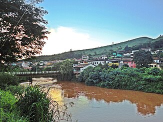
The Rio Piracicaba in Rio Piracicaba municipality. |
||
| Data | ||
| location | Brazil , State of Minas Gerais | |
| River system | Rio Doce | |
| Drain over | Rio Doce → Atlantic Ocean | |
| source | Serra do Caraça near Ouro Preto | |
| Source height | 1680 m | |
| muzzle | in Ipatinga in the Rio Doce Coordinates: 19 ° 29 ′ 32 ″ S , 42 ° 30 ′ 53 ″ W 19 ° 29 ′ 32 ″ S , 42 ° 30 ′ 53 ″ W. |
|
| Mouth height | 235 m | |
| Height difference | 1445 m | |
| Bottom slope | 6 ‰ | |
| length | 241 km | |
| Catchment area | 6000 km² | |
The Rio Piracicaba is a river in the Brazilian state of Minas Gerais, 150 miles long . It rises at an altitude of 1680 m near Ouro Preto and flows through several places where the steel industry is located, such as Barão de Cocais , João Monlevade with Belgo-Mineira , Timóteo with Arcesita and Ipatinga with Usiminas . Accordingly, it is a river heavily polluted with industrial wastewater.
It drains the Vale do Aço and flows into the Rio Doce in Ipatinga .
Individual evidence
- ↑ a b c d Comitê da Bacia Hidrográfica do Rio Piracicaba: Informações gerais sobre a Bacia do Rio Piracicaba ( Memento of the original from March 1, 2010 in the Internet Archive ) Info: The archive link was inserted automatically and has not yet been checked. Please check the original and archive link according to the instructions and then remove this notice. , visited on May 30, 2010.
Web links
Commons : Piracicaba River (Minas Gerais) - Collection of images, videos and audio files
