Rio Vermelho (Araguaia)
| Rio Vermelho | ||
|
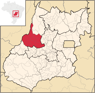
The Rio Vermelho flows in the middle through the microregion of the same name, shown in red on the map, from southeast to northwest. |
||
| Data | ||
| location | State of Goiás , Brazil | |
| River system | Rio Tocantins | |
| Drain over | Rio Araguaia → Rio Tocantins → Rio Pará (Amazon Delta) → South Atlantic | |
| source | east of Goiás Velho | |
| muzzle | in Aruanã in the Rio Araguaia Coordinates: 14 ° 55 '36 " S , 51 ° 5' 23" W 14 ° 55 '36 " S , 51 ° 5' 23" W. |
|
| Height difference | 523 m | |
| Bottom slope | 1.9 ‰ | |
| length | 282 km | |
| Catchment area | 12,630 km² | |
| Left tributaries | Rio Uvá, Rio Itapirapuã, Ribeirão da Áqua Limpa | |
| Right tributaries | Rio Bugre, Rio Ferreira | |
| Communities | Goiás Velho , Itapirapuã , Matrinchã , Britânia , Aruanã | |
| Residents in the catchment area | approx. 90,000 | |
| Ports | Aruanã | |
|
Near the source in Goiás Velho |
||
The Rio Vermelho (literally "Red River") is a right tributary of the Rio Araguaia in Brazil in the state of Goiás in the microregion Rio Vermelho .
River course
The spring is located 17 km east of the old Brazilian city of Goiás Velho , through which it flows. After leaving this headwaters, the Rio Vermelho is a border water between Itapirapuã and Matrinchã and between Britânia and Aruanã . The river flows into the Rio Araguaia about 230 km south of the Ilha do Bananal near Aruanã as the crow flies .
Tributaries
| Left tributaries | Right tributaries |
|
|
See also
Individual evidence
- ↑ a b Systema National de Informações Sobre Recursos Hídrico (SNIRH 2009), page V.II-13 ( page no longer available , search in web archives ) Info: The link was automatically marked as defective. Please check the link according to the instructions and then remove this notice. , PDF file, ( port. ); Accessed: August 11, 2012
- ↑ a b Map of Goiás ( Memento of the original from December 17, 2011 in the Internet Archive ) Info: The archive link was automatically inserted and not yet checked. Please check the original and archive link according to the instructions and then remove this notice.

