River Adur
| River Adur | ||
|
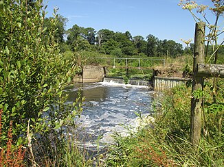
Weir near Shermanbury |
||
| Data | ||
| location | Adur District , West Sussex , England | |
| River system | River Adur | |
| River basin district | South east | |
| origin | Confluence of the West and East Arms north of Henfield 50 ° 57 ′ 46 ″ N , 0 ° 14 ′ 9 ″ W |
|
| muzzle | at Shoreham-by-Sea in the English Channel Coordinates: 50 ° 49 ′ 36 ″ N , 0 ° 14 ′ 53 ″ W 50 ° 49 ′ 36 ″ N , 0 ° 14 ′ 53 ″ W
|
|
| Small towns | Steyning | |
The River Adur is a river in West Sussex , England after which the Adur district is named.
River course
In the upper reaches of the Adur is divided into the West Arm and the East Arm . The western course of the river has its source at Slinfold and flows through Shipley and West Grinstead . The eastern Adur has its source at Ditchling Common and flows between Haywards Heath and Burgess Hill . At Henfield the two rivers unite and flow through the Adur valley towards the lake. The estuary is at Shoreham-by-Sea .
shipping
In the past, the river was navigable up to Steyning , where there is a harbor, also for larger ships. Due to silting, economic use is no longer possible today. For this reason, a larger port was built downstream at Shoreham-by-Sea , which is still an important transshipment point for wood, oil and gravel extracted from the sea.
tourism
The Adurtal was as Area of Outstanding Natural Beauty (dt .: Area of Outstanding Natural Beauty ) classified and is not the only way for walking, cycling and horse riders Their very popular. In addition, the river itself is popular with windsurfers and rowers.
particularities
The first take-off of the Avro 503 , a biplane aircraft made by the British manufacturer Avro , took place on May 28, 1913 on the River Adur.
