Steyning
| Steyning | |||
|---|---|---|---|
|
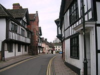
 Old town of Steyning |
||
| Basic data | |||
| status | Town and Civil Parish | ||
| surface | 15.741 km² | ||
| population | 5990 (as of 2011) | ||
| Ceremony county | West Sussex | ||
| District | Horsham District | ||
| Constituency | Arundel and South Downs | ||
| Website: steyningpc.gov.uk | |||
Steyning is a small town ( Town ) and a Civil Parish in Horsham District in West Sussex , England . The parish is north of the South Downs near the River Adur . Steyning forms a built-up area with the neighboring communities of Bramber and Upper Beeding .
history
The history of Steyning goes back to Anglo-Saxon times. According to the legend, St. Cuthmann built a church at the place where he settled after a trip with his mother, whom he transported in a wheelbarrow. The later city of Steyning developed around this church.
However, it is documented that Edward the Confessor promised the Church of Steyning to the Norman Abbey of Fécamp (France) in gratitude for granting him refuge during his exile . However, the Count of Wessex, Godwin and later his son, King Harald , tried to drive the Norman monks out of Steyning because they feared that this could prove dangerous in the event of a Norman invasion. William the Conqueror then swore to retake Steyning for the monks and, after the successful invasion of 1066, confirmed the donation in a charter :
Confirming the gift, made by Edward the Confessor, of Steyning. This charter acquitted the grantees of all earthly service and subjection to barons, princes, and others, and gave them all royal liberties, custom, and justice over all matters arising in their land; and threatened any who should infringe these liberties with an amercement of £ 100 of gold.
Even at that time, Steyning was a lively and important trading center in the region and even housed its own royal mint. The steady increase in importance of Steyning, however, was severely dampened when Wilhelm the Conqueror awarded the lands around Bramber to his loyal William de Braose . Shortly thereafter, he built Bramber Castle and a bridge over the Adur River . At this bridge he demanded a toll from the ships that wanted to go to the port of Steyning upstream. He also had violent border disputes with the monks at Steyning and refused to have Bramber's dead buried in the cemetery in Steyning. In 1086 the monks therefore called the king for help and the king decided in a major court case that William de Braose should reduce his bridge tariffs, refrain from encroaching on the Steyning lands and transfer the dead from Bramber to Steyning.
Despite the royal decision, there were always disputes between Bramber and Steyning. With the gradual silting of the river, the associated decline of Steyning in the 14th and the retreat of the monks in the 15th century, the disputes became less important. During this time the church at Steyning was renamed from St. Cuthman's Church to St. Andrew's Church .
Although Steyning lost its importance, the place continued to exist. In 1614 William Holland, a city councilor from Chichester Steyning founded a secondary school, the Steyning Grammar School , which still exists today. In 1861 Steyning was connected to the national railway network. Due to the lack of importance, the route was closed in 1966 and converted into a cycle path, the Downs Link .
Steyning today
Today Steyning is a magnet for tourists because of its historic old town. In addition, there is a basic economic infrastructure with restaurants, banks and a modern leisure center. In addition, an annual spring market attracts guests during the spring break.
sons and daughters of the town
- George Coppin (1819–1906), actor, theater entrepreneur and politician
- Augusta Klein (1866–1943), writer
- Mike McKee (* 1933), racing driver and gallery owner
- Chris Carter (* 1942), middle distance runner
People related to Steyning
- Laurence Olivier (1907–1989), actor and director, had a country house near Steyning and died here
Web links
- About Steyning and surroundings (English)
- Steyning Grammar School (English)
Individual evidence
- ^ HWC Davis (Ed.): Regesta Regum Anglo-Normannorum 1066-1154. Oxford 1913
Coordinates: 50 ° 53 ′ N , 0 ° 20 ′ W

