
River Stour (North Sea)
| River Stour | ||
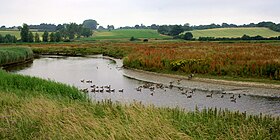
 River Stour at Manningtree , Essex |
||
| Data | ||
| location | Cambridgeshire , Essex , Suffolk , England | |
| River system | River Stour | |
| River basin district | South east | |
| origin | Wratting Common at Weston Colville , Cambridgeshire 52 ° 8 ′ 25 ″ N , 0 ° 23 ′ 36 ″ E |
|
| muzzle | at Harwich , Essex in the North Sea Coordinates: 51 ° 56 ′ 45 " N , 1 ° 20 ′ 45" E 51 ° 56 ′ 45 " N , 1 ° 20 ′ 45" E
|
|
| length | 76 km (47 miles) | |
| Left tributaries | River box , river board | |
| Right tributaries | Black Brook | |
| Medium-sized cities | Haverhill , Harwich | |
| Small towns | Sudbury , Nayland | |
| Communities | Clare, Bures, Higham, Dedham , Manningtree | |
The River Stour is a coastal river in East Anglia with a length of 76 km (47 miles). It is located in Cambridgeshire , Suffolk and Essex in the south-east of England and largely forms the border between the counties of Suffolk in the north and Essex in the south. It rises in the east of Cambridgeshire and flows into the North Sea at Harwich .
course
The river has its source in Wratting Common near Weston Colville, Cambridgeshire, touches the east of Haverhills , flows through Cavendish, Bures, Sudbury , Nayland, Stratford St Mary and Dedham first to the south and then to the east . It flows on through Dedham Vale , an Area of Outstanding Natural Beauty (AONB), through Manningtree in Essex and reaches the North Sea at Harwich. The tidal current extends to Manningtree.
Dedham Vale is the eastern area of the Stour, named after the town of Dedham in Essex. It is an “Area of Outstanding Natural Beauty” (AONB) on both sides of the Stour. Dedham Vale extends approximately 22 km (14 miles) in length from Dedham in the east to Wormingford in the west.
The area is also known as constable country , because the painter John Constable (1776–1837), who grew up in East Bergholt and Dedham, often described it in his pictures - as did Thomas Gainsborough and Paul Nash .

Dedham Vale at Manningtree
River Stour at Manningtree


literature
- Joseph Priestley: Historical Account of the Navigable Rivers, Canals, and Railways, of Great Britain. London 1831, pp. 597-598 ( online at Google Books )
Web links
Individual evidence
- ^ A b Environment Agency - River Stour . www.environment-agency.gov.uk. November 2006. Retrieved September 15, 2015.
- ^ River Stour Navigation . Retrieved September 15, 2015.