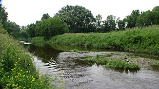
Rivière L'Acadie
| Rivière L'Acadie | ||
|
Rivière L'Acadie in Saint-Jean-sur-Richelieu , Québec |
||
| Data | ||
| location | Montérégie in Québec (Canada) | |
| River system | Saint Lawrence River | |
| Drain over | Rivière Richelieu → Saint Lawrence River → Atlantic Ocean | |
| source | at Hemmingford on the US border 45 ° 1 ′ 36 ″ N , 73 ° 35 ′ 25 ″ W |
|
| muzzle |
Rivière Richelieu Coordinates: 45 ° 29 ′ 1 ″ N , 73 ° 16 ′ 9 ″ W 45 ° 29 ′ 1 ″ N , 73 ° 16 ′ 9 ″ W.
|
|
| length | 82 km | |
| Discharge at the Autoroute 10 gauge ( ⊙ ) A Eo : 345 km²
|
MQ 1980/2000 Mq 1980/2000 |
4 m³ / s 11.6 l / (s km²) |
| Medium-sized cities | Chambly | |
| Small towns | Carignan | |
| Communities | Napierville | |
The Rivière L'Acadie is a left tributary of the Rivière Richelieu in the Montérégie administrative region of the Canadian province of Québec .
The Rivière L'Acadie rises in the hilly landscape of the municipality of Hemmingford not far from the border with the US state of New York . It flows mainly in a northerly direction. He crosses Autoroute 15 and Route 217 . It then flows through the parish of Napierville . The next 15 km follows route 219 along the east bank. The river later crosses Route 104 and Autoroute 10 . The Rivière L'Acadie flows along the western outskirts of Chambly and finally flows into the Rivière Richelieu at Carignan . The river has a length of 82 km. The mean discharge at Autoroute 10 is 4 m³ / s with a catchment area of 345 km².
The river has several unofficial names: Rivière Montréal , Rivière de Montréal and Petite rivière de Montréal .
Web links
Individual evidence
- ↑ Water Survey of Canada - Station 02PE009 ( Memento of the original from December 24, 2010) Info: The archive link was automatically inserted and has not yet been checked. Please check the original and archive link according to the instructions and then remove this notice.
- ^ Commission de toponymie du Québec: Rivière L'Acadie
