
Saint-Jean-sur-Richelieu
| Saint-Jean-sur-Richelieu | |||
|---|---|---|---|
 Chambly Canal |
|||
| Location in Quebec | |||
|
|||
| State : |
|
||
| Province : | Quebec | ||
| Administrative region : | Montérégie | ||
| MRC or equivalent : | Le Haut-Richelieu | ||
| Coordinates : | 45 ° 19 ′ N , 73 ° 16 ′ W | ||
| Height : | 25 m | ||
| Area : | 225.78 km² | ||
| Residents : | 92,394 (as of 2011) | ||
| Population density : | 409.2 inhabitants / km² | ||
| Time zone : | Eastern Time ( UTC − 5 ) | ||
| Municipality number: | 56083 | ||
| Postal code : | J2W, J2X, J2Y, J3A, J3B | ||
| Area code : | +1 450 | ||
| Mayor : | Michel Fecteau | ||
| Website : | www.ville.saint-jean-sur-richelieu.qc.ca | ||
 Located in the MRC Le Haut-Richelieu |
|||

Saint-Jean-sur-Richelieu is a city in the southwest of the Canadian province of Québec . It is located in the administrative region of Montérégie , around 40 km southeast of Montreal . Saint-Jean-sur-Richelieu is the administrative seat of the regional county municipality (municipalité régionale du comté) Le Haut-Richelieu , has an area of 225.78 km² and has 92,394 inhabitants (2011). Today's city was created in 2001 from the merger of five municipalities.
geography
Saint-Jean-sur-Richelieu lies on both sides of the Rivière Richelieu , which flows in a south-north direction , 36 km from its source, Lac Champlain ; the mouth at Sorel-Tracy is 88 km away. In the city center, the 19-kilometer Chambly Canal begins in the direction of Chambly . Between the canal and the river lies a three and a half kilometers long and up to one kilometer wide river island, the Île Sainte-Thérèse. The city is located in the center of the Montérégie plain, which is sparsely forested and is used intensively for agriculture. In the northeast, a little outside the city limits, the Mont Saint-Grégoire juts out of the plain.
The city consists of five districts that correspond to the earlier municipalities. Saint-Jean, the core city, is located on the west bank of the Rivière Richelieu. To the north of this is Saint-Luc. Iberville is across from Saint-Jean on the east bank. Saint-Athanase covers the rural area around Iberville, L'Acadie is a village about six kilometers west of Saint-Jean.
Neighboring municipalities are Carignan and Chambly in the north, Richelieu in the northeast, Mont-Saint-Grégoire in the east, Saint-Alexandre in the southeast, Sainte-Anne-de-Sabrevois and Saint-Blaise-sur-Richelieu in the south, Saint-Cyprien-de- Napierville in the southwest, Saint-Jacques-le-Mineur and Saint-Philippe in the west and La Prairie in the northwest.
history
The Carignan Salières Regiment, under the command of Governor Alexandre de Prouville de Tracy, built a wooden fortification on the left bank of the Rivière Richelieu in 1666, the Fort Saint-Jean . Its main task was to protect Montreal from attacks by the Iroquois . In the following year the parish of Saint-Jean-l'Évangéliste was founded, named after the evangelist John . After the regiment had pushed back the Iroquois and forced a peace treaty, the fort was demolished in 1672. Due to increasing tensions between France and Great Britain towards the end of the Austrian War of Succession , the French built a new fort in 1748. When the British drew closer and closer during the Seven Years' War in 1760 , the French abandoned the fort and set it on fire.
Faced with the threat posed by the rebellious Thirteen Colonies , the British built a third fortification, Fort St. John, in 1775. In the same year, after the outbreak of the American Revolutionary War , the American Continental Army attempted to conquer Montreal and Québec . The fort did not surrender until after a 45-day siege, which played a decisive role in weakening the American troops and preventing the invasion of Canada . In 1777 the British general John Burgoyne gathered his troops here for the unsuccessful Saratoga campaign towards Albany .
With the expansion of the traffic routes, Saint-Jean-sur-Richelieu grew into an important trading center. In 1827 the first bridge over the river to Iberville was opened. The Champlain and St. Lawrence Railroad , Canada's first railway line, connected the city with La Prairie on the Saint Lawrence River from 1836 . The opening of the Chambly Canal followed in 1843, bypassing the rapids and making the Rivière Richelieu navigable along its entire length. From 1853 there was a continuous rail link between Montreal and the American border. In 1848 the civil parish of Saint-Jean was founded, which eight years later officially received city status. The Catholic order of Sœurs de la Charité de Montréal opened the first hospital in 1868. In 1876 a major fire destroyed a significant part of the city center, which was then rebuilt. In 1911, the Séminaire de Saint-Jean, the first higher education institution, started operations (since 1968 run as CEGEP ).
In 1933 the diocese of Saint-Jean-Longueuil was founded with its seat in Saint-Jean, and in 1952 the military academy began teaching. Another growth impetus came in 1966 with the opening of the Autobahn. In order to avoid confusion with places of the same name, the city was renamed Saint-Jean-sur-Richelieu in 1978. On January 24, 2001, the largely merged cities of Saint-Jean-sur-Richelieu (37,386 inhabitants), Saint-Luc (20,573) and Iberville (9,424) as well as the communities of Saint-Athanase (6,691) and L'Acadie (5,526) merged new town of Saint-Jean-Iberville. The new name was not well received by the population, so on May 16, 2001 it was renamed Saint-Jean-sur-Richelieu. In May 2011, the city was hit by floods when the Rivière Richelieu overflowed its banks and flooded the southern districts in particular.
Attractions

The Fort Saint-Jean goes back to the mid-17th century. Several buildings date from around 1840, but bastions from the 1770s have also been preserved. A museum explains the history of this fortress. The former station of the Grand Trunk Railway (later Canadian National Railway ) is also classified as a National Historic Site . Several buildings from the 19th and early 20th centuries are also listed as historical monuments by the Province of Québec.
Today, the Chambly Canal is mainly used for recreational traffic. There is a lock near the city center. The canal, which freezes over in winter, is converted into an ice rink by the city. On the dam between the canal and the river there is a 20 km long cycle path that is part of the Route Verte network. The Théâtre des Deux Rives is the largest theater in the Montérégie region with 856 seats, plus the Cabaret-théâtre du Vieux-Saint-Jean with 550 seats. The Musée du Haut-Richelieu deals with regional history.
population
According to the 2011 census, Saint-Jean-sur-Richelieu had 92,394 inhabitants, which corresponds to a population density of 409.2 inh / km². 94.5% of the population said French was their main language, while English accounted for 2.6%. 0.8% said they were bilingual (French and English), other languages and multiple answers accounted for 2.1%. Only French spoke 59.5%. In 2001, 91.3% of the population were Roman Catholic , 2.1% Protestant and 5.3% of no religion.
Transport and economy
Saint-Jean-sur-Richelieu can be reached from Montreal via Autoroute 10 , which runs east towards Sherbrooke . From this the Autoroute 35 branches off at the northern city limits , which crosses the river at the city center and ends south of Iberville; an extension of this highway to the Canadian-American border is currently under construction and is due to open in 2017. The main roads of supraregional importance are Route 104 and Route 133 . Two railway lines of the Montreal, Maine and Atlantic Railway and the Canadian Pacific Railway cross in the city , on which only freight traffic is handled at the moment. There is a regional airport for general aviation on the southwestern outskirts of the city . The municipal utilities of Saint-Jean-sur-Richelieu operate a dense bus network, including an express bus line to Montreal.
The city has a highly diversified economy. The aviation industry, the food industry and logistics companies are of great importance. The largest shopping center in the region is the Carrefour Richelieu , which opened in 1980 and has 115 stores. Almost two thirds of the urban area is used as agricultural land, with grain cultivation and intensive livestock farming being the dominant ones. Since 1984 the airport has hosted an international hot air balloon festival in August; it is the largest Montgolfiade in Canada and each attracts several hundred thousand visitors.
.jpg)
military
The city is home to the Saint-Jean garrison of the Canadian Armed Forces . The barracks (a building almost half a kilometer long) is the seat of the 5th Area Support Unit and is also used for training recruits and the advanced training of officers. The Collège militaire royal de Saint-Jean , a bilingual military academy, has existed since 1952 . It closed in 1995 and reopened in 2007. The only other military academy in Canada is the Royal Military College of Canada in Kingston, Ontario .
photos

Saint-Athanase d'Iberville church
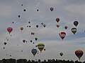
Montgolfiade
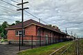
Canadian Pacific Railway station
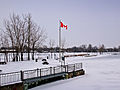
The river port in winter


Personalities
sons and daughters of the town
- Félix-Gabriel Marchand (1832–1900), politician
- Louis Monast (1863–1936), American politician
- Alfred La Liberté (1882–1952), composer and pianist
- Fernand Dorais (1928–2003), novelist and author
- Gilles Villeneuve (1950–1982), Formula 1 racing driver
- Claude Larose (born 1955), ice hockey player
- JF Quintin (* 1969), ice hockey goalkeeper
- Jacques Villeneuve (* 1971), Formula 1 racing driver
- Patrice Désilets (* 1974), computer game designer
- Jeff Drouin-Deslauriers (* 1984), ice hockey goalkeeper
- Kevin Steen (born 1984), wrestler
Personalities related to the city
- Honoré Mercier (1840-1894), politician
Web links
Individual evidence
- ↑ a b c Saint-Jean-sur-Richelieu. Commission du toponymie du Québec, accessed January 8, 2014 (French).
- ↑ Le régime français. Musée du Fort Saint-Jean, accessed January 8, 2014 (French).
- ↑ Ère britannique coloniale. Musée du Fort Saint-Jean, accessed January 8, 2014 (French).
- ^ Culture. City of Saint-Jean-sur-Richelieu, 2011, accessed January 8, 2014 (French).
- ↑ Population profile of the commune of Saint-Jean-sur-Richelieu. In: 2011 Census. Statistics Canada , 2011, accessed January 8, 2014 (French).
- ↑ Population profile of the commune of Saint-Jean-sur-Richelieu. In: 2001 Census. Statistics Canada , 2001, accessed January 8, 2014 (French).
- ↑ Portrait socioéconomique. City of Saint-Jean-sur-Richelieu, 2011, accessed January 8, 2014 (French).
- ^ Carrefour Richelieu. (No longer available online.) Westcliff Group of Companies, archived from the original on January 8, 2014 ; Retrieved January 8, 2014 (French). Info: The archive link was inserted automatically and has not yet been checked. Please check the original and archive link according to the instructions and then remove this notice.
- ↑ Ruralité et agriculture. City of Saint-Jean-sur-Richelieu, 2011, accessed January 8, 2014 (French).
- ↑ Ville militaire, ville garrison. City of Saint-Jean-sur-Richelieu, 2011, accessed January 8, 2014 (French).