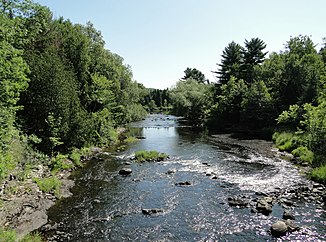
Rivière du Loup (Lac Saint-Pierre)
| Rivière du Loup | ||
|
Rivière du Loup near Saint-Paulin |
||
| Data | ||
| location | Mauricie in Quebec (Canada) | |
| River system | Saint Lawrence River | |
| Drain over | Saint Lawrence River → Atlantic Ocean | |
| origin |
Lac de la Crécerelle 46 ° 50 ′ 1 ″ N , 73 ° 24 ′ 41 ″ W. |
|
| muzzle |
Lac Saint-Pierre Coordinates: 46 ° 13 '10 " N , 72 ° 55' 25" W 46 ° 13 '10 " N , 72 ° 55' 25" W. |
|
| Height difference | 457 m | |
| Bottom slope | 3.6 ‰ | |
| length | 126 km | |
| Catchment area | 1528 km² | |
| Discharge at the Louiseville A Eo gauge : 1430 km² |
MQ 1965/1970 Mq 1965/1970 |
23.8 m³ / s 16.6 l / (s km²) |
| Drain |
MQ |
27 m³ / s |
| Left tributaries | Ruisseau des Pins Rouges, Rivière à l'Eau Claire | |
| Right tributaries | Rivière des Îles, Rivière Sacacomie, Rivière aux Écorces , Rivière Saint-Louis, Rivière Chacoura, Petite rivière du Loup | |
| Flowing lakes | Lac Bourassa | |
| Small towns | Louiseville | |
| Communities | Saint-Alexis-des-Monts | |
The Rivière du Loup (literally translated: "Wolf River") is a left tributary of the Saint Lawrence River in the Mauricie administrative region of the Canadian province of Québec .
The Rivière du Loup has its origins in the in faunique Réserve Mastigouche nearby Lac de la crécerelle . It flows through the Laurentine Mountains in a predominantly southern direction. Shortly before its confluence with Lac Saint-Pierre , a river widening of the Saint Lawrence River, it flows through the small town of Louiseville . The 126 km long river lies within the regional county town of Maskinongé . On the upper reaches is the Barrage du Lac-Bourassa , which regulates the outflow of the Rivière du Loup. The catchment area covers 1528 km². The mean discharge is 27 m³ / s.
The river name is derived from the seals ( French loups-marins ) at the mouth of the Rivière du Loup.
Hydropower plants
At the Rivière du Loup is 3.5 km east of Saint-Paulin below the Route 350 the Laufwasserkraftwerk Saint-Paulin ( ⊙ ). It was put into operation on November 29, 1994. It has an 8 MW Francis twin turbine . The hydraulic potential is 44 m. The annual output is 41,072 MWh.
Web links
Individual evidence
- ↑ a b c Bureau Brille publiques sur l'environnement (PDF; 103 kB)
- ↑ Water Survey of Canada: Station 02OC005 ( page no longer available , search in web archives ) Info: The link was automatically marked as defective. Please check the link according to the instructions and then remove this notice.
- ^ Commission de toponymie du Québec: Rivière du Loup
- ↑ a b innergex.com
