Rock port
| Rock port | |
|---|---|
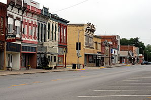
 Center of Rock Port |
|
| Location in Missouri | |
| Basic data | |
| State : | United States |
| State : | Missouri |
| County : | Atchison County |
| Coordinates : | 40 ° 25 ′ N , 95 ° 31 ′ W |
| Time zone : | Central ( UTC − 6 / −5 ) |
| Residents : | 1,318 (as of 2010) |
| Population density : | 178.1 inhabitants per km 2 |
| Area : | 7.4 km 2 (approx. 3 mi 2 ) of which 7.4 km 2 (approx. 3 mi 2 ) is land |
| Height : | 287 m |
| Postal code : | 64482 |
| Area code : | +1 660 |
| FIPS : | 29-62696 |
| GNIS ID : | 730197 |
| Website : | rpmo.com |
| Mayor : | Jeffrey Seaman |
Rockport is a town and administrative center of the Atchison County in the northwest of the US -amerikanischen state of Missouri . At the 2010 census , Kirksville had 1,318 residents.
geography
Rock Port lies at 40 ° 24'44 "north latitude and 95 ° 31'11" west longitude and extends over 7.4 km², which consists exclusively of land. Rock Port is located in the extreme northwest of Missouri a few miles east of the Missouri River , which forms the border with Nebraska . The Iowa border is 12 miles north of Rock Port.
Neighboring towns are Watson (15.7 km northeast), Tarkio (14.6 km east-northeast), Fairfax (17.1 km southeast), Langdon (9.9 km southwest) and Brownville on the western bank of the Missouri in Nebraska (14th district) , 0 km west).
The closest major cities are Omaha in Nebraska (122 km north-northwest), Iowa's capital Des Moines (283 km northeast), Kansas City (185 km southeast) and Nebraska's capital Lincoln (135 km northwest).
traffic
On the western outskirts of the city, Interstate 29 runs in a northwest-southeast direction , which forms the shortest connection between Omaha and Kansas City on this section. As a west-east bypass road, US Highway 136 runs along the northern edge of Rock Port. 13 km west of the city, the Brownville Bridge , crossing the Missouri, is the shortest connection to Nebraska. Missouri State Route 11 runs through the city center in a north-south direction .
Individual evidence
- ↑ US Census Bureau. Retrieved February 1, 2012
- ↑ Google Maps. Retrieved February 1, 2012
