Rodman Cove
| Rodman Cove | ||
|---|---|---|
|
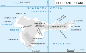
Map of Elephant Island with Rodman Cove (left) |
||
| Waters | Drake Street , Southern Ocean | |
| Land mass | Elephant Island , South Shetland Islands | |
| Geographical location | 61 ° 7 ′ 4 ″ S , 55 ° 27 ′ 28 ″ W | |
|
|
||
The Rodman Cove (in the UK Emma Cove is) a bay on the west coast of Elephant Iceland in the archipelago of the South Shetland Islands . It is located south of Cape Lindsey .
The American geographer Lawrence Martin named it before 1943. It is named after the American whaling entrepreneur Benjamin Rodman from New Bedford , whose fleet operated from this bay in the 1820s and 1830s. Scientists from the British Joint Services Expedition (1970–1971) named it after the schooner Emma , with which the British polar explorer Ernest Shackleton made an unsuccessful attempt in mid-July 1916 as part of the Endurance Expedition (1914–1917) from Punta Arenas , to rescue the expedition members stranded on Elephant Island.
Web links
- Rodman Cove in the Geographic Names Information System of the United States Geological Survey (English)
- Rodman Cove on geographic.org (English)

