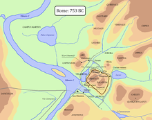
Roma quadrata
As quadrata Roma the (legendary) first settlement core of Rome called. The term is often used in research to denote an archaeologically only imprecisely verifiable, mostly in the 10th / 9th centuries. Century BC Early settlement on the summit of the Germalo, one of the three elevations of the Palatine , to name.
The original shape of the terrain can be determined by analogy and geological findings from this and other parts of the Tiber Valley . The landscape was characterized by relatively high hills, some of which could be very steep and characterized by rugged flanks and a generally flat knoll. These flattened peaks offered good opportunities for the establishment of settlements, which, for security reasons, were built as settlement centers on such hills rather than in the valleys below. The peculiarity of the palatine dome was its trapezoidal shape, which possibly gave this first Rome the nickname " quadrata ".
To defend these first urban settlements, the natural shape of the landscape was used as far as possible, so that walls or fortifications were only built where the slope of the hill was not steep enough to prevent undesired access to the summit. Often a trench was also dug on the outside of the wall in order to further reduce the vulnerability on the naturally unprotected sides.
According to the legend, the trench allegedly dug by Romulus presumably had the function of the pomerium , i.e. a sacral border. Another explanation of the name quadrata , attested much later, is offered by Sextus Pompeius Festus and Properz , according to which it could refer to the moon, i.e. the trench that was dug in the exact center of the pomerium and filled with all cult and oracle objects that the Priests had used at the inauguration ceremony of the new city.
However, so far none of this has been archaeologically proven, so much remains speculation. The protective wall between Germalo and Palatine is little more than an assumption on the basis of a depression between the two elevations that appears a little too strong. In view of the ancient shape of the hill, it is very likely that a first wall and the ditch accompanying it were only built - if at all - on the side between Germalo and Palatine, to defend the weakest side, even if the Pomerium in its meaning as sacred City limits certainly encompassed the entire inhabited area.
The legendary Roma quadrata , mentioned by some of the later authors - Dionysius of Halicarnassus , Plutarch , Cassius Dio , Festus and Solinus - is said to have included both surveys with the exception of the Velia . It is controversial whether these reports, which were created centuries later, have a historical core and what this may consist of. Cassius Dio apparently found only vague information about the Roma quadrata in his own sources . It is noteworthy, however, that he writes that it was a settlement that had nothing to do with what would later become Rome: rather, the Roma quadrata was founded long before by a couple who happened to be called Romulus and Remus. This may indicate that in addition to the tradition of the founding of Rome, which later became canonical, there were also other legends. Tacitus , however, provides some evidence of the first enclosure of the city, those using the following hypothetical course of 1.5 km gives: from the Basilica of Sant'Anastasia along the south side of the Palatine to the church of San Gregorio Magno , head toward Arch of Constantine , continue to the Arch of Titus and the Basilica of Santa Francesca Romana , and then, following the course of today's Via di S. Teodoro, through the Velabrum to the starting point, the church of Sant'Anastasia al Palatino. It is obvious that some parts of this course benefited from the natural conditions and therefore did not need a wall.
Whether the alleged wall enclosed the city completely or only partially: it must have had gates in any case. Even the aforementioned authors of the imperial era, who wrote six to eight centuries apart, could not give any precise information about the number or the names of these gates. Pliny , normally very precise in such matters, may serve as an example , according to which there were “three or perhaps four” gates in a section of wall between the Palatine and the Capitol . This “historical” note already contains another inaccuracy, since the inclusion of the Capitol in the urban area did not occur until a few centuries after the origin of the original Roma quadrata. The most widespread hypotheses, following Varro's advice, assume the existence of a Porta Mugionia , which could have been near the Arch of Titus, a Porta Romana or Romanula near the Velabrum, and a third gate (perhaps Ianuaria , Ianualis , Trigonia ), whose location is completely unclear.
In the following years and up to the erection of the Servian Wall in 378 BC. The urban structure that developed in BC was organized in a decentralized manner. The individual elevations that made up the city did not form a defensive unit, but each had independent military structures that were more dependent on the people than on fortifications. Only the capture of Rome by the Gauls v in 390th Chr. Questioned this system and showed the need for a uniform fortification. Up to this point in time, the orographic layout of the hills, possibly supported by walls or ditches, had apparently offered sufficient protection and defense.
literature
- Samuel Ball Platner , Thomas Ashby : A Topographical Dictionary of Ancient Rome . Oxford University Press, London 1929, pp. 374-377 ( online ).
- Laura G. Cozzi: Le porte di Roma . F. Spinosi Ed., Roma, 1968.
- Mauro Quercioli: Le mura e le porte di Roma . Newton Compton, Roma, 1982.
