
Ropotamo
| Ropotamo | ||
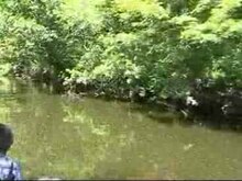
 The Ropotamo in the nature reserve near the mouth |
||
| Data | ||
| location | Burgas Oblast , Bulgaria | |
| River system | Ropotamo | |
| source | in the Strandscha Mountains 42 ° 11 ′ 19 ″ N , 27 ° 27 ′ 11 ″ E |
|
| muzzle | between Sozopol and Primorsko into the Black Sea Coordinates: 42 ° 19 ′ 41 ″ N , 27 ° 45 ′ 19 ″ E 42 ° 19 ′ 41 ″ N , 27 ° 45 ′ 19 ″ E
|
|
The Ropotamo is a river in Bulgaria .
In the southeast of Burgas , between Sozopol and Primorsko , on an area of about 100 km², lies the mouth of the Ropotamo River, a still young nature reserve . It used to be the hunting ground of the communist elites and has long been inaccessible.
The area includes swamps, islands, cliffs, sandy beaches, bays, forests and pastures, and is particularly known for its abundance of flora and fauna. More than 500 different plant species grow here and there are many turtles , pelicans , kingfishers, storks, cormorants , deer, reptiles and some wild boars and jackals .
Since 2004, the river has given its name to the Ropotamo Glacier on Livingston Island in Antarctica.
Ropotamo Conservation Complex
The Ropotamo nature conservation complex is located approx. 10 km south of Sozopol. It includes the Ropotamo Biosphere Reserve , which was declared at the mouth of the river of the same name; the island of Sveti Toma ; the nature reserves Alepu , Stomoplo and Arkutino , as well as the southern end of the Gulf of Burgas with the Cape Maslen nos .
Individual evidence
- ^ Official website of the Sozopol Municipality: General information about the Sozopol Municipality. Retrieved June 6, 2012 (Bulgarian).