Burgas Oblast
| Basic data | |
|---|---|
| Region: | Southeast Bulgaria |
| Administrative headquarters: | Burgas |
| Address: | ul. "Tzar Peter" No. 1 |
| 8000 Burgas | |
| Surface: | 7,753.14 km² |
| Residents: | 411,579 (Dec. 31, 2017) |
| Population density: | 53.1 inhabitants per km² |
| NUTS: BG code: | BG341 |
| Average annual temperature: | 13 ° С |
| Oblast administrator: | Konstantin Grabenarow |
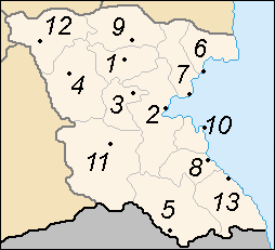
| map | |
The Burgas Oblast ( Bulgarian Област Бургас ) is an administrative district in southeastern Bulgaria and the largest in Bulgaria by area. The administrative seat is the city of the same name, Burgas .
The Burgas Oblast is of supranational geostrategic importance. Here traditional and new axes of economic and political interests intersect: Europe-Middle East-Asia; Europe-Middle East-Asia; Russia, Ukraine, Western and Southwestern Europe-Eastern Europe-Caucasus.
Economy and industry
Burgas Oblast is the main import / export center of Bulgaria. The reasons for this are extensive natural resources of national importance (above all coal and minerals), fertile soils for agriculture, the existence of highly qualified workers in all economic sectors, as well as a high social standard and a balanced market infrastructure. The oblast is also home to the largest tourist and recreation centers in Bulgaria on the Black Sea. Nature, mountain and ecotourism, various thermal springs as well as numerous historical sights and excavation sites expand the tourist offer.
The economy The Burgas Oblast generates 5.22% of the national GDP.
- Burgas Airport with Cargo Terminal and Primorsko Airport
- Burgas Free Trade Zone
- Large and well-developed train stations in Burgas , Karnobat and Aytos ;
- Large transport companies in Burgas and Karnobat ;
- Port complex of Burgas- Port Bourgas , oil and fishing ports; other ports in Sozopol , Nessebar , Tsarevo and Ahtopol , marinas in Burgas, Sozopol, Djuni and Sweti Vlas ,
- Extensive storage areas - close to the port , Burgas airport , industrial train station and the Burgas - Sofia and Burgas - Varna highways
Industry is the main economic activity in the region. It is diverse. The following industries are leading in the region:
- Oil processing, oil processing and chemical industries - 70% of the total economic output;
- Food industry and viticulture - 12.2%;
- Steel industry and energy - 3.6%;
- Textile industry - 2.4%.
Burgas Oblast is highly industrialized. Tourism, agriculture, wood processing industry, light industry, shipbuilding and the very good infrastructure are among the economic factors in the region.
At 7.2 percent (as of June 2012), unemployment is the second lowest in the country after Sofia City Oblast .
Administrative division
The Burgas Oblast is divided into 13 municipalities (община) , which in turn consist of 18 cities and numerous villages.
cities and communes

|
nature
Waters
Protected areas
Several nature reserves border the urban area of Burgas or are part of the city. The nature reserves Atanasov and Mandra Lakes, which have existed since 1980, now have an area of 1,002.3 hectares after several expansions. In 1997, a large part of the Burgas lake and its shores were declared a nature reserve with an area of 379 hectares. Other nature reserves are: since 1990 the area of the mouth of the river Isworska , with an area of 150 ha, since 1989 the nature reserve Poda , with an area of 100.7 ha, since 1995 the area of Tschengene Skele , with an area of 191.19 ha , the Korijata nature reserve with an area of 11.6 hectares, established in 1995 and the Bay of Mandra Lake Usungeren, which was declared a nature reserve in 2005 . The natural attraction Wodenizite , which has a protected area of 73.6 hectares, has also been a protected area since 1995 . The largest Bulgarian nature park, the Strandscha Nature Park, extends south of the city .
Web links
- Official website of the Oblast (English, Bulgarian)
- Official website of the Apolonia International Culture Days (English, Bulgarian)
- Archeology and archaeological sites in Burgas Oblast (English, Bulgarian)
- Official website of Burgas City Opera (English, Bulgarian)
- Official website of the museums in the Oblast (English, Bulgarian)
- Municipality of Burgas City (English, Bulgarian)
Individual evidence
- ↑ a b Burgas (Bulgaria): Municipalities & Places - Population Statistics, Graphics and Map. Retrieved June 12, 2018 .
- ↑ The unemployment rate continues to fall
- ↑ Atanasovsko Lake. Important bird areas. Specialized website on bird protection in Bulgaria: Birdsinbulgaria.org, accessed on December 20, 2011 (English).
- ↑ a b c d Specialized website for bird protection in Bulgaria: Birdsinbulgaria.org: Mandra-Poda-Usungeren-Complex. Important bird areas. Retrieved December 20, 2011 .
- ↑ Burgas Lake. Important bird areas. Specialized website on bird protection in Bulgaria: Birdsinbulgaria.org, accessed on December 20, 2011 (English).
- ↑ Chengene Skele. Important bird areas. Specialized website on bird protection in Bulgaria: Birdsinbulgaria.org, accessed on December 20, 2011 (English).


