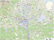
Rosenheim basin
The Rosenheim Basin is the bottom of the former Rosenheimer See , a lake that formed in the tongue basin from the melting Inn glacier at the end of the Würm Ice Age in the area of today's city of Rosenheim . At 420 km², this lake was almost as big as today's Lake Constance and left behind up to 150 m thick sediments . With the silting and United sumpfung the lake Rosenheim were able to mighty Moore grow. Today's Simssee is a remnant of the Rosenheimer See.
The Rosenheim basin is bounded by the mighty marginal and terminal moraines left by the glacier: the Irschenberg in the west in the area of Markt Bruckmühl, the moraine breakthrough between the town of Wasserburg am Inn and the Attel district in the north . In the east, the Inn glacier merged into the Chiemsee glacier, the sediment collected in intermediate moraines between Riedering and Prien . Drumlins can be found northwest (near Tuntenhausen ) and northeast of Rosenheim.
literature
- Ludwig Eid : From Alt-Rosenheim . Verlag des Stadtarchivs, Rosenheim 1906. Chapter Primeval times , p. 8 ff. ( Digitized version ).
Web links
Individual evidence
- ↑ merkur-online.de: The giant lake that has disappeared
- ↑ Federal Agency for Nature Conservation: Landscape profile 3802 alpine upland between Mangfall and Inn ( page no longer available , search in web archives ) Info: The link was automatically marked as defective. Please check the link according to the instructions and then remove this notice.
Coordinates: 47 ° 51 ′ 0 ″ N , 12 ° 8 ′ 0 ″ E
