Rosso (Mauritania)
| Rosso روصو |
||
|---|---|---|
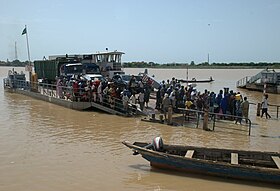
 Arrival of the ferry |
||
| State : |
|
|
| Region : | Trarza | |
| Department: | Rosso | |
| Coordinates : | 16 ° 31 ′ N , 15 ° 48 ′ W | |
| Height : | 6 meters above sea level | |
| Residents : | 48,922 (2002) | |
| Time zone : | GMT ( UTC ± 0 ) | |
|
|
||
Rosso , Arabic روصو, DMG Rūṣū , orالقوارب, DMG al-Quwārib , is the capital of the Trarza administrative region on the lower reaches of the Senegal River in southwest Mauritania . The Rosso ferry on the only continuously paved road that connects Mauritania with its southern neighbor, Senegal , makes Rosso the most important trading city in the interior.
location
South of the 17th parallel, Mauritania has a narrow part of the Sudan zone . In the several kilometers wide flood plain (Chemama) with fertile alluvial soils along the Senegal River, rice is mainly grown, next to which millet and vegetables (corn, beans, sweet potatoes, peanuts) thrive in small fields. After the rainy season, which lasts from June to September, many fields are flooded by rains; during the rest of the year they are irrigated via canals from Senegal. A few kilometers north with characteristic individual is acacia -lined dry savannah of sand dunes replaced.
Rosso is located 203 kilometers south of the state capital Nouakchott and about 100 kilometers from Saint-Louis in Senegal . The landing site of the ferry on the opposite bank of the river is the town of Rosso-Sénégal . The road upstream to the east to Bogué , a good 200 kilometers away , was paved by a Chinese company. Only a 30 km long section near Rosso is still in the condition of the slopes (as of October 2010). To the west, a bad road leads in parts between rice fields to the small town of Keur Massène, 60 kilometers downstream, where there is a border crossing to Diamma.
history
The port is a historic trading center for goods from Senegal. The French colonial rule over West Africa in 1900 extended to the Senegal River as the northern border. The French colonial official Xavier Coppolani came up with the plan for a peaceful penetration of Mauritania. French troops were present in southern Mauritania until 1904.
After Mauritania gained independence in 1960, there were only a dozen small towns in the new state with a population of a few thousand. In 1963 Rosso was estimated to have 5100 inhabitants. In 1988 a census showed 27,783 inhabitants, in 2000 there were 48,922 inhabitants. According to a calculation, the number should have grown to 75,195 inhabitants in 2010. This made Rosso the fourth largest city before Kaédi .
In 1986, a Chinese-built deep-water port was opened in Nouakchott on the Atlantic coast. Before that, the entire south of Mauritania had to be supplied with goods via Senegalese ports and further by land via Rosso. With the new port, 35 to 40 percent of the imports that were previously processed via Dakar can now reach the capital directly and Rosso has lost its importance accordingly.
Rosso is inhabited in the vast majority of black Africans, who in Mauritania are known as Soudans . Many come from Senegal and belong to the Wolof . A racial conflict between the Arab- Berber- dominated government (the Bidhan social class) and a black uprising movement ( Forces de Liberation Africaine de Mauritanie, FLAM) led to the Senegal-Mauritania crisis in April 1989 , which meant the closure of the border for Rosso until 1992 . Senegal offered hospitality to the Mauritanian opposition during this period. 10,000 politically unpopular people from both countries were expelled and exchanged for one another by airplanes. The tensions in the southern region were largely of economic origin and took place between arable farmers and ranchers. Large-scale irrigation projects extended the arable land on the Senegal bank, while cattle ranchers flee from the north during periods of drought near the river. Further tensions with the neighboring country, which affected the city, arose in June 2000.
A technical college opened in 2009 ( Institut Supérieur d 'Enseignement Technologiques, ISET) offers an agricultural training course.
Cityscape
The port facility and customs building are located on the southwestern edge of the city center. Opposite is a large military barracks, behind which rice fields will soon begin along the road to Keur Massene. The paved road to Nouakchott leads from the harbor past some industrial plants straight north. On the outskirts of the village, the SONIMEX facility, the semi-state trading company for agricultural products, cannot be overlooked. The first three parallel streets to the east of Senegal, together with cross connections, form the rectangular network of streets in the market center. To the east of the center there is another large military area ( Kommandantur ), before a simple residential and slum area extends about one kilometer to the east and one kilometer to the north from the river, where the black African population who recently moved to the city has come to live.
The oldest and possibly largest preserved church in the country is in Rosso. The Roman Catholic pastor Bernard Pelletier (as of May 2010) looks after the handful of French people living in the city.
At the beginning of the 1980s, the ecologically oriented group of architects Association pour le Développement d'une Architecture et d'un Urbanisme Africains (ADAUA) built a housing estate planned for 12,000 residents in Satara, a slum area north of the business center that is regularly affected by annual flooding are covered with the domed roofs made of fired bricks typical for the organization. Construction time and costs were higher than for the usual informally built brick houses with corrugated iron roofs. Similar designs were realized at the Hôpital de Kaédi and in housing estates in other cities in Mauritania.
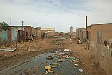
No road in the city is paved. There is no sewer system except for a few short sections of concrete gutters at the roadside, which are not yet functionally connected to one another. Rosso is located in the rainiest area of Mauritania. Practically every year at the end of the rainy season in September floods due to heavy rains are reported. Large parts of the residential areas and the main streets of the city are then flooded and muddy for months and many residents, usually thousands, have to flee to temporary accommodation outside of the city.
Another problem is the lack of garbage disposal, which leads to garbage deposits over large parts of the city. Dealing with animal waste is carefree. A once modern slaughterhouse from French times is neglected, while cattle is slaughtered every morning at a different place outdoors. Apart from the barracks buildings, the structure and infrastructure are neglected. In simple residential areas, drinking water is usually supplied with donkey carts from central distribution points.
Sports
The ASC Gueumeul football club is based in Rosso.
Web links
Individual evidence
- ^ Walter Reichhold: Islamic Republic of Mauritania. Kurt Schröder, Bonn 1964, p. 18
- ↑ Anthony G. Pazzanita: Historical Dictionary of Mauritania. The Scarecrow Press, Lanham (Maryland), Toronto, Plymouth, 3rd ed. 2008, p. 440
- ^ Mauritania: Les villes les plus grandes avec des statistics de la population. World Gazetteer
- ^ Nouakchott's Friendship Port built by China. In: Mauritania - A Country Study. US Country Studies, June 1988
- ↑ Case N ° 1: Senegal-Mauritania-conflict: Drought cycle and evolution of pastoralist dynamics. (PDF; 496 kB) OECD
- ↑ Regina Wegemund: The foreign policy of Mauritania with special attention to relations with Senegal. In: Ursel Clausen (Ed.): Mauritania. An introduction. German Orient Institute, Hamburg 1994, pp. 97f
- ^ Institut Supérieur d 'Enseignement Technologiques de Rosso. (ISET)
- ↑ Rosso, Mauritanie: un prêtre sans paroissiens. blog.lefigaro, May 14, 2010
- ↑ Satara Zone Housing. ( Memento of the original from June 19, 2010 in the Internet Archive ) Info: The archive link was inserted automatically and has not yet been checked. Please check the original and archive link according to the instructions and then remove this notice. Association pour le Développement d'une Architecture et d'un Urbanisme Africains (ADAUA), 1983, pp. 151-154. As a PDF at ArchNet
- ^ ACT Alert: Floods in Mauritania. AlertNet, September 28, 2009


