Kaedi
| Kaedi كيهيدي |
||
|---|---|---|
 Business center and great mosque |
||
| State : |
|
|
| Region : | Gorgol | |
| Department: | Kaedi | |
| Coordinates : | 16 ° 9 ′ N , 13 ° 30 ′ W | |
| Height : | 23 meters above sea level | |
| Residents : | 55,000 | |
| Time zone : | GMT ( UTC ± 0 ) | |
|
|
||
Kaédi ( Arabic كيهيدي, DMG Kaihaidī ) is the capital of the administrative region Gorgol on the Senegal River in southern Mauritania . The place has a certain economic importance as a river port and lies on a fertile plain with irrigated fields. The Kaédi Regional Hospital is known for its innovative architectural concept.
location
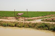
Kaédi lies in the area of the dry savannah , which includes a strip south of the 17th parallel in the desert country of Mauritania, within the flood plain (Chemama) , which is a few kilometers wide, along the Senegal River. In the surrounding area, rice and millet thrive on large parceled areas . The fields are irrigated via canals that are supplied with diesel pumps from the Senegal River or derived from the Gorgol. This tributary of Senegal is held back by a dam at its confluence on the eastern edge of the city. At the end of the summer rainy season, it can expand into a lake that extends far to the north.
The state capital Nouakchott is 435 kilometers to the northwest. In the same direction, the paved road runs along Senegal to the small town of Bogué , 105 kilometers away , the only other asphalt road ends 230 kilometers southeast in Sélibaby . The river port is used to exchange goods with Senegal . There is no border crossing for foreigners.
Kaédi has a 2.5 km long unmarked runway at the northern end of the village. There are no regular flights to the civil airport ( IATA airport code : KED).
North and west of Kaédi, in a triangle to the cities of Bogué and Aleg , near-surface phosphate deposits were found, which were reported in 1989. The horizontal layers around two meters thick at Boufal and Loubboira have sufficient phosphate content for mining. In January 2008, China Exim Bank announced its willingness to finance part of the costs for a planned railway line for the transport of phosphate between Nouakchott and Kaédi.
history
Kaédi was one of the centers of Islamic learning in the Middle Ages. Centuries-old Arabic manuscripts have been preserved in a library. The colonial era began around 1890 with the advance of French units into the interior. The Tukulor leader Abdoul Boubakar ruled from his Kaédi post over the Bossea area, which lay in the Fouta Toro region stretching on both sides of the central Senegal River . Because Abdoul Boubakar gave refuge to the ruler of the Wolof Empire Jolof , Alboury Ndiaye, and his anti-French fighters, the French shelled the place on July 20, 1890. Boubakar's amalgamation with the Bidhan of the Brakna region failed, as did Ndiaye's attempt to recruit further troops in Kaédi for the liberation of his region of origin, and by 1891 the French had conquered the entire valley of the Senegal River.
In mid-1929 there was a religious uprising in Kaédi, which was sparked by Yacouba Sylla . The Sufi -Prediger had the Order of Tidschani split off and took advantage of the tensions between the French government and local tribal elite in Kaédi to the Soninke -Minderheit own, Yaqubiyya almost bring-called interpretation of radical Islamic ideas for reform of the Hamallaya- (Hamalliyya-) Order. His ideas were unacceptable to the majority of Muslims. Although the French deported Sylla to Ivory Coast in December 1929 , the unrest of his supporters lasted until the end of the following year.
Shortly after independence was declared in 1960, the then existing cities of Mauritania all had population figures in the four-digit range. For Kaédi, the number of residents was estimated at 8,000 in 1963. In 1970 there were around 20,000, the 1988 census showed 30,515 inhabitants, in 2000 the census showed 34,227 inhabitants. According to a calculation, the number should have grown to 55,374 inhabitants in 2010.
Kaédi became significant for the country's history in 1964 when the Kaédi Conference took place on January 28th and 29th , which became a key event for the country's political development. The first president, Moktar Ould Daddah , announced to the assembled members of his unity party Parti du Peuple Mauritanien (PPM) the new authoritarian course, with which the party was practically degraded to the executive organ of presidential politics until its dissolution in 1978.
In the 1960s, the government set up large farms of up to 500 hectares around Kaédi on the socialist model. In 1968 a veterinary training facility was opened. The place owed its economic growth in the following period mainly to trade with Senegal.
In October 1987, an attempted coup by three black African officers against the government of President Maaouya Ould Sid'Ahmed Taya was uncovered, suggesting Senegal's interference in political tensions in the country between the Bidhans (whites, often equated with Arab ancestry) and Soudans (collectively for Black Africans) suspected. After the officers were executed on December 6, 1987, civil war riots broke out in the south. Kaédi is mostly inhabited by Halpulaaren ( Tukulor and Fulbe ), to which the putschists also belonged. As a result, protests by the black African opposition group Forces de Liberation Africaine de Mauritanie (FLAM) against the government dominated by Bidhans broke out in the city . The racial conflict led to the Senegal-Mauritania crisis in April 1989 , which temporarily led to the border being closed. For Kaédi and the surrounding area, laws comparable to martial law were enacted; Trade and free movement were no longer possible. The tension did not ease until 1991.
Cityscape
Most of the city's population comes from Senegal. Most of the inhabitants are Halpulaaren, a minority Soninke and a few are Bidhan from the north. The market center is a few hundred meters north of the Senegal River. Few of the tiled roofs on houses from the colonial era are striking. The busy market differs from the Arabic-influenced trading centers further north in the range of colorful fabrics from Senegal. In the eastern part is the central square where the collective taxis (taxi brousse) going to Bogué wait. On the river bank to the east, residential areas spread out with houses made of adobe bricks , which, as is customary in the Sudan zone , are grouped behind a surrounding wall around an inner courtyard. At a greater distance from the river there are residential areas with partly dilapidated houses. The loamy Senegal bank serves as a washing and bathing area.
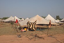
The main road runs from the river about 1.5 kilometers in a north-westerly direction to the hospital, where the arterial road in a south-westerly direction to Bogué begins. If you continue straight ahead, the road ends after almost a kilometer at the runway that borders the city in the north. Beyond begins the open savannah with individual acacias (such as Acacia seyal ). Separated from the city, impoverished Bidhan nomads pitch their simple white tents (khaima) here . The camp is reminiscent of refugee camps. In southern Mauritania, gatherings of 50 to 100 tents are traditionally common, while in the northern desert there are no more than a dozen tents.
Sports
The ADK Moderne Kaédi football club is based in the city.
Individual evidence
- ↑ Kaedi. World Aero Data
- ^ China Exim Bank to finance railway project in Mauritania. China Daily, Jan 23, 2008
- ^ Eunice A. Charles: Ouali N'Dao: The Exile of Alboury N'Diaye. In: African Historical Studies , Vol. 4, No. 2, 1971, pp. 373-382, here p. 376
- ↑ Sean Hanretta (Ed.): Islam and Social Change in French West Africa. History of an Emancipatory Community. Cambridge University Press, Cambridge 2009. Excerpt ; Jamil M. Abun-Nasr: The Tijaniyya. A Sufi Order in the Modern World. Oxford University Press, London / New York / Toronto 1965, pp. 155f
- ^ Walter Reichhold: Islamic Republic of Mauritania. Kurt Schröder, Bonn 1964, p. 18
- ↑ Anthony G. Pazzanita: Historical Dictionary of Mauritania. The Scarecrow Press, Lanham (Maryland), Toronto, Plymouth, 3rd ed. 2008, p. 283
- ^ Mauritania: Les villes les plus grandes avec des statistics de la population. World Gazetteer
- ↑ Regina Wegemund: The foreign policy of Mauritania with special attention to relations with Senegal. In: Ursel Clausen (Ed.): Mauritania. An introduction. German Orient Institute, Hamburg 1994, p. 91f


