Aleg
| Aleg ألاك |
||
|---|---|---|

|
||
| State : |
|
|
| Region : | Brakna | |
| Department: | Aleg | |
| Founded : | 1970s | |
| Coordinates : | 17 ° 3 ′ N , 13 ° 55 ′ W | |
| Height : | 36 meters above sea level | |
| Residents : | 25,915 | |
| Time zone : | GMT ( UTC ± 0 ) | |
|
|
||
Aleg ( Arabic ألاك, DMG Alāk ) is the capital of the administrative region Brakna in southwest Mauritania . The small town, created by rural exodus since the 1970s, is a stopover on the route de l'Espoir , the only paved road that crosses the country from west to east.
location
Aleg is located 262 kilometers southeast of the state capital Nouakchott on the southern edge of the Mauritanian Sahara and at the transition to the dry savannah . The 1100 kilometer long road from the Atlantic coast to Néma , the last town before the Mali border, leads in an arc right through the town. Five kilometers west of the center, the 70-kilometer road branches off south to Bogué on the Senegal River .
The Oued Katchi stretches from southeast to northwest , a wide, flat dry valley at 100 meters above sea level, which is bordered on the lateral edges by isolated rocky ridges. The embankment of the adjoining plain protrudes around 40 meters above the valley. Aleg benefits in the middle of this basin from the groundwater resources that accumulate in a catchment area of 170 kilometers in length. A few kilometers to the northwest, the Oued ends in Lac d'Aleg, a year-round water-bearing freshwater lake. Broad bands of transverse, solid and hardly elevated sand areas border the lake in the north and cut through the oued south of the city. The Oued Katchi used to be a tributary of Senegal, from which it is now separated by two sand barriers.
Lac d'Aleg
The annual precipitation in Aleg averaged 203 millimeters between 1961 and 1990, an average value for the dry Sahel zone . Since the turn of the millennium, the precipitation, mostly as thunderstorms, has increased from June to October. In January, the lake has a surface of around 2500 hectares at a water depth of one to two meters; at the end of the rainy season, at a maximum depth of three to four meters, it forms a flood surface of up to 5000 hectares, which can extend to the edge of the village. Where the water withdraws, the drying edges with vegetation are used as pastures for cattle and for agriculture. The natural vegetation around the lake in its immediate surroundings is characterized by water spinach , Tiger Lotus , Echinochloa stagnina (a sort of barnyard grass ), further away Sesbania and Cynodon dactylon . The desert date and Capparis decidua (family of the capers ) are the smaller trees .
The lake may play a more important role as a habitat for migratory birds than the Senegal River Delta with Diawling National Park . The larger wetlands there have been artificially altered by dams and canals for field cultivation, while the birds seem to prefer the natural environment of Lac d'Aleg. In January 1996, there were 75,000 water birds, including brown glossy ibis , black-tailed godwits , teals , spur geese and swamphen . In January 2001 there were 46 species, the total number of birds was just under 65,000. Since then, the Lac d'Aleg has also been in danger as a bird nesting area and threatens to pollute its surroundings through agriculture.
history
The Lac d'Aleg is an old storage area for trade caravans en route to Sudan . Until around 1900 the French colonial area extended from West Africa on its northern border to the Senegal River. After signing a peace treaty with the Sheikh of Boutilimit in 1902, the initially peaceful penetration of South Mauritania began in the following years. Aleg was founded by French troops in 1903/04 as a small military station with a few permanent houses. During the first half of the 20th century the village remained small as the Mauritanian population lived mostly as nomads in tents until 1960.
In May 1958, a congress was held in Aleg with the aim of settling the differences between the various tribal leaders and uniting all of the country's political groups. The Union Progressiste Mauritanienne (UPM) party, led by future President Moktar Ould Daddah , was intended to become a reservoir for other parties to form national unity during the independence process. The new collecting party formed in Aleg was called Parti du Regroupement Mauritanien (PRM). Its general secretary Moktar Ould Daddah led the country to independence in November 1960.
In the 1970s, a drought of several years and an economic crisis linked to the Western Sahara conflict led to the impoverishment of the population, who fled the desert and settled on the edge of the settlements. The population of Aleg began to grow steadily, the uncontrolled urban expansion without adequate infrastructure measures is a common problem in Mauritania.
In 2000 the census showed 12,898 inhabitants. According to a calculation, the number should have grown to 25,915 inhabitants in 2010.
Cityscape

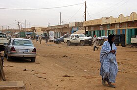
The development from a street village can be seen in the approximately one kilometer long place. The buildings are somewhat denser along the main street, otherwise the residential buildings are located at a greater distance from one another within walled courtyards that are arranged in a rectangular grid. The one-story, flat-roofed houses are mostly made of simple hollow cement blocks. The latest city expansion takes place to the north and east, here the road network is becoming more irregular.
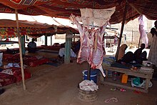
The economic bases are cattle breeding (goats and cattle) and some irrigated agriculture in the area. On the damp lakeshore, which emerges when the water level drops, mainly sorghum is planted on an area of 2250 hectares . The city itself has a certain function as a trading center. On the market, the usual range of imported household goods has almost displaced the handicraft trade. There are some craft shops; The numerous cookshops, in which grilled meat is offered, are used by transit traffic for lunch.
In the early 1970s, an elevated water tank was built for the central supply of drinking water. Its capacity is too low after the city has been enlarged; in many parts of the city the houses have no water connection. Older houses made of mud walls do not withstand the undercutting during heavy rainfall and the flooding of the lake. While the settlement of nomads was mainly a result of the drought, the increased rainfall has been a problem for the settled population since the turn of the millennium.
sons and daughters of the town
- Sidi Mohamed Ould Cheikh Abdallahi , Mauritanian President from 2007 to 2008
Web links
Individual evidence
- ↑ a b Important Bird Areas factsheet: MR 013 - Lac d'Aleg. BirdLife International, 2010
- ↑ Samir I. Ghabbour: Identification of Potential Natural Heritage Sites in Arab Countries. Report to the World Heritage Center UNESCO. Cairo, September 1997, p. 14.
- ↑ Tim Dodman, Cheiks Hamallah Diagana: African Waterbird Census. ( Memento of July 4, 2010 in the Internet Archive ) Wetlands International, Global Series 16, Wageningen (Netherlands) 2003, p. 52.
- ↑ Anthony G. Pazzanita: Historical Dictionary of Mauritania. 2nd Edition. The Scarecrow Press, Lanham (Maryland) / Toronto / Plymouth 2008, p. 55.
- ↑ Statistiques Démographiques: Résultats du RGPH 2000 des Wilayas. ( Memento of January 19, 2014 in the Internet Archive ) République Islamique de Mauritanie
- ^ Mauritania: Les villes les plus grandes avec des statistics de la population. World Gazetteer
- ↑ Jérôme Lejot, Yann Callot: L'homme et l'eau à Aleg (Mauritania): de la pénurie à l'excès. Secheresse 16 (3), 2005, pp. 175-181.

