
Red cliff
|
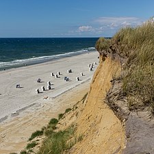
Dune landscape on the Rote Kliff / Sylt
|
||
 Red Cliff (2007) |
||
| location | Wenningstedt and Kampen on the island of Sylt | |
| surface | 167 ha | |
| WDPA ID | 81561 | |
| Geographical location | 54 ° 57 ' N , 8 ° 19' E | |
|
||
| Setup date | 05.03.1979 | |

The Rote Kliff is an approx. 30 meter high cliff between Wenningstedt and Kampen on the North Sea island of Sylt . It is located on the west side of the island facing the open sea . In the south it begins south of the “Risgap” car park in Wenningstedt and in the north it ends at “ Haus Kliffende ” on the Kampener Westheide. A little to the north is the highest point on the island, the approximately 52.5 m high Uwe dune , which, in contrast to the edge of the cliff formed during the Ice Age, was created from postglacial deposits of dune sand.
Geological history
About 120,000 years ago, glaciers from the Saale glaciation deposited massive debris of unsorted rock, including in the area of today's island of Sylt, which became the four geest cores that now form the main mass of the center of the island. The largest of them, the Westerland Geestkern , which originally extended about ten kilometers further to the west, formed an edge due to the rising sea level of the post-ice age and coastal erosion . The rust-red boulder clay, which gave the cliff its name, got its color from the oxidation of ferrous components.
In the 19th century , geologists still suspected a geological connection between Sylt and Heligoland , the rocks of which are of a similar color, but are considerably older and also have a different history. The rocks erupting from the red cliff such as flint , rhombic porphyry or rapaki granite still allow an exact determination of their origin.
For centuries, this striking steep edge was used by shipping as a distinguishing feature of the island. The red cliff is clearly recognizable on A. Haeyens' nautical chart in 1585.
Coastal and nature protection
The Red Cliff has always been seriously endangered by storm surges and erosion and lost several meters in each case by storm surges in 1862, 1881 and 1928. Most recently, the Anatol hurricane at the end of 1999 caused severe crashes. As part of coastal protection , extensive sand flushing has been carried out on the entire west beach of the island since the late 1970s, providing protection against land loss. However, this meant that most of the cliff in the municipality of Wenningstedt is no longer visible, but is covered by dunes overgrown with beach grass .
In 1979 the area was designated as a nature reserve in the entire area between the development and the western sandy beach, starting from the northern development boundary of Wenningstedt , further towards Kampen . This area above the Rote Kliff covers 177 hectares and is recorded under the CDDA code 81561.
gallery

General view from the beach

Aerial photo of the Red Cliff (2017)
The red cliff at the height of the demolition edge (2014)

Demolitions from the Red Cliff ...

... with the remains of buildings

Dune landscape on the red cliff


Individual evidence
- ↑ Kai Ahrendt, Jörn Thiede : Natural spatial development of Sylt - past and future. In: Achim Daschkeit, Peter Schottes (ed.): Climate impacts for people and the coast using the example of the North Sea island of Sylt. Springer, Berlin, Heidelberg 2002, pp. 69–112, here pp. 70 and 73 f.
- ↑ Tanja Tillmann: Fossil spit hooks underground on the island of Sylt: Why is the simple cliff hook theory no longer appropriate? In this. (Ed.): Current coastal research on the North Sea (= Coastline Reports. Vol. 25). Wilhelmshaven 2015, ISBN 978-3-939206-18-7 , pp. 28–44, here pp. 28 f. (PDF).
- ↑ Kai Ahrendt, Jörn Thiede : Natural spatial development of Sylt - past and future. In: Achim Daschkeit, Peter Schottes (ed.): Climate impacts for people and the coast using the example of the North Sea island of Sylt. Springer, Berlin, Heidelberg 2002, pp. 69–112, here p. 89 .
- ^ Gerhard Hartmuth, Susanne Deising, Immo Fritsche, Volker Linneweber : Global change in the local context. Sylt perspectives on climate change. In: Achim Daschkeit, Peter Schottes (ed.): Climate impacts for people and the coast using the example of the North Sea island of Sylt. Springer, Berlin, Heidelberg 2002, pp. 219–250, here p. 224.
- ↑ www.geodienste.bfn.de: Federal Agency for Nature Conservation: Map of the dune landscape on the Red Cliff. Retrieved February 28, 2014 .