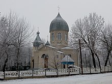
Rudkivtsi (Nowa Uschyzja)
| Rudkiwzi | ||
| Рудківці | ||

|
|
|
| Basic data | ||
|---|---|---|
| Oblast : | Khmelnytskyi Oblast | |
| Rajon : | Nova Ushytsia district | |
| Height : | 253 m | |
| Area : | 1,895 km² | |
| Residents : | 613 (2004) | |
| Population density : | 323 inhabitants per km² | |
| Postcodes : | 32662 | |
| Area code : | +380 3847 | |
| Geographic location : | 48 ° 38 ' N , 27 ° 21' E | |
| KOATUU : | 6823386504 | |
| Administrative structure : | 1 village | |
| Address: | вул. Молодіжна 12 32 660 с. Вільховець |
|
| Statistical information | ||
|
|
||
Rudkivtsi ( Ukrainian Рудківці ; Russian Рудковцы Rudkowzy ) is a village with about 600 inhabitants (2004). in the extreme south-east of the Ukrainian Oblast of Khmelnytskyi .

Dniester reservoir near Rudkiwzi
The village, first mentioned in writing in 1661, belongs administratively to the rural community Nowa Uschyzja ( Новоушицька селищна громада ) founded in 2015 .
Rudkiwzi is located in the south east of the Rayon Nova Ushytsia to the flooded mouth of the 18 km long Matirka ( Матірка ) in the Dnister reservoir accumulated Dnister 28 km south of Nova Ushytsia and about 115 km south of the Oblasthauptstadt Chmelnyzkyj .
On the opposite bank of the Matirka is the Vinnytsia Oblast and on the opposite bank of the Dniester is the Chernivtsi Oblast .
Web links
Commons : Rudkiwzi - collection of images, videos and audio files
Individual evidence
- ↑ Local website on the official website of the Verkhovna Rada , accessed on August 22, 2017 (Ukrainian)


