Rudolfplatz (Berlin)
| Rudolfplatz | |
|---|---|
| Place in Berlin | |

|
|
| Basic data | |
| place | Berlin |
| District | Friedrichshain |
| Created | 19th century |
| Newly designed | 20th and 21st century |
| Confluent streets |
Rudolfstrasse, Modersohnstrasse, Am Rudolfplatz, Danneckerstrasse |
| Buildings | Sculpture, playground equipment |
| use | |
| User groups | Pedestrians , cyclists |
| Technical specifications | |
| Square area | 9600 m² |
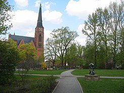
The Rudolfplatz is in the 19th century in connection with the residential development in today's Berlin district of Friedrichshain ( Friedrichshain-Kreuzberg ) landscaped town square . It also forms the center of the Stralau district .
Dimensions, location and description
The square has a trapezoidal shape with the dimensions 160 × 60 meters and is located in the Oberbaum City quarter . The Zwingli Church is on its northwest corner . Rudolfplatz is bordered by Rudolfstraße (north), Modersohnstraße (east), Am Rudolfplatz (south) and Danneckerstraße (west). It is surrounded on two sides by closed rows of houses.
history
The area was laid out according to the Hobrecht plan as Platz H, Dept. XIV . On July 15, 1896, it was given its name, which is still valid today, after the adjacent Rudolfstrasse. Before the church was built, there was a wooden chapel in the square where the residents could hold their services . Carbide lamps illuminated the interior, which is said to have led to breathing problems for some visitors ("they were close to fainting "). The chapel came to Friedrichsfelde after the church building was inaugurated and served there as a cemetery chapel .
One weekend of 1947 artists joined the on Rudolfplatz Camilla Mayer troupe with a tightrope on. The artist boss, Camilla Mayer 2, drove a special motorcycle up a wire rope that was stretched between the bell cage of the Zwingli Church and a bracket on the floor. The public appearance advertised the just wacky film Artists under the clouds .
In the mid-1990s, two segments of the wall were set up next to the entrance to the parish hall , to commemorate the division of Berlin.
layout
The square has a children's play area and a ball playground, and at a crossroads there is a bronze sculpture with two scuffling boys. The artwork, entitled Gambling was a design by Wilfried Fitzenreiter cast in bronze in 1975 and set up here.
Environment and traffic
On the north side of Rudolfplatz there is the daycare center of the Jugendwerk Aufbau Ost e. V. (Rudolfstrasse 15a). To the northeast of the square is the listed building complex of the Emanuel-Lasker-Oberschule (Modersohnstraße). This school building was built between 1909 and 1913 according to plans by the Ludwig Hoffmann town councilor as a community dual school and served as a primary and secondary school.
On the south side, the viewer's gaze falls on a transformer station (Am Rudolfplatz 3).
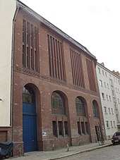
A striking building is the water pumping station XII, built in 1883 (near the square in Rudolfstrasse number 15). The facility consists of an administration building, a civil servants' house and the boiler and machine house. The station transported the wastewater from the former residential areas Friedrichsberg, Boxhagen and Stralau using two pumps installed in 1910 in pipes that led to the sewage fields.
In terms of transport, the square can be reached with the 347 bus .
Web links
- Rudolfplatz. In: Street name lexicon of the Luisenstädtischer Bildungsverein (near Kaupert )
Individual evidence
- ↑ a b c d e Carl-Peter Steinmann: Sunday walks 2 . Transit-Buchverlag, Berlin 2013, ISBN 978-3-88747-286-3 , p. 42/43 .
- ↑ ( page no longer available , search in web archives: end of game ) on bildhauerei-in-berlin.de
- ^ Jugendwerk Aufbau Ost ( Memento from March 4, 2016 in the Internet Archive ), accessed on March 16, 2010.
- ↑ Emanuel-Lasker-Oberschule ( Memento of February 21, 2010 in the Internet Archive ) accessed on March 16, 2010.
Coordinates: 52 ° 30 ′ 10.8 " N , 13 ° 27 ′ 20.7" E

