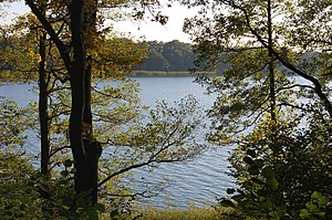
Rudower See
The Rudower See (pronounced: Rudoër ) is an elongated lake in the Prignitz in the outermost northwest corner of Brandenburg . The city of Lenzen is located on its southwest side , less than three kilometers away from the lower middle reaches of the Elbe .
description
The channel-like, southwest-northeast-oriented lake area covers 1.75 km² (175 ha; according to other information 167 ha), with a length of up to 3.77 kilometers and a maximum width of 610 meters. According to the topographic map, the water level is at 15.3 m above sea level . The greatest depth is given as six meters; the volume of the water body is around 6.62 million cubic meters. The water catchment area of the lake has an area of 2985 hectares.
The Rudower See is fed by various marginal sources and by the Nausdorf Canal . This tributary in turn brings water from the northeastern Rambower Moor , which is also fed by many lime-rich springs . The Rudower See is indirectly connected to the Elbe via the Löcknitz via an outflow in the southwest (the so-called “flood”) .
The channel-like surface shape of the surroundings of the Rudower See and Rambower Moor can be traced back to a collapse of the subsoil, which can be dated to a hall glacial . Hydrogen subrosion (dissolution and leaching) of rock salt within the northern part of the Gorleben -Rambow salt structure formed extensive cavities, which finally collapsed and on the surface of what is now the northeastern bank of the Elbe the striking, ten kilometers long and sometimes over one kilometer wide Rambow Lenzener Rinne (compare for example: Arendsee , Maujahn-Moor ). Partly wooded ramparts run along the collapse and reach heights of a maximum of 54.5 m above sea level and thus convey a slightly hilly aspect of the landscape.
At Rudower See there are two (no longer official) bathing areas - near Lenzen and the Leuengarten settlement - as well as a campsite. The fish-rich water is also popular with anglers. During the GDR era, the water quality was heavily polluted due to over-intensive fishing. In the meantime, the situation had improved. However, a phosphate precipitation plant installed on the Nausdorf Canal in 2000 has not been in operation since 2008. In the summer of 2016, after repeated blue algae blooms and later fish deaths, a bathing ban was issued. Faunistically , the lake has, among other things, an importance as a bird breeding and resting area. As the eponymous locality is the isolated yard Rudow (a desert ?) On the north bank.
See also
literature
- Elisabeth von Falkenhausen : Discover the Prignitz - nature and culture of a region . 5th, updated and expanded edition. Hendrik Bäßler Verlag, Berlin 2012, ISBN 978-3-930388-70-7 , Rudower See and Rambower Moor, p. 195 .
Web links
- Rudower See at www.luis.brandenburg.de (PDF online; 227 kB)
- Information on the "Rambower Moor" flow moor ( Memento from May 17, 2013 in the Internet Archive )
Individual evidence
- ↑ "Rettet den Rudower See!", Article in "Kiebitz" (supplement to the Elbe-Jeetzel-Zeitung) from September 21, 2016
Coordinates: 53 ° 6 '22 " N , 11 ° 30' 43" E

