Arendsee (lake)
| Arendsee | ||
|---|---|---|

|
||
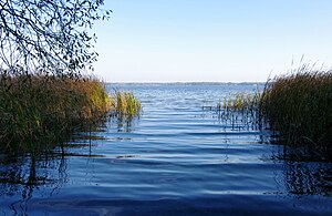
| View through the reed beds on the northwest bank | ||
| Geographical location | North of Saxony-Anhalt | |
| Places on the shore | Arendsee (Altmark) | |
| Data | ||
| Coordinates | 52 ° 53 '21 " N , 11 ° 28' 27" E | |
|
|
||
| surface | 5.138 km² | |
| length | 3.243 km | |
| width | 2 km | |
| Maximum depth | approx. 50 m | |
The Arendsee ( ) is a round-oval lake without bays in the Altmark region in the north of Saxony-Anhalt . With over five square kilometers of water, it is the largest natural lake in the state and at around 50 meters it is also one of the deepest lakes in northern Germany (see also: List of bodies of water in Saxony-Anhalt ). Its emergence goes back to several incursions into the subsoil, most recently in the 17th century.
geography
Location and dimensions
The town of Arendsee is located directly on the south bank ; on the northwest bank the village of Schrampe . The cities of Salzwedel and Lüchow (Wendland) are located in the wider area . The body of water has an area of almost 514 hectares with a west-east extension of up to 3.3 kilometers and a north-south width of two kilometers. The mean depth is around 29 meters, with a maximum of 51 meters. The profile can be characterized as trough-like - with relatively steep slopes and a very extensive, more or less flat depth zone ( profundal ) in the range between 40 and 50 meters. The water level is 23.3 m above sea level. NN ; the deepest point of the ground is thus located around 27 meters below sea level.
Emergence
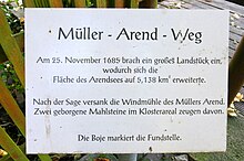
The Arendsee differs in the history of its origins from the majority of natural lakes in the north German lowlands , which are predominantly of Ice Age or periglacial origin. It lies directly above a salt dome . Deep groundwater caused the salt to leach ( subrosion ), which subsequently led to several collapses in the overburden of the salt dome. Recently this happened even in historical times, proven in the years 822 and 1685. The body of water is therefore a water-filled sinkhole ( "Seefall") or collapse doline classify Subrosionssee or Einbruchsee (see, for example: Rudower lake ) and is paid in addition to the Zwischenahner Meer is the largest of its kind in northern Germany. During the last collapse for the time being in 1685, the town's mill sank into the water and the area of the lake is said to have suddenly increased by 20 hectares. According to a legend, the lake and place were renamed after the affected miller Arend. However, the name Arendsee existed much earlier; it was already mentioned as Arnseo in the annals of the Franconian Empire in connection with the break-in in 822.
Further description
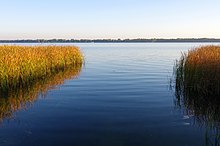
On the west, south and east banks, the subsurface profile drops off quite steeply towards the sea and soon reaches the depth line of 20 meters. Only on the north side are there extensive shallow water areas, so that large-scale reeds made of reeds , narrow-leaved cattails and pond rushes have been able to establish themselves here. The sediments on the lake bed are made up of so-called sea chalk , mud and sand. There should be four superficial tributaries; However, these are only very small in relation to the lake volume. The only recognizable drain is a narrow, only temporarily water-bearing ditch on the north-west bank, which leads to the "Landgraben" (the later "Lüchower Landgraben"). In this - artificial - way, the Arendsee, which actually has no outflow, is indirectly connected to the Elbe via the Jeetzel . On the banks there are mainly forest areas made of black alder , oak and pine , as well as settlement areas including numerous weekend house plots, in the north also some agricultural areas. A circumnavigation of the lake on a hiking and cycling path that is mostly quite close to the shore covers a good ten kilometers.
Landscape protection
The Arendsee lies in the landscape protection area (LSG) Arendsee. The lake with 514 hectares corresponds to about 77.5% of the area of the LSG. The remaining 22.5 percent is formed by a narrow strip of banks around the water. The south adjoining town of Arendsee (Altmark) does not belong to the LSG.
Water quality
The Federal Environment Ministry specifies a total volume of 147 million cubic meters (converted: 147 billion liters) of water and qualifies the Arend Sea as rich or polluted ( eutrophicated ), in particular with a significantly too high total phosphorus content (around 88 µg / l are mentioned as an annual mean value for 2005 or around 200 µgP / l with an upward trend recently.). The statement of an extraordinarily good water quality, for which the Arendsee was praised in the first half of the 20th century ("Perle der Altmark", "Blaues Auge der Altmark"), has to be put into perspective for several decades. Up until the 1970s it was still possible to look into the lake to a depth of more than 6 m, especially in the areas with a pure sand bed. Depending on the time of year, the water today is quite clear, with visibility depths of sometimes over four meters; However, the water can also become very cloudy or a streaky to flaky greenish surface film due to blue-green algae blooms, which are promoted by the high phosphorus and nitrogen content. The causes of the nutrient pollution include discharges of untreated wastewater from municipalities and a dairy in the 1950s and 1960s - a practice that is said to have been abandoned only in 1970. Further entries go back to dachas or holiday home residents and bathers. The high number of guest birds or resting migratory birds is also mentioned in this context . Up to 35,000 Nordic wild geese are said to hibernate at the Arendsee and leave several tons of droppings there. Overstocking with edible fish, namely whitefish , which excessively decimate the water- purifying zooplankton , is also discussed. The latest studies, however, point to the inflow of groundwater and the canal system of the city of Arendsee as the main source of phosphate.
Large-scale attempts to clean up the lake were made in the mid-1970s and mid-1990s. In 1976 a deep water drainage was installed, and in 1995 sea chalk sediments in the northern part were rearranged to cover mud and biomass elsewhere. However, later investigations showed that contrary to expectations, the phosphorus cycle could not be positively influenced in the long term, i.e. in a P -reducing manner.
The fact that the hydrologically relatively "isolated" Arend Sea has an extremely long exchange time of its water body with over 60 (100) years makes a short-term improvement of the nutrient situation particularly difficult. The turnover in the lake is primarily determined by internal processes. The particularly high phosphorus levels during the spring circulation are consumed in early summer by increasing phytoplankton (algae) until their population collapses, a short clear water phase occurs and then nitrogen-fixing cyanobacteria ("blue-green algae") develop. Towards the end of summer stagnation , the depth zone below 40 m is almost free of oxygen. In the summer half of the year, particularly high (basic, alkaline) pH values from phases to over pH 10 are determined.
Above all, under the pressure of the EU Water Framework Directive , which requires the creation of an ecologically good status for all larger bodies of water by 2015, there is currently renewed discussion about remediation options. The introduction of 6500 tonnes of poly aluminum chloride , which is supposed to cause chemical nutrient precipitation, is apparently favored . However, because of the possible ecological effects, this measure is not without controversy. Hunting officials are also calling for a relaxation of the shooting ban on wild geese, which some even describe as the "main cause" of the blue-green algae problem. Even after the natural disappearance of numerous geese in recent years - these are now frequenting many newly created mountain lakes - the situation has not noticeably improved. In preparation for a possible lake remediation in the coming years, the Berlin Leibniz Institute for Aquatic Ecology is currently (2010, 2011) carrying out water-chemical investigations, with a particular focus on some inflows that may be contaminated with manure and artificial fertilizers.
The quality as bathing water is now rated “very good”, whereby compliance with the guide values of microbial parameters in the previous year was used as a criterion. The exposure to intestinal bacteria such as intestinal enterococci and Escherichia coli was examined . Possible intolerance reactions through contact and swallowing of “blue-green algae” are not included in this assessment.
use
The Arendsee is mainly used for tourism. It serves as bathing water for holiday guests and day vacationers. There are also sports activities such as dragon boating and stand up paddling . Especially in the time of the GDR , the Arendsee was popular as a replacement for holidays by the sea.
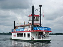
On the north-eastern edge of the town of Arendsee there is a large lido with a lake stand , on which, for example, movies are shown. The lake can be used with sailing dinghies and other non-motorized boats. Since 1991, the Queen Arendsee, modeled on a paddle steamer , has been operating on the lake as an excursion boat in the summer months. The scheduled trips from Arendsee take place in a circular counter-clockwise direction. The use of the lake with other motor boats has been prohibited since 1969. The lake is also used for windsurfing and fishing. Not far from the city of Arendsee, an eleven-meter-long former patrol boat of the NVA was sunk in the Arendsee on October 7, 2006 . It is about 16 m deep and serves as a target for divers .
For decades there has been a small fishing company on the Arendsee that primarily processes the vendace .
Others
The Arendsee belongs to the natural spatial main unit group Wendland and Altmark and forms the southeastern end of the subunit Lüchower Niederung . In terms of natural history, it is of regional importance, among other things as a bird breeding and resting area.
In terms of cultural history, various underwater archaeological finds are worth mentioning, in particular a Neolithic fish fence and a medieval oak prahm , a kind of barge.
The gustaf-nagel area is located on the south bank of the lake .
Individual evidence
- ↑ Müller-Arend-Weg on the south-east bank of the lake, on commons.wikimedia.org
- ↑ Report of the Federal Environment Ministry ( Memento of July 13, 2007 in the Internet Archive )
- ↑ a b State Office for Land Surveying and Data Processing Saxony-Anhalt (ed.): Topographical Map 1: 50,000, normal edition, L 3134 Arendsee (Altmark) , 1st edition 1995.
- ↑ a b c d Brigitte Nixdorf, Mike Hemm, Anja Hoffmann, Peggy Richter: Documentation of the condition and development of the most important lakes in Germany. Part 7: Saxony-Anhalt. Environmental research plan of the Federal Ministry for the Environment, Nature Conservation and Nuclear Safety, final report on R&D project FKZ 299 24 274, Cottbus 2003, (PDF; 307 kB)
- ↑ Depth map of the lake at taucher.net ( memento of the original from October 3, 2015 in the Internet Archive ) Info: The archive link was inserted automatically and has not yet been checked. Please check the original and archive link according to the instructions and then remove this notice. , accessed October 2, 2015
- ↑ Origin of the Arendsee: Sunken Mill and Paths. State Office for Prehistory.
- ^ Rau, R. (1955): Sources on the Carolingian history of the empire, T.1: Die Reichsannalen. Selected sources on German history in the Middle Ages, 5, 5, Wiss. Buchges., Darmstadt, 484 pp.
- ↑ a b Elbe-Jeetzel-Zeitung: Chemical club against algae. Newspaper article from May 10, 2010, p. 24
- ^ Project page IGB Berlin
- ↑ a b c Elbe-Jeetzel-Zeitung: European Union makes steam. Newspaper article from May 7, 2011, p. 12
- ↑ Article in the Berliner Zeitung of August 24, 1994
- ↑ Summary of a scientific paper ( Memento of the original from September 28, 2007 in the Internet Archive ) Info: The archive link was inserted automatically and has not yet been checked. Please check the original and archive link according to the instructions and then remove this notice.
- ↑ Scientific work on the method of lake restoration by calcite flushing - with further literature on the treatment of the Arendsee ( Memento of the original from April 30, 2003 in the Internet Archive ) Info: The archive link was automatically inserted and not yet checked. Please check the original and archive link according to the instructions and then remove this notice.
- ↑ Leibniz Institute for Freshwater Ecology and Inland Fisheries (IGB): Current measurement data ( memento of the original from June 19, 2015 in the Internet Archive ) Info: The archive link has been inserted automatically and has not yet been checked. Please check the original and archive link according to the instructions and then remove this notice. (pH value 10.20; accessed on June 16, 2011)
- ^ Article in the Elbe-Jeetzel-Zeitung from June 9, 2007
- ↑ Bathing water map - Arendsee , accessed on January 12, 2016.
- ↑ Queen Arendsee is going on an anniversary trip , accessed on January 12, 2016.
- ↑ report at ov.salzwedel.thw.de ( Memento of 7 June 2009 at the Internet Archive ) (archive version of 2009), accessed on October 2, 2015
Web links
- Information on underwater archaeological research and finds in the Arendsee (PDF; 2.76 MB)
- Data overview from the Leibniz Institute for Freshwater Ecology and Inland Fisheries (IGB) (including daily updates for water temperature, pH value and visibility depth)
- Arendsee rehabilitation project of the Leibniz Institute for Freshwater Ecology and Inland Fisheries (IGB)


