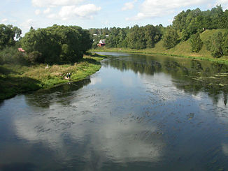
Rusa (Moscow River)
|
Rusa Ру́за |
||
| Data | ||
| Water code | RU : 09010101112110000023201 | |
| location | Smolensk Oblast , Moscow Oblast ( Russia ) | |
| River system | Volga | |
| Drain over | Moskva → Oka → Volga → Caspian Sea | |
| source | on the edge of the Moscow ridge 55 ° 53 ′ 37 ″ N , 35 ° 12 ′ 31 ″ E |
|
| muzzle |
Moskva Coordinates: 55 ° 37 ′ 42 " N , 36 ° 16 ′ 53" E 55 ° 37 ′ 42 " N , 36 ° 16 ′ 53" E
|
|
| length | 145 km | |
| Catchment area | 1990 km² | |
| Outflow at the Rusa gauge |
MQ |
13.1 m³ / s |
| Small towns | Rusa | |
|
Course of the Rusa (Ру́за) in the catchment area of the Moskva |
||
The Rusa ( Russian Ру́за ) is a left tributary of the Moskva in the Smolensk Oblast and Moscow in central Russia .
The Rusa rises on the edge of the Moscow ridge in the Smolensk Oblast, not far from the border with Moscow Oblast. It flows mainly in an easterly direction into Moscow Oblast, later it gradually turns to the southeast. Finally, it reaches the Moskva River about 100 km west of the capital Moscow . Above the small town of the same name, Rusa , the river is dammed by a dam.
The Rusa has a length of 145 km. It drains an area of 1990 km². It is mainly fed by the snowmelt . The river floods in April and May . The mean discharge at the Rusa gauge is 13.1 m³ / s. The river usually freezes in November and remains ice-covered until April.

