Southern bracket head
| Southern bracket head | ||
|---|---|---|
|
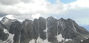
Bracket heads from the northwest, on the far right the southern bracket head |
||
| height | 3117 m above sea level A. | |
| location | East Tyrol / Carinthia border , Austria | |
| Mountains | Schobergruppe | |
| Coordinates | 46 ° 57 '24 " N , 12 ° 45' 34" E | |
|
|
||
| Normal way | from the Niedere Gradenscharte over the former Klammerkees (not difficult ) | |
The southern bracket head is a 3117 m above sea level. A. high mountain peaks of the Schobergruppe on the border between East Tyrol and Carinthia . The southern clamp head is the fifth highest of the seven clamp heads .
location
The southern Klammerkopf is located in the south-eastern center of the Schober Group on the border between the communities of Kals am Großglockner (East Tyrol) in the west, Heiligenblut am Großglockner in the north and Großkirchheim in the west (both Carinthia). The southern Klammerkopf is located between the Keeskopf ( 3081 m above sea level ) in the southeast and the western Klammerkopf ( 3126 m above sea level ) in the north. The Weißenkar saddle ( 2972 m above sea level ) lies between the southern Klammerkopf and the Keeskopf . The Klammerkees used to be to the east of the southern Klammerkopf, whereby the source streams that arise here flow into the nearby Gradensee . To the west of the southern Klammerkopf lies the Weißenkar. The closest alpine bases on Gradensee are the Adolf-Noßberger-Hütte in the southeast, the Lienzer Hütte in the southwest and the Elberfelder Hütte in the north.
Promotion opportunities
The normal route to the little-used southern Klammerkopf leads initially marked from the Adolf-Noßberger-Hütte to the southwest to the Niedere Gradenscharte. At an altitude of around 2900 meters, you then cross below the eastern ridge of the Keeskopf to the former Klammerkees and then climb to the summit ( easy / I ). Alternatively, the ascent is also possible over the barely used Weißenkar saddle and then on the south ridge (not difficult ).
Individual evidence
literature
- Walter Mair: Alpine Club Leader Schobergruppe. Bergverlag Rudolf Rother, Munich 1972, ISBN 3-7633-1222-6 .
- Georg Zlöbl: The three thousand meter peaks of East Tyrol in the Hohe Tauern National Park . Verlag Grafik Zloebl, Lienz-Tristach 2007, ISBN 3-200-00428-2 .
- Alpine Club Map 1: 25,000, sheet 41, Schobergruppe , ISBN 978-3-928777-12-4 .

