Elberfelder Hut
| Elberfelder Hütte DAV hut category I |
||
|---|---|---|
| location | Rear Gössnitz valley; Carinthia , Austria ; Valley location: Heiligenblut | |
| Mountain range | Schobergruppe | |
| Geographical location: | 46 ° 58 '40 " N , 12 ° 45' 37" E | |
| Altitude | 2346 m above sea level A. | |
|
|
||
| builder | Elberfeld section of the DuOeAV | |
| owner | Wuppertal section of the DAV | |
| Built | 1928 | |
| Construction type | hut | |
| Usual opening times | End of June to mid-September | |
| accommodation | 12 beds, 40 camps | |
| Winter room | 6 bearings | |
| Web link | Elberfelder Hut | |
| Hut directory | ÖAV DAV | |
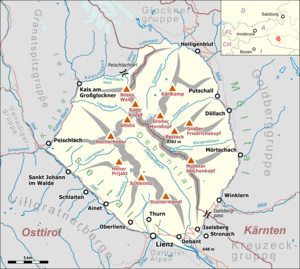
The Elberfelder Hütte is an alpine refuge of the Wuppertal section of the German Alpine Club in the Schober group in the Austrian Alps. It is located at 2346 m above sea level. A. Höhe in the rear of the Gössnitz valley and is cultivated from the end of June to mid-September.
history
The Elberfelder Hütte, named after the Elberfeld district of Wuppertal , was built in 1928 by the Elberfeld section of the DuOeAV (renamed the Wuppertal section since 2005 ). In 1982 and 1983 the hut was renovated and expanded due to an avalanche damage. In 2005, the facade and the roof were repaired. The hut has its own hydropower plant for energy supply and is only supplied by helicopter.
The hut is located in the working area of the "Wuppertal Section" of the German Alpine Club. The Gelsenkirchen , Recklinghausen and Siegburg sections take on the tasks and burdens of hut maintenance.
Approaches
- From Heiligenblut via the Elberfelder Weg through the Gössnitz Valley in 4 to 5 hours
- From Heiligenblut across the Langtal lakes in 6 hours
- Via the Lienzer Hütte and the Gössnitzscharte in 4 hours
All times refer to the pure walking time without breaks and delays.
Tours
Summit tours
- Red button , 3281 m above sea level A. To the second highest peak of the Schobergruppe in 3½ hours.
- Böses Weibl , 3119 m above sea level A. Via the Wiener Höhenweg in 3 hours.
- Kreuzkopf, 3103 m above sea level A. Walking time 2½ hours.
- Glödis , 3206 m above sea level A. Walking time: 5½ hours.
- High board head , 3078 m above sea level A.
Transitions
The Elberfelder Hütte is located on the Wiener Höhenweg , which leads from the Iselsberg to the Glocknerhaus . The neighboring huts can be reached as follows:
- A crossing on the Wiener Höhenweg leads to the Adolf-Noßberger-Hütte over the Hornscharte ( 2958 m above sea level ), which takes 5 hours to walk.
- The shorter transition to the Noßbergerhütte over the Klammerscharte is only advisable in good snow conditions. From mid-July it is usually dangerous and not recommended due to the high risk of falling rocks and evaporation.
- The Glorerhütte in the Glockner Group can also be reached via the Wiener Höhenweg in 5–6 hours via the Kesselkeessattel and the Peischlachtörl.
- Via the Gössnitzscharte ( 2737 m above sea level ) located south of the hut to the Lienzer hut in 3–4 hours.
- Via the Leibniztörl ( 2591 m above sea level ) in 7 hours to the Hochschoberhütte .
Others
On September 8, 2016 shortly after taking off from a supply flight to the Elberfelder Hütte, the pilot Hannes Arch crashed his helicopter and died. The hut warden who flew spontaneously was rescued injured.
literature
- Alpine Club Map (1: 25,000), sheet 41, Schobergruppe . German Alpine Club, Munich 2014
Web links
Individual evidence
- ↑ About us. German Alpine Club Sections Barmen and Wuppertal, accessed on 23 August 2020 .
- ↑ Link ( Memento of the original dated November 30, 2011 in the Internet Archive ) Info: The archive link was inserted automatically and has not yet been checked. Please check the original and archive link according to the instructions and then remove this notice.
- ↑ Elberfelder Hut. German Alpine Club Sections Barmen and Wuppertal, accessed on 23 August 2020 .
- ↑ Hannes Arch: Search for the cause of the crash. In: ORF , September 9, 2016.


