
Wiener Höhenweg
The Wiener Höhenweg is a mountain route for a multi-day, high-alpine hike in the Hohe Tauern National Park in the Schobergruppe , on the border between East Tyrol and Carinthia . The path connects several huts, which also serve as bases, and is around 35 km long. It is part of the "Europa Höhenweg No. 6" ( Großglockner - Vittorio Veneto ) and was built between 1928 and 1933 by the Vienna Alpine Club sections and opened in 1934.

description
The route leads from the Winklerner Hütte via the Wangenitzseehütte , Adolf-Noßberger-Hütte , Elberfelder Hütte , Glorerhütte , Salmhütte to the Glocknerhaus . It is usually climbed in five daily stages, the walking time is around four to six hours per day and there are daily differences in altitude of up to around 750 m. The ascent to the Winklerner Hütte does not count as a stage, but it is a beautiful hike from Iselsberg and takes about two hours.
Stages
| stage | description | Altitude | Duration | target |
|---|---|---|---|---|
| Approach | The ascent to the Winklerner Hütte does not count as a stage, but it is a beautiful hike from Iselsberg and takes about two hours. | 790 m | two hours |

|
| 1st stage | The first stage starts at the Winklerner Hütte and is rated as not very difficult. Mostly a good climb, only above the Wangenitzsee is a short insured area. The walking time is four hours, with 697 vertical meters in the ascent and 100 vertical meters in the descent. The goal of the first stage is the Wangenitzseehütte | 697 m | four hours |

|
| 2nd stage | The second stage from the Wangenitzseehütte to the Adolf-Noßberger-Hütte takes 4.5 hours. The stage is categorized as moderately difficult, there are some exposed parts to overcome. The highest point is the Kreutzschartl ( 2810 m above sea level ). 520 vertical meters in the ascent and 560 m in the descent have to be mastered. | 520 m | 4.5 hours |

|
| 2nd stage variant |
The variant of the second stage leads over the Hohe Gradenscharte ( 2803 m above sea level ) and is considered difficult, in bad conditions (snow or icing) it is not advisable to use this variant. Walking time four hours, with an ascent of 345 meters and a descent of 365 meters. | 345 m | four hours | |
| 3rd stage | The third stage from the Adolf-Noßberger-Hütte to the Elberfelder Hütte leads on the original route over the Klammerscharte, which is often not used due to falling rocks, the variant over the Hornscharte is usually preferable. Crampons and ice ax are often recommended, depending on the circumstances, even a prerequisite. The highest point of this stage is the Hornscharte ( 2958 m above sea level ), the walking time is five hours, with 638 meters of altitude to be mastered in the ascent and 780 m in the descent. The walking time can be considerably longer depending on ability and traffic jams in the gap. | 638 m | five hours |

|
| 4th stage | The fourth stage is categorized as moderately difficult, but requires perseverance. The highest point is the Kesselkees Sattel ( 2962 m above sea level ), the stage leads from the Elberfelder Hütte to the Glorerhütte . There are 732 meters in altitude to master in the ascent and 436 m in the descent. | 732 m | five hours |

|
| 5th stage | The fifth and last stage is classified as moderately difficult, the walking time is given as 4.5 hours. The highest point is the Glatzschneid ( 2660 m above sea level ). There are 260 meters in altitude to master in the ascent and 749 m in the descent. Particular care is required when descending via the Glatzschneid and the Stockerscharte. The stage leads from the Glorerhütte via the Salmhütte to the Glocknerhaus | 260 m | 4.5 hours |
.JPG)
|
conditions
Alpine sure-footedness , a head for heights , ability to orientate yourself , especially in fog, average fitness and appropriate mountain hiking equipment. The indicated walking times are guidelines for dry weather. If it is slippery or wet, a considerably higher expenditure of time must be expected. For the third stage, depending on the season, crampons and ice ax may be necessary.
summit
- The Petzeck 3283 m above sea level. A. is the highest summit of the Schobergruppe and can be reached from the Wangenitzseehütte within three hours, either after the first or before the second stage, the descent takes two hours and there are 775 meters of altitude to master, the route is as characterized little difficult.
- The Keeskopf 3,081 m above sea level. A. can be reached on the second stage from the lower Gradenscharte in an hour. In the summit area there is a short, easy climb, otherwise the ascent is not considered to be difficult.
- The Evil Woman 3121 m above sea level. A. can be reached on the fourth stage in about 45 minutes under good conditions. From the Gernot-Röhr bivouac on the Kesselkees-Sattel 2926 m above sea level. A. leads a little more difficult climb to the summit.
- The red button 3281 m above sea level. A. is climbed from the Elberfelder Hütte in three hours, it is considered to be moderately difficult, current information should be obtained from the owner of the Elberfelder Hütte. There are 935 meters of altitude to master.

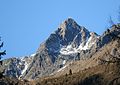
The Petzeck with Kruckelkopf and Hoher Perschitzkopf taken from the west of the Keeskopf location

The structure of the summit of the Petzeck, seen from the normal route
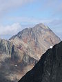
Keeskopf from the south, from the Debant valley

Keeskopf from the southeast, from the Niederen Gradenscharte, in the foreground the ice lake

Bad woman on the ascent from Peischlachtörl
Red button from the southeast, from the Keeskopf


Literature and maps
- Günter Mussnig: Der Wiener Höhenweg , ed. OeAV
- Alpine Club Card Schobergruppe No. 41, published by OeAV
- Alpine Club Card Glockner Group No. 40, published by OeAV
Individual evidence
- ↑ Tauernalpin: Höhenweg Europa No. 6 ( Memento of the original from June 24th, 2009 in the Internet Archive ) Info: The archive link was inserted automatically and has not yet been checked. Please check the original and archive link according to the instructions and then remove this notice.
- ↑ Alpenverein: Der Wiener Höhenweg ( Memento of the original from August 21, 2010 in the Internet Archive ) Info: The archive link has been inserted automatically and has not yet been checked. Please check the original and archive link according to the instructions and then remove this notice.
- ↑ OeAV: The Wiener Höhenweg - unique trekking route in the heart of the Hohe Tauern National Park (Schobergruppe) ( Memento from January 1, 2012 in the Internet Archive )