High Perschitzkopf
| High Perschitzkopf | ||
|---|---|---|
|
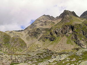
The Hohe Perschitzkopf (center) seen from the southeast. The apparently highest point half right is the Eastern Perschitzkopf ( 3077 m ) |
||
| height | 3125 m above sea level A. | |
| location | Carinthia and Tyrol , Austria | |
| Mountains | Schobergruppe | |
| Dominance | 0.7 km → Kruckelkopf | |
| Notch height | 151 m ↓ Perschitzscharte | |
| Coordinates | 46 ° 56 '22 " N , 12 ° 47' 11" E | |
|
|
||
| rock | Granite , amphibolite , eclogite | |
| First ascent | July 26, 1890 by Mathias Marcher and Ludwig Purtscheller | |
| Normal way | From the Wangenitzseehütte or the Adolf-Noßberger-Hütte over the Hohe Gradenscharte | |
The Hohe Perschitzkopf , a mountain with a height of 3125 m above sea level. A. , is located in the Schober group of the Hohe Tauern in Austria . The summit is located approx. 12 km as the crow flies north of Lienz in East Tyrol , exactly on the border line with Carinthia . The normal ascent is relatively easy to climb in dry and snow-free conditions. From the summit you can enjoy a beautiful view of the mountain world of the Schober group, especially to the Petzeck and Hochschober , in appropriate weather conditions .
First ascent
On July 26, 1890 Mathias Marcher and Ludwig Purtscheller reached the highest point. However, the summit was probably already entered for surveying purposes.
rise
The normal ascent to the Hohen Perschitzkopf is from the Wangenitzseehütte or the Adolf-Noßberger-Hütte to the Hohen Gradenscharte ( 2803 m ). Then the unmarked ascent runs over the south ridge in easy block climbing to the summit. The ascent is of difficulty I + and takes around 2.5 hours from the Wangenitzseehütte and around 3 hours from the Adolf-Noßberger-Hütte.
Minor peaks
The secondary peak, the Eastern Perschitzkopf ( 3,077 m above sea level ), can be climbed from the Wangenitzseehütte. The unmarked path leads over rubble heaps and block fields into the Perschitzscharte. Then the ascent leads over the northeast ridge in block climbing of difficulty I + to the summit.
More pictures
The Petzeck on the left, the Kruckelkopf in the middle , the Hohe Perschitzkopf on the right, seen from the north-west
Literature and map
- Alpine club map sheet 41, 1: 25,000, Schobergruppe , ISBN 3-928777-12-2 .
- Walter Mair: Alpine Club Leader Schobergruppe . Bergverlag Rudolf Rother, Munich 1979. ISBN 3-7633-1222-6 .
- Georg Zlöbl: The three-thousand-meter peaks of East Tyrol in the Hohe Tauern National Park , Verlag Grafik Zloebl 2005, ISBN 3-200-00428-2 .
Web links
Individual evidence
- ↑ Clem Clements, Jonathan de Ferranti, Eberhard Jurgalski , Mark Trengove: The 3000 m SUMMITS of AUSTRIA - 242 peaks with at least 150 m of prominence , October 2011, p. 16.
- ↑ Federal Office for Metrology and Surveying Austria: Hoher Perschitzkopf on the Austrian Map online (Austrian map 1: 50,000)


