
Skógá
| Skógá | ||
 The Skógá river with one of its many waterfalls |
||
| Data | ||
| location | Iceland | |
| River system | Skógá | |
| source |
Fimmvörðuháls 63 ° 37 ′ 53 ″ N , 19 ° 26 ′ 50 ″ W. |
|
| muzzle |
Atlantic Ocean Coordinates: 63 ° 29 ′ 40 " N , 19 ° 34 ′ 0" W 63 ° 29 ′ 40 " N , 19 ° 34 ′ 0" W |
|
| Mouth height |
0 m
|
|
| Waterfalls: Skógafoss | ||
The Skógá is a river in the south of Iceland in the Suðurland region . It rises on the Fimmvörðuháls highland pass between the two glaciers Eyjafjallajökull and Mýrdalsjökull . It flows over about 20 waterfalls , whereby the Skógafoss with a drop height of 60 meters is the highest and at the same time the last before it flows into the sea. You can already see the Skógafoss near the town of Skógar in the Icelandic municipality of Rangárþing eystra from ring road No. 1 . According to an old Icelandic saga , one of the first immigrants named 'Þrasi' hid a box of gold behind the waterfall.
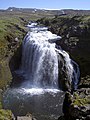
One of the many waterfalls in the upper reaches of the Skóga.

The largest and last waterfall Skógafoss in the course of the Skóga river.

The river below the Skógafoss waterfall before it flows into the sea.


.jpg)