Saito (Miyazaki)
| Saito-shi 西 都市 |
||
|---|---|---|
| Geographical location in Japan | ||
|
|
||
| Region : | Kyushu | |
| Prefecture : | Miyazaki | |
| Coordinates : | 32 ° 7 ' N , 131 ° 24' E | |
| Basic data | ||
| Surface: | 438.56 km² | |
| Residents : | 29,149 (October 1, 2019) |
|
| Population density : | 66 inhabitants per km² | |
| Community key : | 45208-4 | |
| Symbols | ||
| Flag / coat of arms: | ||
| Tree : | Myrica rubra | |
| Flower : | Rhododendron dilatatum | |
| Bird : | Japanese Bush Warbler | |
| town hall | ||
| Address : |
Saito City Hall 2 - 1 Seiryō-chō Saito -shi Miyazaki 881-0015 |
|
| Website URL: | http://www.city.saito.miyazaki.jp | |
| Location Saitos in Miyazaki Prefecture | ||
Saito ( Japanese 西 都市 , -shi ) is a Japanese city in Miyazaki Prefecture on the southern Japanese island of Kyūshū .
history
The city was founded on April 1, 1951 .
Attractions
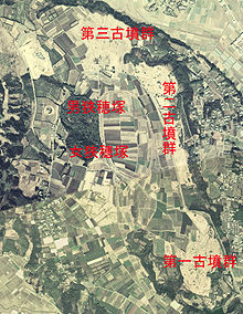
Saito is known for the Saitobaru-Kofun group ( 西 都 原 古墳 群 , Saitobaru kofun-gun ). The more than 300 kofun that were built between the 4th and 7th centuries make it one of the largest collections of kofun in Japan. In 1952 the Kofun Group was named a Special Historic Site. The Kofun Matsuri is held every fall .
traffic
- Streets:
- Higashi-Kyushu Highway
- National road 219
sons and daughters of the town
- Yoshikazu Mera (* 1971), opera singer (countertenor)
Neighboring cities and communities
Individual evidence
- ^ Miyazaki> Saitobaru. Japan National Tourist Association, accessed September 21, 2008 .
Web links
Commons : Saito - collection of images, videos and audio files


