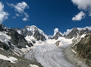
Saleina glacier
| Saleina glacier | ||
|---|---|---|
|
Saleinagletscher and Aiguille d'Argentière (left) |
||
| location | Valais , Switzerland | |
| Mountains | Mont Blanc group , Graian Alps | |
| Type | Valley glacier | |
| length | 6.1 km (October 2010) | |
| surface | 8.82 km² 1995 | |
| Exposure | East to Northeast | |
| Altitude range | 3900 m - 1793 m | |
| Ice volume | 0.43 ± 0.11 km³ (1995) | |
| Coordinates | 568 579 / 90648 | |
|
|
||
| drainage | Reuse de Saleina, Dranse de Ferret , Rhone | |
The Saleinagletscher (French Glacier de Saleina ) is a valley glacier southwest of Orsières on the northeast slope of the Mont Blanc massif , in the extreme southwest of the canton of Valais .
In October 2010, a length of 6.1 km was determined for the glacier. Including the side glaciers, the area in 1995 was approximately 8.8 km². The exposure of the nutrient area is east, that of the consumption area is northeast.
The Saleinagletscher has its origin on the eastern slope of Aiguille d'Argentière and Aiguille du Chardonnet , over which the border between Switzerland and France runs, it extends there up to an altitude of 3900 m above sea level. The glacier flows to the east, absorbing firn fields from the surrounding mountain peaks. It is flanked in the north by the Aiguilles Dorées (up to 3519 m above sea level) and the Portalet (3344 m above sea level), in the south by the Pointe du Grand Darray (3509 m above sea level). The narrow glacier tongue ends on a steep slope, in 2007 at an altitude of 1793 m above sea level. M. The glacier drains into the Reuse de Saleina , which flows into the Dranse de Ferret .
On the slope south of the glacier stands at 2691 m above sea level. M. the Cabane de Saleina , a hut belonging to the Swiss Alpine Club . It serves as a starting point for summit and glacier tours in the north-eastern Mont-Blanc massif. There are firn-covered, but steep pass crossings to the adjacent glaciers: Trient glacier in the north, Glacier du Tour in the west and Glacier d'Argentière in the south-west, the latter both in France.
Web links
- Research institute for hydraulic engineering, hydrology and glaciology (VAW) of the ETH Zurich (ed.): Saleinagletscher. In: Swiss Glacier Measurement Network. ( ethz.ch , also as PDF ).
- Research institute for hydraulic engineering, hydrology and glaciology (VAW) of the ETH Zurich : Saleinagletscher. In: Glacier Natural Hazards. ( ethz.ch ( page no longer available ), also as a PDF ( page no longer available )).
- Saleinagletscher on the ETHorama platform
Individual evidence
- ↑ a b Research Institute for Hydraulic Engineering, Hydrology and Glaciology (VAW) of the ETH Zurich (ed.): Saleinagletscher. In: Swiss Glacier Measurement Network. ( ethz.ch , also as PDF , accessed on November 30, 2012).
- ↑ a b c Daniel Farinotti, Matthias Huss, Andreas Bauder, Martin Funk: An estimate of the glacier ice volume in the Swiss Alps. In: Global and Planetary Change. 68: 225-231, 2009 ( online ; PDF; 756 kB).
- ^ A b World Glacier Monitoring Service (WGMS): Fluctuations of Glaciers 2000-2005 (Vol. VIII). Zurich 2008 ( online ( memento of the original from 23 September 2013 in the Internet Archive ) Info: The archive link has been inserted automatically and has not yet been checked. Please check the original and archive link according to the instructions and then remove this note .; PDF; 820 kB)
- ↑ swisstopo.ch: Swisstopo geodata viewer, as of November 2012
- ↑ Expert commission for cryosphere measuring networks (EKK) of the Swiss Academy of Sciences (SCNAT): The Swiss Glaciers 2005/2006 and 2006/2007. Glaciological Report No. 127/128. 2011 ( online ; PDF; 5.5 MB)

