Glacier d'Argentière
| Glacier d'Argentière | ||
|---|---|---|
|
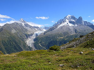
Glacier d'Argentière from the north-west, the Aiguille Verte on the top right |
||
| location | Haute-Savoie , France | |
| Mountains | Mont Blanc group , Graian Alps | |
| Type | Valley glacier | |
| length | 9 km | |
| surface | 14 km² | |
| Exposure | northwest | |
| Altitude range | 3000 m - 1600 m | |
| Coordinates | 45 ° 57 '37 " N , 6 ° 58' 46" E | |
|
|
||
| drainage | Torrent de Lognan, Arve , Rhone | |

The Glacier d'Argentière is a valley glacier in the eastern Mont-Blanc group . It is located in the French department of Haute-Savoie , southeast of Argentière .
geography
The Glacier d'Argentière has its origin in the northwest flank of Mont Dolents and runs almost ten kilometers to the northwest towards Argentière . It is enclosed on both sides by two high mountain ranges, from whose steep flanks it is fed. Orographically on the left is the Aiguille de Triolet - Les Courtes - Les Droites - Aiguille Verte chain , which slopes down to the Glacier d'Argentière with its steep, icy north faces. Further north is the Aiguille des Grands Montets , whose east side carries the Glacier des Rognons, which flows into the Glacier d'Argentière. Orographically to the right of the Glacier d'Argentière runs the Aiguilles Rouges du Dolent - Tour Noir - Aiguille d'Argentière - Aiguille du Chardonnet chain , over which the French-Swiss border runs. The southwest slopes of this chain carry several smaller glaciers that flow into the Glacier d'Argentière. Further down the valley at around 2100 m , the Glacier d'Argentière breaks off and is interrupted by a steep rock step (see also the picture opposite). The last section, completely separated from the main glacier, extends up to about 1,600 m .
Touristic
On the orographic right edge of the Glacier d'Argentière is the Refuge d'Argentière ( CAF ) at 2771 m . The hut is reached via the glacier and serves as the starting point for numerous mountain tours in the area.
In winter, a stage of the Haute Route , a well-known ski route , leads over the Glacier d'Argentière.
At the summit of the Aiguille des Grands Montets there is a cable car station of the Grands Montets ski area, from which a slope leads over the Glacier des Rognons, on the edge of the Glacier d'Argentière to Argentière.
Web links
- Glacier d'Argentière online on Glaciers
- Glacier d'Argentière on the ETHorama platform

