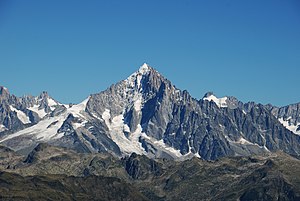
Aiguille Verte
| Aiguille Verte | ||
|---|---|---|
|
Aiguille Verte (center) and Aiguille du Dru (in front) |
||
| height | 4122 m | |
| location | Haute-Savoie ( France ) | |
| Mountains | Montblanc massif , western Alps | |
| Dominance | 7.2 km → Grandes Jorasses | |
| Notch height | 689 m ↓ L'Aiguillon | |
| Coordinates | 45 ° 56 '9 " N , 6 ° 58' 10" E | |
|
|
||
| First ascent | June 29, 1865 by Edward Whymper , Christian Almer and Franz Biner | |
|
The Aiguille Verte (center) with the double-peaked Aiguille du Dru (left) and Les Droites (right) |
||
The Aiguille Verte ( French for: "Green Needle") with a height of 4122 meters is a mountain in the Montblanc massif . It is considered to be one of the most difficult, if not the most difficult, four-thousand-meter peaks in the Alps to climb .
Location and surroundings
The Aiguille Verte is surrounded by large glaciers . In the west, the Mer de Glace flows around the mountain range . In the south lies the large glacier basin of the Glacier de Talèfre . In the north, the Glacier d'Argentière flows with a long tongue into the Chamonix valley . On the west ridge of the Aiguille Verte, with the forbidding double summit of the Aiguille du Dru, rise two of the most famous and difficult climbing mountains in Europe, where alpine history was written. To the east, the Droites , 4000 m , and the Courtes , 3856 m , are joined by impressive mountain figures, the difficult north faces of which rise from the Argentière basin.
The Refuge du Couvercle , a hut of the French Alpine Club CAF located south of the mountain at 2687 m , is ideal as an alpine base . The hut can be reached from the Montenvers train station in around 3.5 hours (glacier walk).
Alpinism
- The easiest ascent is the Whympercouloir, named after the first person to climb, an ice channel with an average incline of 47 ° , which is now exposed in hot summers . In the upper part the steepness increases up to 55 °. The tour is almost only possible in early summer, when the snow conditions are still favorable . Because of the increasing danger of falling rocks when it gets warm , you should have left the channel early in the morning. With Edward Whymper reached on 29 June 1865 and Christian Almer and Franz Biner first time the culmination of the Verte.
- Alternatively, you can climb the south pillar of the Grande Rocheuse , 4102 m , which rises to the right of the Whympercouloir , and from this secondary peak you can reach the highest peak via the summit ridge (difficulty in the rock up to UIAA III). Michel Balmat, Michel Ducroz and R. Fowler first walked the route over the southern spur of the Rocheuse on September 17, 1865 when they climbed the Verte for the third time.
- The so-called Moinegrat offers a (often combined, i.e. ice-covered) ascent over the southwest ridge of the Aiguille Verte. A few days after the first climbers, GC Hodgkinson, Charles Hudson , TS Kennedy, Michel Croz , MA Ducroz and Peter Perren followed this route to the summit on July 5, 1865. The difficulties in the rock reach the third degree according to the UIAA scale.
Crossing the ridge of the Verte is one of the largest undertakings that advanced mountaineers can undertake in the Alps.
The notorious, up to 60 ° steep Nant-Blanc route was first used in 1989 by Jean-Marc Boivin on skis and ten years later by Marco Siffredi on his snowboard.
Web links
- Aiguille Verte on Summitpost
- Aiguille Verte at 4000m - the four-thousanders of the Alps
Individual evidence
- ^ Trey Cook: The Disappearance Of Marco Siffredi. snowboarding.transworld.net, September 8, 2013, accessed on August 16, 2017 .


