San Blas (Nayarit)
| San Blas | |
|---|---|
|
Coordinates: 21 ° 32 ′ N , 105 ° 17 ′ W
San Blas on the map of Nayarit
|
|
|
Location of San Blas in Mexico
|
|
| Basic data | |
| Country | Mexico |
| State | Nayarit |
| Municipio | San Blas |
| City foundation | 1768 |
| Residents | 10,187 (2010) |
| Detailed data | |
| height | 10 m |
| Post Code | 63640 |
| prefix | 323 |
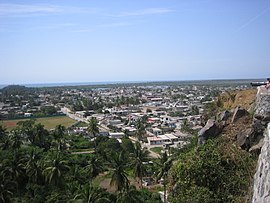
| San Blas from the land side | |
San Blas is a fishing village with around 10,000 inhabitants on the Pacific coast of Mexico and the capital of the municipality of the same name . It is located between Puerto Vallarta and Mazatlán in the state of Nayarit in the northwest of the country.
geography
The village is located on the Pacific coast of Mexico. Located at a river mouth, there was a natural harbor protected from the wind . The village is surrounded by mangrove forests , 16 kilometers from the mouth of the Río Grande de Santiago . The Marias Islands belonging to the municipality of San Blas are about 120 kilometers offshore. The state capital Tepic is 60 kilometers away.
City structure
The village is divided into twenty districts.
history
Settlement has been proven since 1531. In 1768 Junípero Serra came to the place where he set off on his journey to California. The official founding date is set at the arrival of Don Manuel Rivera with 116 families to settle the area. In May of the same year, San Blas was declared a Spanish naval base. It was used primarily for supply and communication with the missions in California and beyond. Since that time, however, the port has also played an important role in long-distance trade and shipbuilding, despite its small size.
From 1830 at the latest, the USA posted a consul to the administration of American affairs in San Blas, who later became responsible for the entire Pacific coast.
Economy and Infrastructure
Because of its quiet atmosphere away from the tourist centers, San Blas has retained the reputation of an insider tip. Windsurfing and swimming are among the most popular activities. Boat trips are also offered through the protected marshland. However, fisheries and agriculture continue to be important sources of income. The main crops are green beans , millet and tobacco . In addition, cattle breeding is a major economic factor for the place. The population development has been declining for many years.
traffic
San Blas is located on the Mexican coastal road, via which Tepic and the neighboring communities can be reached by bus or private transport. Small sailing ships and pleasure craft can call at the shallow water harbor. There is a 750 m long runway for light aircraft in the town center .
Individual evidence
- ↑ a b Enciclopedia de los Municipios y Delegaciones de México: San Blas (Spanish)
- ^ Library of Congress . Retrieved February 25, 2010.


