San Martino in Strada
| San Martino in Strada | ||
|---|---|---|
|
|
|
|
| Country | Italy | |
| region | Lombardy | |
| province | Lodi (LO) | |
| Local name | San Martin | |
| Coordinates | 45 ° 18 ' N , 9 ° 35' E | |
| height | 73 m slm | |
| surface | 13 km² | |
| Residents | 3,752 (Dec 31, 2019) | |
| Population density | 289 inhabitants / km² | |
| Post Code | 26817 | |
| prefix | 0371 | |
| ISTAT number | 098048 | |
| Website | San Martino in Strada | |
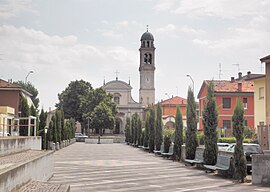
 Village view |
||
San Fiorano is a municipality with 3752 inhabitants (as of December 31, 2019) in the province of Lodi in the Italian region of Lombardy .
Districts
The residential areas Ca 'de' Bolli and Sesto are located next to the main town in the municipality.
Web links
Commons : San Martino in Strada - Collection of images, videos and audio files
Individual evidence
- ↑ Statistiche demografiche ISTAT. Monthly population statistics of the Istituto Nazionale di Statistica , as of December 31 of 2019.
- ↑ ISTAT - Dettaglio località abitate

