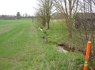
Sandbach (Luhe)
| Sandbach | ||
|
Sandbach near Frankenrieth |
||
| Data | ||
| Water code | DE : 14322 | |
| location |
Upper Palatinate Forest
|
|
| River system | Danube | |
| Drain over | Luhe → Naab → Danube → Black Sea | |
| source | Northwest of Goldbrunn 49 ° 41 ′ 43 ″ N , 12 ° 19 ′ 33 ″ E |
|
| Source height | approx. 583 m | |
| muzzle | southwest of Albersrieth in die Luhe Coordinates: 49 ° 39 '39 " N , 12 ° 17' 24" E 49 ° 39 '39 " N , 12 ° 17' 24" E |
|
| Mouth height | approx. 487 m | |
| Height difference | approx. 96 m | |
| Bottom slope | approx. 17 ‰ | |
| length | 5.6 km | |
| Catchment area | 15.75 km² | |
The Sandbach is a 5.55 km long, right tributary of the Luhe in the district of Neustadt an der Waldnaab in the Upper Palatinate in Bavaria .
course
A 460 m long source stream of the Sandbach rises on the southwest slope of the 641 m high Hummelberg northwest of Goldbrunn in the Lohwiese in the municipality of Waldthurn . Another 280 m long source stream rises in the valley between Hummelberg and the 588 m high dome west of Goldbrunn. Both source streams unite 620 m west of Goldbrunn.
The Sandbach initially flows 1 km to the northwest along the north side of the dome. Then it swings in a south-westerly direction, which it essentially maintains until it flows into the Luhe.
The Sandbach passes the Kühbachhof and reaches Frankenrieth, where it takes in an unnamed stream from the right. It flows along the eastern edge of Frankenrieth and passes under State Road 2181 . Other unnamed streams flow to the Sandbach from the right and left.
The Sandbach flows through a valley between the 524 m high Lohbühl in the northwest and the 555 m high Maienberg in the southeast. South of the Lohbühl near the Lindnermühle, the 1.9 km long Schammesriether Bach flows into the Sandbach from the right.
The Sandbach flows in an arch to the west around the 521 m high Steinbühl with the town of Albersrieth . Here the Sandbach flows along the border between the communities Theisseil and Waldthurn. West of Albersrieth, the 2.78 km long Irlbach flows from the right. Southwest of Albersrieth, after a further 330 m, the 1.67 km long Vockhofbach flows from the left.
20 m further on on the border between the municipalities of Waldthurn and Vohenstrauß , the Sandbach flows into the Luhe from the right.
Tributaries
From the source to the mouth:
- Schammesriether Bach from the right
- Irlbach from the right
- Vockhofbach from the left
Individual evidence
- ↑ a b c course and catchment area of the Sandbach in Bavaria Atlas. Retrieved October 8, 2018
- ↑ a b Length and catchment area according to: Directory of creek and river areas in Bavaria - Naab river area, page 68 of the Bavarian State Office for the Environment, as of 2016 (PDF; 4.0 MB)
