Sant Martí (Barcelona)
|
Sant Martí district of the city of Barcelona |
|
|---|---|
| Coordinates | 41 ° 25 '4 " N , 2 ° 11' 55" E |
| surface | 10.52 km² |
| Residents | 228,701 (2009) |
| Population density | 21,740 inhabitants / km² |
| politics | |
| District Mayor | Francesc Narváez i Pazos (PSC) |
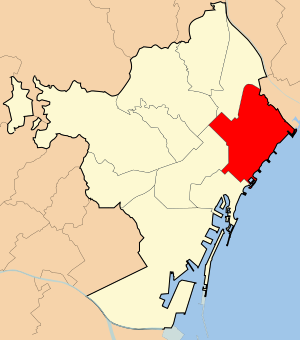
Sant Martí is the tenth district of the Catalan capital, Barcelona . It is located in the east of the metropolis and borders the districts of Ciutat Vella , Eixample , Horta-Guinardó and Sant Andreu , as well as the city of Sant Adrià de Besòs . Most of Barcelona's beaches are located within the district's 2,675 meters of coastline.
With an area of 10.52 square kilometers, Sant Martí ranks fourth and with 231,855 inhabitants (2009) second among the urban districts in Barcelona.
history
The name of the district was taken from the municipality of Sant Martí de Provençals . The place was independent from 1714 to 1897 and the first parish church was dedicated to Saint Martin of Tours . The addition to the name de Provençals is derived from the Latin provincialis , which the Romans used to designate areas beyond the city walls. The old village stretched to the east of the city of Barcelona from the city walls to the Besòs river and from the sea to Mount Carmel .
With the construction of the Rec Comtal irrigation canal , which carried water from Montcada to Barcelona , the place initially developed northwards from the 11th century. From the middle of the 17th century on the marshland in the south, the first commercial enterprises emerged, which later became the most active industrial areas in all of Spain .
To 1716 was Sant Martí de Provençals a parish under the jurisdiction of Santa Maria del Mar . The municipality was independent until it was incorporated into the city of Barcelona.
In the 18th century the first industries arose in the lower area of Sant Martí, the Poblenou . The reasons were the low land prices, the availability of water, the proximity to the port of Barcelona and the very low taxes. These factors led to a massive settlement of industrial companies in the 19th century: from 1885 to 1888 the number of factories increased from 60 to 243. Initially there were mills, later the textile industry, tanneries, brickworks, chemical industry and many others. At the end of the 19th century, the quarter had changed into a purely industrial and working-class district.
Neighborhood within the district
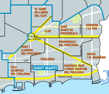
The Sant Martí district is divided into ten neighborhoods:
| code | Surname | Population (2009) |
Area (ha) |
Population density (people / ha) |
|---|---|---|---|---|
| 64 | El Camp de l'Arpa del Clot | 38,917 | 74.2 | 524.7 |
| 65 | El Clot | 27,562 | 69.6 | 396.0 |
| 66 | El Parc i la Llacuna del Poblenou | 13,457 | 111.4 | 120.8 |
| 67 | La Vila Olímpica del Poblenou | 9,202 | 94.3 | 97.6 |
| 68 | Poblenou | 31,433 | 154.5 | 203.5 |
| 69 | Diagonal Mar i el Front Marítim del Poblenou | 31,433 | 154.5 | 203.5 |
| 70 | El Besòs i el Maresme | 24,527 | 127.4 | 192.5 |
| 71 | Provençals del Poblenou | 19,542 | 110.5 | 176.9 |
| 72 | Sant Martí de Provençals | 26,457 | 74.5 | 354.9 |
| 73 | La Verneda i la Pau | 29,626 | 112.3 | 263.9 |
| X | Sant Martí | 231,855 | 1,052.4 | 220.3 |


