Sants-Montjuïc
|
Sants-Montjuïc district of the city of Barcelona |
|
|---|---|
| Coordinates | 41 ° 21 '17 " N , 2 ° 8' 44" E |
| surface | 22.94 km² |
| Residents | 182,692 (2008) |
| Population density | 7964 inhabitants / km² |
| Website | District de Sants-Montjuic |
| politics | |
| District Mayor | Eduard Freixedes Plan (CiU) |
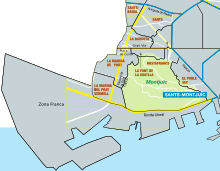
Sants-Montjuïc is the third of the ten boroughs of the Catalan capital, Barcelona . With an area of 22.94 square kilometers, it takes up more than a fifth of the total area of Barcelona, which makes it the largest in the city. In terms of population, it is the third largest city district. In addition to extensive urban residential, service and commercial facilities, the district has extensive green spaces and houses most of the port of the Mediterranean city, which is also reflected in the population density, which is around 8,000 inhabitants / km², only about half that in the entire city.
history
Before Sants was incorporated into the city of Barcelona in 1897, it was an independent municipality in the Pla de Barcelona area , located on Camí Ral and was named Santa Maria de Sants . There were two main areas of settlement - on the one hand, the central Sants, and the Marina de Sants, which is located near today's port. In the 19th century, Sants benefited enormously from its location at the gates of the city of Barcelona, from which many entrepreneurs relocated their activities to Sants in order to save taxes. The construction of the railway south from Barcelona reinforced these tendencies.
geography
location
Sants-Montjuïc makes up the southernmost part of the city, and is bordered to the west by the city of L'Hospitalet de Llobregat and to the south by El Prat de Llobregat , where the international airport is located. Adjacent districts are Les Corts in the northwest , the Eixample in the north and the Ciutat Vella (old town) in the northeast .
Neighborhood in the district
The city district is divided into the following districts and areas:
| code | Surname | Population (2009) |
Area (ha) |
Population density (people / ha) |
|---|---|---|---|---|
| 11 | El Poble-sec | 41,018 | 94.3 | 434.8 |
| 12 | La Marina del Prat Vermell | 1,085 | 75.3 | 14.4 |
| 13 | La Marina de Port | 30,128 | 125.5 | 240.1 |
| 14th | La Font de la Guatlla | 10,336 | 30.2 | 342.1 |
| 15th | Hostafrancs | 16,208 | 41.0 | 395.1 |
| 16 | La Bordeta | 18,823 | 57.7 | 326.5 |
| 17th | Sants-Badal | 24,507 | 41.1 | 596.9 |
| 18th | Sants | 42,438 | 109.8 | 386.6 |
| - | Montjuïc Park | 0 | 366.1 | 0 |
| - | Zona Franca port area | 0 | 1,353.1 | 0 |
| III | Sants-Montjuïc | 184,543 | 2,294.0 | 80.4 |
Transport and infrastructure
traffic
In the city district, the Estació de Sants station is the busiest station in the city, with long-distance connections to many destinations on the Iberian Peninsula and the rest of Europe. All Rodalies Barcelona lines are connected to Sants station. One of the city's bus stations is also connected to the train station.
The Sants-Montjuïc district is crossed by the underground lines L1 , L3 and L5 of the Barcelona Metro , the L8 line , together with some regional connections, has its starting point under Plaça Espanya , one of the monumental squares in the district. A dense bus network offers further fine-tuning as well as direct inner-city connections that are not offered by the subway.
The municipal rental bike system Bicing is represented throughout the district's residential areas, and the bike paths and lanes have been gradually expanded in recent years.
The district of Sants-Montjuïc is crossed by the first and second ring roads around the city of Barcelona, which connect the districts with each other and the city with regional and national highways. The Gran Via de les Corts Catalanes , one of the main arteries of the city, cuts through the municipality. Other important streets are the Avinguda del Paral lel, Carrer de Numància and Carrer de Tarragona. The streets Carrer de Sants and Carrer de la Creu Coberta also attract many residents and tourists with their specialty shops.
Web links
- El web de Sants | Information neighborhoods Sants, Hostafrancs i La Bordeta
- Botigues de Sants | Sants Trade Directory Sants, Hostafrancs i la Bordeta
- Festa Major de Sants 2010
Individual evidence
- ↑ http://www.bcn.es/estadistica/castella/dades/guiadt03/terri03/t1.htm ( page no longer available , search in web archives ) Info: The link was automatically marked as defective. Please check the link according to the instructions and then remove this notice. Statistics on bcn.es
- ↑ Sants district on bcn.es


