from Wikipedia, the free encyclopedia
Aerial view of Barahona 2014
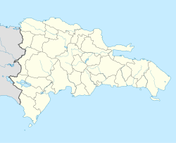
Santa Cruz de Barahona is the largest city in the province of Barahona in the south of the Dominican Republic with 132,600 inhabitants. It is particularly characterized by its ecotourism . There is also the traditional planting and processing of sugar cane .
Climate table
Average monthly temperatures and rainfall for Barahona
Jan
Feb
Mar
Apr
May
Jun
Jul
Aug
Sep
Oct
Nov
Dec
Max. Temperature ( ° C )
29.3
29.2
29.5
30.0
30.3
30.7
31.7
31.9
31.5
30.7
30.6
29.8
O
30.4
Min. Temperature (° C)
20.3
20.7
21.6
22.6
23.3
24.1
24.3
24.0
23.3
22.6
21.8
20.7
O
22.4
Precipitation ( mm )
30.4
29.3
45.1
64.1
168.5
129.5
38.1
65.1
143.7
184.9
75.6
44.4
Σ
1,018.7
Rainy days ( d )
3.7
3.2
3.9
6.1
10.6
8.2
3.8
5.1
8.8
10.6
4.8
2.4
Σ
71.2
T
Jan
Feb
Mar
Apr
May
Jun
Jul
Aug
Sep
Oct
Nov
Dec
N
30.4
29.3
45.1
64.1
168.5
129.5
38.1
65.1
143.7
184.9
75.6
44.4
Jan
Feb
Mar
Apr
May
Jun
Jul
Aug
Sep
Oct
Nov
Dec
sons and daughters of the town
Casandra Damirón (1919–1983), singer
María Montez (1912–1951), actress
Ramón Oviedo (1924-2015), painter
Milton Peláez (1945–2006), rock musician, composer and comedian
Aníbal de Peña (* 1933), singer, pianist and composer
Teresa Pérez Frangie (born 1946), singer
Augusto Sánchez (* 1983), racing cyclist
Luis Alfredo Torres (1935–1992), poet, journalist and critic
Individual evidence
Web links
The German cargo ship MS Vogelsberg loading sugar - Santa Cruz de Barahona, 1959
<img src="https://de.wikipedia.org//de.wikipedia.org/wiki/Special:CentralAutoLogin/start?type=1x1" alt="" title="" width="1" height="1" style="border: none; position: absolute;">


