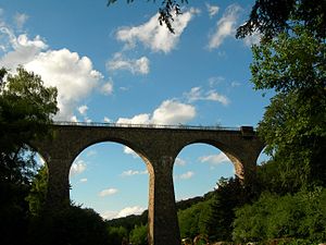
Eulenbach Bridge
Coordinates: 51 ° 20 ′ 29 ″ N , 7 ° 1 ′ 49 ″ E
| Eulenbach Viaduct | ||
|---|---|---|
| use | originally a railway bridge , today a bike / hiking trail | |
| Convicted |
Niederbergbahn (standard gauge, single-track) today: Panoramaradweg Niederbergbahn |
|
| Subjugated | Rinderbach (Ruhr) | |
| place | Velbert | |
| construction | Natural stone arch bridge | |
| overall length | 168 m | |
| Number of openings | 7th | |
| Longest span | 20 m | |
| height | 40 m | |
| start of building | 1914 | |
| completion | 1916 | |
| opening | February 15, 1924 | |
| planner | Elberfeld Railway Directorate | |
| location | ||
|
|
||
The Eulenbach Bridge in Velbert , also known as the Eulenbach Viaduct , but better known as the Saubrücke among the population , is a former railway bridge that was built from natural stone from 1914 . The bridge is part of the Niederbergbahn and was used for train traffic until the 1990s. Today it is part of the Niederbergbahn Panorama Cycle Path , which leads from Wülfrath to Essen - Kettwig .
history
The expansion of the branch line, which has led from Aprath to Velbert in one lane since 1888 , and on to Heiligenhaus and Kettwig remained controversial for a long time. After approval in May 1912, construction began on July 23, 1913. Several bridges had to be built, from May 1914 the largest of the bridges was built, namely the Eulenbach Bridge planned by the Elberfeld Railway Directorate. After the outbreak of World War I , construction work was suspended for the time being, but could be completed by summer 1915 with the help of unemployed factory workers and Russian prisoners of war . An accident caused a stir in the summer of 1915 when a construction train fell off the bridge. Nobody was injured. After the bridge was almost completed, construction work on the railway was stopped in 1916 and only resumed after the end of the World War. But since this could only be continued with interruptions afterwards, the railway line and thus also the bridge did not start operating until February 15, 1924 for freight traffic. A year later, on March 31, 1925, the railway line was also opened for passenger traffic.
Passenger traffic on the railway ended in 1960. After that, freight transport continued for over 30 years until the last official freight train passed the Eulenbach Bridge on December 28, 1994. The use of the bridge ended with the closure of the Niederbergbahn , which took place in 2006. In the years that followed, there were discussions about building a cycle path on the former railway line , which should then also lead over the Eulenbach Bridge. After the plans were finalized in 2009, construction work began the following year. The Eulenbach Bridge has been used again since the cycle path opened on July 16, 2011. The panorama bike path Niederbergbahn leads from Essen-Kettwig to Wülfrath.
Construction
The Eulenbach Bridge, which spans the Eulenbach Valley on seven arches with a span of around 20 meters each, is 168 meters long. The core of the bridge, which consists of rammed concrete , was faced with quarry stone on the outside . With a height of 40 meters, it was the highest bridge faced with natural stone in the former Prussian Rhine province .
Surname
The official name of the bridge is Eulenbachbrücke and comes from the Rinderbach river , which flows through the valley spanned by the bridge and is also known regionally as Eulenbach. The name Eulenbach still exists today as a street name in the form of Uelenbeek. After a short time, the bridge was popularly known as the “Saubrücke” - named after a courtyard in the middle of the valley that was demolished in 1965 and was called In der Sau , where Sau stands for swamp.
literature
- Horst Degen (Ed.): Velbert. History of three cities. JP Bachem Verlag, Cologne 2009, ISBN 978-3-7616-1843-1 , p. 247.
Web links
- The Saubrücke. Now she's wearing again. Article from July 19, 2011 on www.derwesten.de , last accessed on September 23, 2019

