
Sohag
|
سوهاج Sohag |
|||
|---|---|---|---|
|
|||
| Coordinates | 26 ° 33 ' N , 31 ° 42' E | ||

|
|||
| Basic data | |||
| Country | Egypt | ||
| Sauhaj | |||
| ISO 3166-2 | EG-SHG | ||
| Residents | 209,000 (2010) | ||

Sohag ( Arabic سوهاج, DMG Sawhāǧ , also Suhag or Suhaj ), Egyptian-Arabic pronunciation Sōhāg or Sōhādsch , is a city in Egypt on the west bank of the Nile . Its population is estimated at around 201,000 in 2012. It has been the capital of the governorate of the same name since 1960 .
geography
Sohag is located on the west bank of the Nile in a fertile agricultural landscape, about 6 km southwest of Achmim . Also two islands, the uninhabited Karaman-ez-Zahur and the smaller but populated Gazirat ez-Zahur ( Arabic جزيرة الزهور; Ǧazīrat az-Zuhūr, "flower island") are parts of the local area. Sohag therefore bears the name "Bride of the Nile".
climate
| Sohag | ||||||||||||||||||||||||||||||||||||
|---|---|---|---|---|---|---|---|---|---|---|---|---|---|---|---|---|---|---|---|---|---|---|---|---|---|---|---|---|---|---|---|---|---|---|---|---|
| Climate diagram | ||||||||||||||||||||||||||||||||||||
| ||||||||||||||||||||||||||||||||||||
|
Average monthly temperatures for Sohag
Source: missing
|
|||||||||||||||||||||||||||||||||||||||||||||||||||||||||||||||||||||||||||||||||||||||||||||||||||||||||||||||||||||||||||||||||||||||
history
The prehistory of the place is largely unknown, some mummies from the time of Roman rule have been found. At the time of the Copts , a community of monks lived in the so-called "White Monastery". This place was only an insignificant place until the 19th century, only when the provincial capital was relocated from Girga that Sohag received its current name.
The governorate's national holiday is celebrated here on April 10th, in memory of the Battle of Johaina, where in 1799 Egyptian troops defeated a French advance division of the Egyptian expedition Napoleon Bonapartes .
economy
Since there are only a few archaeologically significant sites in Sohag, tourism only accounts for a small part of the city's economic activity. Trade, small industry (carpet weavers, furniture production, spinning mills, weaving mills and sugar production), as well as the provincial administration and a university ensure population growth and income. Between 1976 and 2010 the population grew from 101,758 to 209,419.
Facilities and selected structures
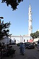
- Sidi Arif Mosque (مسجد العارف بالله; Masjid al-ʿArif bi-Allah) in the south of the urban area, built in the 14th century
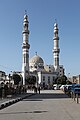
- El-Farshuti Mosque (مسجد الفرشوطى; Masjid al-Farschūṭī), also el-'Atiq (الجامع العتيق; "The old one") called, near the Sidi Arif mosque. Modern building with a 53 m high minaret , in the facade there are some writing stones from the old building, u. a. a decree of the Mamelukes - Sultan al-Ghuri (1441-1516) from the year 1506
- Church of the Holy Virgin (Kanīsat as-Saiyida al-ʿAdraʾ) north of the bazaar (souq Qaiṣarīya), built in the 20th century. The church has five naves and is consecrated to the Virgin Mary, has side chapels for St. George and the Archangel Michael.
- Church of St. George (Kanīsat Mar Girgis), Cathedral of the Sohag Eparchy , near the Opera House (Midan Obira), also from the 20th century
- Church of the Archangel Michael in Bahnhofsstrasse (El-Mahatta)
- The Coptic White Monastery , dedicated to Saint Schenute of Atripe , 5 km west of the city. The name is derived from the white limestone of the building. Today only the church remains as a remnant of the once large monastery.
- The Coptic Orthodox Red Monastery , dedicated to the Egyptian Saint Pishay, 5 km north of the city. The name comes from the red fired bricks on the outer wall.
- Temple of the goddess Repit , built by Ptolemy XV. Caesarion on an earlier temple of Ptolemy IX. (see also Athribis (Menu) , Athribis Project ). Nearby is the grave of the Ibpemeny and Pemehyt brothers from the late 2nd century BC. With two zodiac frescos on the ceiling.
- The Sohag Museum has a collection of 5,000 artifacts from across Sohag Governorate, covering the period from the Middle Kingdom to the Greco-Roman times.
- Non-state regional university in Sohag, which trains hydraulic engineers and Germanists, among other things
Picture gallery

Sohag skyline at dawn
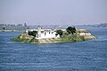
Gazirat ez-Zahur

Midan Corniche with the town hall
Sidi Arif mosque
El-Farshuti mosque

Church of the Holy Virgin

White monastery

Spolie (time of the pharaohs) in the White Monastery


Web links
Individual evidence
- ↑ World Gazetteer: Sohag ( Memento from December 16, 2012 in the web archive archive.today )
- ^ Gwillim Law: Administrative subdivisions of countries. A comprehensive world reference, 1900 through 1998 . McFarland, Jefferson, NC [et. a.] 1999, ISBN 0-7864-0729-8 , pp. 114 ( books.google.com ).
- ^ Richard Talbert: Barrington Atlas of the Greek and Roman World , ISBN 0-691-03169-X , p. 77.
- ↑ [1] , Homepage Universität Sohag (en), accessed on February 20, 2020.